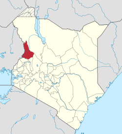
West Pokot County
| West Pokot County | |||
|---|---|---|---|
| County | |||
| |||
 Location in Kenya | |||
| Coordinates: 1°14′00″N 35°07′00″E / 01.23333°N 035.1167°ECoordinates: 1°14′00″N 35°07′00″E / 01.23333°N 035.1167°E | |||
| Country |
| ||
| Formed | March 4, 2013 | ||
| Capital | Kapenguria | ||
| Government | |||
| • Governor | Simon Kitelei | ||
| Area | |||
| • Total | 8,418.2 km2 (3,250.3 sq mi) | ||
| Population (2009)[1] | |||
| • Total | 512,690 | ||
| • Density | 61/km2 (160/sq mi) | ||
| Time zone | EAT (UTC+3) | ||
| Website | westpokot.go.ke | ||
West Pokot County is a county of Kenya. Its capital and largest town is Kapenguria. The county has a population of 512,690[2] (2009 census) and an area of 8,418.2 km².
People
Pokot people inhabit the area.
Kengen's Turkwel Hydro Power Plant is also situated in West Pokot County. It is a power plant that produces about 105MW of power that is fed to the national grid. Communities around the power plant and the extensive districts of West Pokot and Turkana do not enjoy the benefits coming from the power plant.
Tegla Loroupe, one of the most famous Kenyan female runners is from West Pokot.
Geography
Mount Mtelo is located in West Pokot County.
County subdivisions
| Local authorities (councils) | |||
| Authority | Type | Population* | Urban pop.* |
|---|---|---|---|
| Kapenguria | Municipality | 56,019 | 12,984 |
| Chepareria | Town | 8,212 | 901 |
| Pokot | County | 243,855 | 0 |
| Total | - | 308,086 | 13,885 |
| * 1999 census. Source:[3] | |||
| Administrative divisions | |||
| Division | Population* | Urban pop.* | Headquarters |
|---|---|---|---|
| Alale | 29,679 | 0 | |
| Chepareria | 68,518 | 900 | Chepareria |
| Chesegon | 21,343 | 0 | |
| Kacheliba | 20,151 | 0 | |
| Kapenguria | 62,746 | 12,438 | Kapenguria |
| Kasei | 9,879 | 0 | |
| Kongelai | 20,018 | 0 | Kongelai |
| Lelan | 32,931 | 0 | |
| Sigor | 42,821 | 0 | Sigor |
| Total | 308,086 | 13,338 | - |
| * 1999 census. Sources[4][5] | |||
The district has four constituencies:
- Kacheliba Constituency
- Kapenguria Constituency
- Sigor Constituency
- Pokot South Constituency
Notable residents
- Lonah Chemtai, Kenyan-Israeli Olympic marathon runner
References
- ↑ http://www.scribd.com/doc/36672705/Kenya-Census-2009
- ↑ http://www.scribd.com/doc/36672705/Kenya-Census-2009
- ↑ http://treasury.go.ke/cbs.go.ke/pdf/authority.pdf
- ↑ http://www.cck.go.ke/html/final_annex1_cover_status.pdf
- ↑ http://www.ilri.cgiar.org/html/Urban%20Poverty%20all%20Kenya%20Province%20through%20Location%20Final.xls
External links
This article is issued from Wikipedia - version of the 8/26/2016. The text is available under the Creative Commons Attribution/Share Alike but additional terms may apply for the media files.


