Savage station
| MARC commuter rail station | |||||||||||
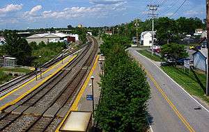
 Baltimore-bound view of the platforms of Savage MARC station and Brock Bridge Road as seen from Dorsey Run Road. | |||||||||||
| Location |
9009 Dorsey Run Road Savage, MD 20723 | ||||||||||
| Coordinates | 39°07′22″N 76°47′47″W / 39.1229°N 76.7963°WCoordinates: 39°07′22″N 76°47′47″W / 39.1229°N 76.7963°W | ||||||||||
| Line(s) | |||||||||||
| Platforms | 1 side platform, 1 island platform | ||||||||||
| Tracks | 3 | ||||||||||
| Connections |
| ||||||||||
| Construction | |||||||||||
| Parking | Yes | ||||||||||
| Traffic | |||||||||||
| Passengers (2013) | 471 (MARC) | ||||||||||
| Services | |||||||||||
| |||||||||||
Savage is a passenger rail station on the MARC Camden Line between Washington, DC and Baltimore's Camden Station.[2] It is officially located at 9009 Dorsey Run Road in Savage, Maryland, however Dorsey Run Road runs over the railroad tracks as well as Brock Bridge Road, which runs along the south side of the tracks and is a street-level with the station. The station straddles the line between Howard County and Anne Arundel County, with the southbound platform and parking garage located in Howard County and the northbound platform in Anne Arundel County.
Savage Station runs along the former Baltimore and Ohio Railroad's Capital Subdivision, which is now owned by CSX. It is also near the former Annapolis Junction which included a former Baltimore and Annapolis Railroad line.
Nearby places and attractions
Communities
Employment centers
- National Security Agency
- National Cryptologic Museum
- Giant-Landover Jessup Fresh Food Facility
- Regional Transportation Agency of Central Maryland
- National Business Park
- Dorsey Run Road Businesses
References
- ↑ http://www.meaderide.com/wp-content/uploads/2010/10/Savage-MARC-NSA-Shuttle1.pdf
- ↑ "MARC Train System Map and Station List". Maryland Transit Administration. Retrieved 2008-03-12.
External links
- Savage station official website
-
 Media related to Savage station at Wikimedia Commons
 - Station from Dorsey Run Road from Google Maps Street View