| [3] |
Name on the Register[4] |
Image |
Date listed[5] |
Location |
City or town |
Description |
|---|
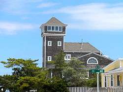
| 1 |
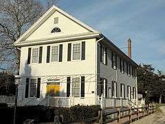
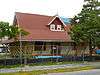
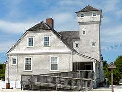
Avalon Life Saving Station |
|
000000001979-03-02-0000March 2, 1979
(#79001480) |
76 W. 15th St.
39°06′14″N 74°42′46″W / 39.103889°N 74.712778°W / 39.103889; -74.712778 (Avalon Life Saving Station) |
Avalon |
|
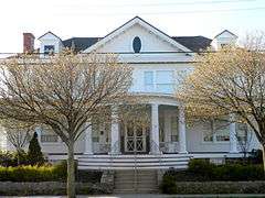
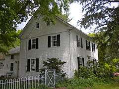
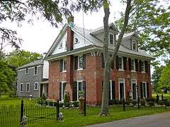
| 2 |
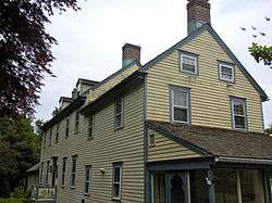
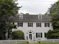
J. Thompson Baker House |
|
000000001996-05-31-0000May 31, 1996
(#96000551) |
3008 Atlantic Ave.
38°59′N 74°49′W / 38.99°N 74.81°W / 38.99; -74.81 (J. Thompson Baker House) |
Wildwood |
|
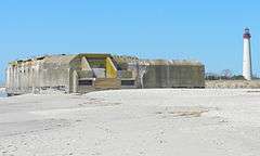
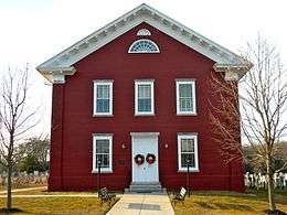
| 3 |
Battery 223 |
|
000000002008-06-25-0000June 25, 2008
(#08000555) |
Beach at Cape May State Park
38°55′53″N 74°57′20″W / 38.931489°N 74.955533°W / 38.931489; -74.955533 (Battery 223) |
Lower Township |
|
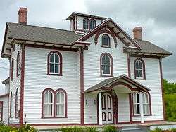
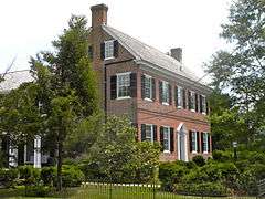
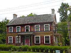
| 4 |
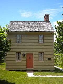
Thomas Beesley Jr. House |
|
000000001998-02-12-0000February 12, 1998
(#98000098) |
605 NJ 9 N
39°05′55″N 74°48′50″W / 39.098611°N 74.813889°W / 39.098611; -74.813889 (Thomas Beesley Jr. House) |
Middle Township |
|
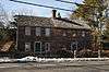
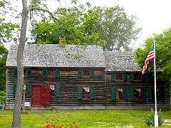
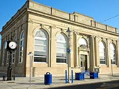
| 5 |
Thomas Beesley Sr. House |
|
000000001992-12-17-0000December 17, 1992
(#92001682) |
12 Beesley's Pl.
Beesley's Point
39°16′47″N 74°37′46″W / 39.279722°N 74.629444°W / 39.279722; -74.629444 (Thomas Beesley Sr. House) |
Upper Township |
|
| 6 |
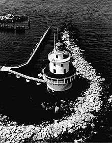
Brandywine Shoal Light Station |
|
000000002007-01-08-0000January 8, 2007
(#06000943) |
In lower Delaware Bay, about 8.8 mi. WNW of Cape May Point
38°59′10″N 75°06′47″W / 38.986111°N 75.113056°W / 38.986111; -75.113056 (Brandywine Shoal Light Station) |
Cape May Point |
|
| 7 |
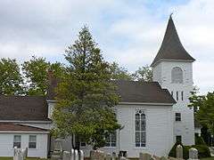
Calvary Baptist Church |
|
000000001980-11-25-0000November 25, 1980
(#80002477) |
SW of Ocean View at Seaville Rd. and NJ 9
39°10′14″N 74°44′26″W / 39.170556°N 74.740556°W / 39.170556; -74.740556 (Calvary Baptist Church) |
Dennis Township |
Built 1855
|
| 8 |
Cape May Historic District |
|
000000001970-12-29-0000December 29, 1970
(#70000383) |
Cape May
38°56′24″N 74°54′46″W / 38.94°N 74.912778°W / 38.94; -74.912778 (Cape May Historic District) |
Cape May |
600 buildings
|
| 9 |
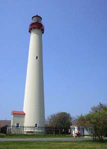
Cape May Lighthouse |
|
000000001973-11-12-0000November 12, 1973
(#73001090) |
Cape May Point State Park
Lighthouse Ave.
38°55′58″N 74°57′39″W / 38.932778°N 74.960833°W / 38.932778; -74.960833 (Cape May Lighthouse) |
Lower Township |
Built 1859
|
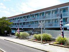
| 10 |
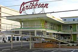
Caribbean Motel |
|
000000002005-08-24-0000August 24, 2005
(#05000915) |
5600 Ocean Ave.
38°58′45″N 74°49′32″W / 38.979167°N 74.825556°W / 38.979167; -74.825556 (Caribbean Motel) |
Wildwood Crest |
Built 1958
|
| 11 |
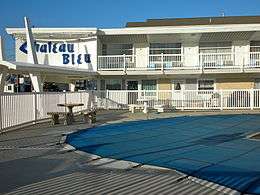
Chateau Bleu Motel |
|
000000002004-03-25-0000March 25, 2004
(#04000221) |
911 Surf Ave.
39°00′05″N 74°47′42″W / 39.001389°N 74.795°W / 39.001389; -74.795 (Chateau Bleu Motel) |
North Wildwood |
|
| 12 |
Owen Coachman House |
|
000000002005-09-09-0000September 9, 2005
(#05000964) |
1019 Batts Ln.
38°57′44″N 74°55′46″W / 38.962222°N 74.929444°W / 38.962222; -74.929444 (Owen Coachman House) |
Lower Township |
|
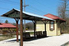
| 13 |
Cold Spring Grange Hall |
|
000000001998-03-30-0000March 30, 1998
(#98000234) |
720 Seahore Rd.
38°58′39″N 74°54′48″W / 38.9775°N 74.913333°W / 38.9775; -74.913333 (Cold Spring Grange Hall) |
Lower Township |
|
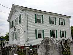
| 14 |
Cold Spring Presbyterian Church |
|
000000001991-06-14-0000June 14, 1991
(#91000785) |
780 Seashore Rd.
38°58′35″N 74°54′59″W / 38.976389°N 74.916389°W / 38.976389; -74.916389 (Cold Spring Presbyterian Church) |
Lower Township |
|
| 15 |
John Corson, Jr. House Site |
|
000000002015-02-12-0000February 12, 2015
(#06000686) |
1542 S. Shore Rd.
39°13′46″N 74°41′09″W / 39.22945°N 74.68591°W / 39.22945; -74.68591 (John Corson, Jr. House Site) |
Upper Township |
|
| 16 |
Dennisville Historic District |
|
000000001987-11-24-0000November 24, 1987
(#87000848) |
Petersburg Rd., Main St., Church Rd., Hall Ave., Fidler and Academy Rds., and NH 47; also roughly bounded by Gatzmer Ave., RR. tracks, NJ 47, and N. side of Petersburg Rd. and NJ 47
Dennisville
39°11′34″N 74°49′16″W / 39.192778°N 74.821111°W / 39.192778; -74.821111 (Dennisville Historic District) |
Dennis Township |
|
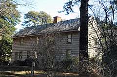
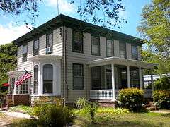
| 17 |
Joseph Falkinburg House |
|
000000001994-10-03-0000October 3, 1994
(#94001153) |
922 Delsea Dr.
South Dennis
39°10′22″N 74°49′15″W / 39.172778°N 74.820833°W / 39.172778; -74.820833 (Joseph Falkinburg House) |
Dennis Township |
|
| 18 |
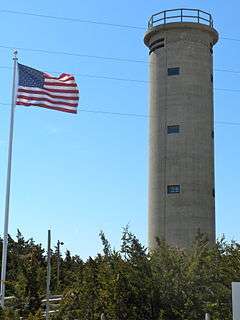
Fire Control Tower No. 23 |
|
000000002003-11-17-0000November 17, 2003
(#03000655) |
Sunset Boulevard
38°56′36″N 74°58′03″W / 38.943333°N 74.9675°W / 38.943333; -74.9675 (Fire Control Tower No. 23) |
Lower Township |
|
| 19 |
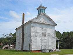
Fishing Creek Schoolhouse |
|
000000001980-03-06-0000March 6, 1980
(#80002478) |
2102 Bayshore Rd.
39°00′51″N 74°56′20″W / 39.014167°N 74.938889°W / 39.014167; -74.938889 (Fishing Creek Schoolhouse) |
Villas |
|
| 20 |
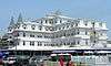
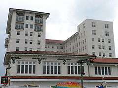
The Flanders Hotel |
|
000000002009-11-20-0000November 20, 2009
(#09000939) |
719 E. 11th St.
39°16′29″N 74°34′36″W / 39.274717°N 74.576792°W / 39.274717; -74.576792 (The Flanders Hotel) |
Ocean City |
|
| 21 |
Judge Nathaniel Foster House |
|
000000002014-08-25-0000August 25, 2014
(#14000516) |
1649 Bayshore Dr.
39°01′13″N 74°56′07″W / 39.0203°N 74.9353°W / 39.0203; -74.9353 (Judge Nathaniel Foster House) |
Lower Township |
|
| 22 |
John Wesley Gandy House |
|
000000001999-11-12-0000November 12, 1999
(#99001309) |
26 Tyler Rd.
Greenfield
39°14′02″N 74°42′24″W / 39.233889°N 74.706667°W / 39.233889; -74.706667 (John Wesley Gandy House) |
Upper Township |
|
| 23 |
Goshen School |
|
000000002014-05-12-0000May 12, 2014
(#14000202) |
314 N. Delsea Dr. (Middle Township)
39°08′14″N 74°51′15″W / 39.137298°N 74.854034°W / 39.137298; -74.854034 (Goshen School) |
Goshen |
|
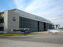
| 24 |
Hangar No. 1-United States Naval Air Station Wildwood |
|
000000001997-08-21-0000August 21, 1997
(#97000935) |
Jct. of Forrestal and Langley Rds.
Cape May Airport
39°00′18″N 74°54′37″W / 39.005°N 74.910278°W / 39.005; -74.910278 (Hangar No. 1-United States Naval Air Station Wildwood) |
Lower Township |
|
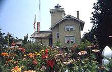
| 25 |
Hereford Lighthouse |
|
000000001977-09-20-0000September 20, 1977
(#77000859) |
Central Ave.
39°00′24″N 74°47′32″W / 39.006667°N 74.792222°W / 39.006667; -74.792222 (Hereford Lighthouse) |
North Wildwood |
Built 1874
|
| 26 |
George Hildreth House |
|
000000001999-07-28-0000July 28, 1999
(#99000905) |
731 Seashore Rd.
38°58′42″N 74°54′44″W / 38.978333°N 74.912222°W / 38.978333; -74.912222 (George Hildreth House) |
Lower Township |
|
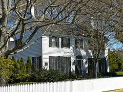
| 27 |
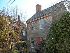
John Holmes House |
|
000000001979-06-12-0000June 12, 1979
(#79001481) |
U.S. 9
39°05′46″N 74°48′48″W / 39.096111°N 74.813333°W / 39.096111; -74.813333 (John Holmes House) |
Cape May Court House |
|
| 28 |
Thomas Leaming House |
|
000000001997-08-01-0000August 1, 1997
(#97000801) |
1845 US 9 N
39°08′30″N 74°46′01″W / 39.141667°N 74.766944°W / 39.141667; -74.766944 (Thomas Leaming House) |
Middle Township |
|
| 29 |
Henry Ludlam House |
|
000000001993-08-12-0000August 12, 1993
(#93000826) |
1336 NJ 47
Dennisville
39°11′43″N 74°50′31″W / 39.195278°N 74.841944°W / 39.195278; -74.841944 (Henry Ludlam House) |
Dennis Township |
|
| 30 |
Thomas Ludlam Jr. House |
|
000000002004-11-26-0000November 26, 2004
(#04001261) |
707 NJ47
39°10′09″N 74°49′31″W / 39.169167°N 74.825278°W / 39.169167; -74.825278 (Thomas Ludlam Jr. House) |
Dennis Township |
|
| 31 |
Marine National Bank |
|
000000002000-12-20-0000December 20, 2000
(#00001494) |
3301 Pacific Ave.
38°59′24″N 74°48′47″W / 38.99°N 74.813056°W / 38.99; -74.813056 (Marine National Bank) |
Wildwood |
|
| 32 |
Marshallville Historic District |
|
000000001989-11-28-0000November 28, 1989
(#89002013) |
Roughly Marshallville Rd. at Co. Rt. 557
39°17′54″N 74°46′42″W / 39.2983°N 74.778242°W / 39.2983; -74.778242 (Marshallville Historic District) |
Upper Township |
|
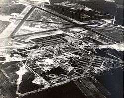
| 33 |
Naval Air Station Wildwood Historic District |
|
000000002015-07-28-0000July 28, 2015
(#13000945) |
Roughly bounded by Forrestal & Monterre Rds., runways & taxiways to N. & E.
39°00′24″N 74°54′23″W / 39.00679°N 74.90651°W / 39.00679; -74.90651 (Naval Air Station Wildwood Historic District) |
Wildwood vicinity |
Former site of Naval Air Station Wildwood, now Cape May Airport
|
| 34 |
New Asbury Methodist Episcopal Meetinghouse |
|
000000001980-09-17-0000September 17, 1980
(#80002476) |
Shore Rd.
39°08′25″N 74°46′10″W / 39.140278°N 74.769444°W / 39.140278; -74.769444 (New Asbury Methodist Episcopal Meetinghouse) |
Cape May Court House |
|
| 35 |
Ocean City 34th Street Station |
|
000000001984-06-22-0000June 22, 1984
(#84002613) |
34th St.
39°15′06″N 74°36′49″W / 39.251667°N 74.613611°W / 39.251667; -74.613611 (Ocean City 34th Street Station) |
Ocean City |
Demolished.[6]
|
| 36 |
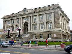
Ocean City City Hall |
|
000000001997-06-13-0000June 13, 1997
(#97000565) |
Jct. of 9th St. and Asbury Ave.
39°16′43″N 74°34′34″W / 39.278611°N 74.576111°W / 39.278611; -74.576111 (Ocean City City Hall) |
Ocean City |
|
| 37 |
Ocean City Life-Saving Station |
|
000000002013-06-14-0000June 14, 2013
(#13000385) |
801 4th St.
39°16′55″N 74°33′56″W / 39.281855°N 74.565679°W / 39.281855; -74.565679 (Ocean City Life-Saving Station) |
Ocean City |
|
| 38 |
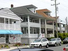
Ocean City Residential Historic District |
|
000000002003-03-20-0000March 20, 2003
(#03000129) |
Roughly bounded by 3rd and 8th Sts. and Central and Ocean Aves.,
39°16′52″N 74°34′14″W / 39.281111°N 74.570556°W / 39.281111; -74.570556 (Ocean City Residential Historic District) |
Ocean City |
|
| 39 |
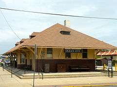
Ocean City Tenth Street Station |
|
000000001984-06-22-0000June 22, 1984
(#84002610) |
10th Street and Haven Avenue
39°16′44″N 74°34′43″W / 39.278889°N 74.578611°W / 39.278889; -74.578611 (Ocean City Tenth Street Station) |
Ocean City |
|
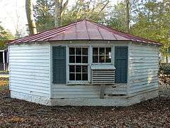
| 40 |
Octagonal Poultry House |
|
000000002008-03-14-0000March 14, 2008
(#08000177) |
720 US 9 (Lower Township)
38°58′46″N 74°54′45″W / 38.979444°N 74.9125°W / 38.979444; -74.9125 (Octagonal Poultry House) |
Cold Spring |
|
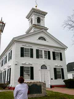
| 41 |
Old Cape May County Courthouse Building |
|
000000001981-12-22-0000December 22, 1981
(#81000389) |
N. Main St.
39°05′02″N 74°49′26″W / 39.083889°N 74.823889°W / 39.083889; -74.823889 (Old Cape May County Courthouse Building) |
Cape May Court House |
|
| 42 |
Jonathan Pyne House |
|
000000001997-02-14-0000February 14, 1997
(#97000061) |
609 Sea Grove Ave.
38°56′18″N 74°57′35″W / 38.938333°N 74.959722°W / 38.938333; -74.959722 (Jonathan Pyne House) |
Lower Township |
|
| 43 |
Reeves-Iszard-Godfey House |
|
000000002005-03-09-0000March 9, 2005
(#05000127) |
3097 Shore Rd.
39°11′49″N 74°42′42″W / 39.196944°N 74.711667°W / 39.196944; -74.711667 (Reeves-Iszard-Godfey House) |
Upper Township |
|
| 44 |
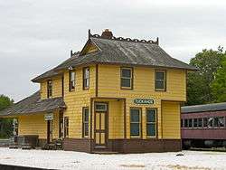
Rio Grande Station |
|
000000002007-02-13-0000February 13, 2007
(#07000047) |
720 NJ 9
38°58′31″N 74°54′41″W / 38.975278°N 74.911389°W / 38.975278; -74.911389 (Rio Grande Station) |
Lower Township |
|
| 45 |
Rufwud Cottage |
|
000000002014-12-02-0000December 2, 2014
(#14000979) |
394 93rd St.
39°03′28″N 74°45′40″W / 39.0578°N 74.7612°W / 39.0578; -74.7612 (Rufwud Cottage) |
Stone Harbor Borough |
|
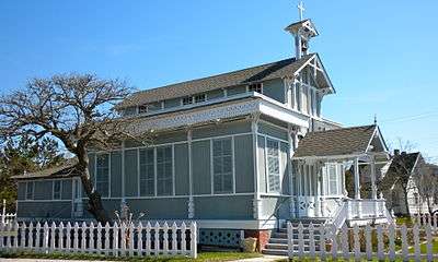
| 46 |
Saint Peter's-By-The-Sea Episcopal Church |
|
000000001995-08-03-0000August 3, 1995
(#95000978) |
Jct. of Ocean Ave. and Lake Dr.
38°56′03″N 74°58′00″W / 38.934167°N 74.966667°W / 38.934167; -74.966667 (Saint Peter's-By-The-Sea Episcopal Church) |
Cape May Point |
|
| 47 |
South Tuckahoe Historic District |
|
000000001997-03-07-0000March 7, 1997
(#97000103) |
Roughly, along NJ 557 and NJ 50 from the Tuckahoe River to Kendall Ln., Upper Township
39°17′20″N 74°45′10″W / 39.288889°N 74.752778°W / 39.288889; -74.752778 (South Tuckahoe Historic District) |
Tuckahoe |
|
| 48 |
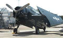
TBM-3E "Avenger" Torpedo Bomber Warplane |
|
000000002003-02-11-0000February 11, 2003
(#03000019) |
500 Forrestal Rd.
Cape May Airport
39°00′17″N 74°54′36″W / 39.004722°N 74.91°W / 39.004722; -74.91 (TBM-3E "Avenger" Torpedo Bomber Warplane) |
Lower Township |
|
| 49 |
William S. Townsend House |
|
000000001984-04-05-0000April 5, 1984
(#84002618) |
96 Delsea Dr.
Dennisville
39°11′35″N 74°49′56″W / 39.193056°N 74.832222°W / 39.193056; -74.832222 (William S. Townsend House) |
Dennis Township |
|
| 50 |
Tuckahoe Station |
|
000000001984-06-22-0000June 22, 1984
(#84002626) |
Railroad Ave. and Mill Rd.
39°17′28″N 74°45′39″W / 39.291111°N 74.760833°W / 39.291111; -74.760833 (Tuckahoe Station) |
Tuckahoe |
|
| 51 |
U.S. Life-Saving Station No. 35 |
|
000000002008-11-08-0000November 8, 2008
(#08000970) |
11617 2nd Ave.
39°02′22″N 74°46′08″W / 39.039328°N 74.768989°W / 39.039328; -74.768989 (U.S. Life-Saving Station No. 35) |
Stone Harbor |
|
| 52 |
Whilldin-Miller House |
|
000000002003-02-12-0000February 12, 2003
(#03000012) |
416 S. Broadway
38°56′04″N 74°55′53″W / 38.934444°N 74.931389°W / 38.934444; -74.931389 (Whilldin-Miller House) |
West Cape May |
|
| 53 |
Woodbine Brotherhood Synagogue |
|
000000001980-09-17-0000September 17, 1980
(#80002479) |
612 Washington Ave.
39°14′21″N 74°49′08″W / 39.239167°N 74.818889°W / 39.239167; -74.818889 (Woodbine Brotherhood Synagogue) |
Woodbine |
|