Kladruby (Rokycany District)
| Kladruby | |||
|---|---|---|---|
| Municipality | |||
%2C_n%C3%A1ves.jpg) | |||
| |||
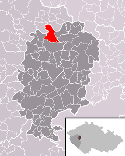 Location of Kladruby within Rokycany District | |||
 Kladruby Location of Kladruby within Czech Republic | |||
| Coordinates: 49°54′37″N 13°37′53″E / 49.91028°N 13.63139°ECoordinates: 49°54′37″N 13°37′53″E / 49.91028°N 13.63139°E | |||
| Country |
| ||
| Region | Plzeň | ||
| District | Rokycany | ||
| Area | |||
| • Total | 13.71 km2 (5.29 sq mi) | ||
| Elevation | 385 m (1,263 ft) | ||
| Population (2016-01-01) | |||
| • Total | 164 | ||
| • Density | 12/km2 (31/sq mi) | ||
| Postal code | 338 08 | ||
| Website | http://www.obec-kladruby.cz | ||

Kladruby is a village and municipality (obec) in Rokycany District in the Plzeň Region of the Czech Republic.
Kladruby covers an area of 13.71 square kilometres (5.29 sq mi), and has a population of 149 (as of 31 December 2008).
Kladruby lies approximately 19 kilometres (12 mi) north of Rokycany, 26 km (16 mi) north-east of Plzeň, and 61 km (38 mi) west of Prague.
References
| Wikimedia Commons has media related to Kladruby (Rokycany District). |
This article is issued from Wikipedia - version of the 6/5/2016. The text is available under the Creative Commons Attribution/Share Alike but additional terms may apply for the media files.