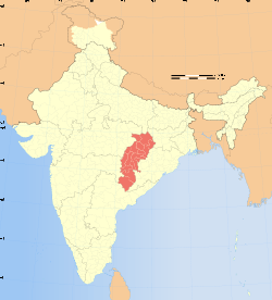
Jashpur district
| Jashpur district जशपुर जिला | |
|---|---|
| District of Chhattisgarh | |
 Location of Jashpur district in Chhattisgarh | |
| Country | India |
| State | Chhattisgarh |
| Headquarters | Jashpur Nagar |
| Tehsils | 8 |
| Government | |
| • Lok Sabha constituencies | 1 |
| • Assembly seats | 4 |
| Area | |
| • Total | 5,838 km2 (2,254 sq mi) |
| Population (2011) | |
| • Total | 851,669 |
| • Density | 150/km2 (380/sq mi) |
| Demographics | |
| • Literacy | 82% |
| • Sex ratio | 1000:1004 |
| Major highways | 1(NH-43) |
| Website | Official website |
Jashpur District lies in the north-eastern corner of the state of Chhattisgarh in India adjoining the border of Jharkhand and Odisha. Jashpur Nagar is the administrative headquarters of the district. It is currently a part of the Red Corridor.[1]
History
During the British Raj Jashpur town was the capital of Jashpur State, one of the princely states of the Eastern States Agency.[2]
Geography
The north-south length of this district is about 150 km, and its east-west breadth is about 85 km. Its total area is 6,205 km². It is between 22° 17′ and 23° 15′ North latitude and 83° 30′ and 84° 24′ East longitude.
It is divided geographically into two parts. The northern hilly belt is called the Upper Ghat. The remaining, southern part, is called Nichghat.
The upper ghat runs from Loroghat Kastura, Narayanpur, Bagicha up to the Surguja district. This belt is a forest area and contains a reserve forest. It covers the Sanna, Bagicha and Narayanpur. The upper ghat is an extension plateau covering 1384 km² which is about 1200 meters above sea level and is covered by a dense forest. The elevated plateau is called "Pat". The Upper Ghat is climbed through Loroghat. Loroghat is about 4 km in length and there are three turnings that are very dangerous.
Nichghat is flat in general but also has many big mountains. In Jashpur Raigarh road there are two more ghats, both climbing, Jhanda ghat before Kansabel and Belaghat after Kansabel.
Towns
The main towns situated on the national highway (N.H.78) are Lodam, Gholeng, and Jashpur in the Upper ghat and Kunkuri, Bandarchuwan, Kansabel, Ludeg, and Patthalgaon. The roads running from Jashpur H.Q are:
- Jashpur Ranchi.
- Jashpur Ambikapur via Manora, Kusmi (170).
- Jashpur Ambikapur via Sanna Bagicha (170 km). These 2 and 3 are not all-weather road.
- Jashpur Ambikapur via Kunkuri, patthalgaon (200 km).
- Jashpur Ambikapur via Nrayanpur Baghicha.
Climate
Kunkuri is the hottest region in Nichghat during the summer and Pandrapat is the coldest region in Upper Ghat in the winter. It is situated between forests. It is a junction, from raigarh and from ambikapur or jashpur all the people need to cross patthalgaon first.
Demographics
According to the 2011 census Jashpur district has a population of 852,043,[3] roughly equal to the nation of Qatar[4] or the US state of South Dakota.[5] This gives it a ranking of 473rd in India (out of a total of 640).[3] The district has a population density of 146 inhabitants per square kilometre (380/sq mi).[3] Its population growth rate over the decade 2001-2011 was 14.65%.[3] Jashpur has a sex ratio of 1004 females for every 1000 males,[3] and a literacy rate of 68.6%.[3]
References
- ↑ "83 districts under the Security Related Expenditure Scheme". IntelliBriefs. 2009-12-11. Retrieved 2011-09-17.
- ↑ Malleson, G. B.: An historical sketch of the native states of India, London 1875, Reprint Delhi 1984
- 1 2 3 4 5 6 "District Census 2011". Census2011.co.in. 2011. Retrieved 2011-09-30.
- ↑ US Directorate of Intelligence. "Country Comparison:Population". Retrieved 2011-10-01.
Qatar 848,016 July 2011 est.
- ↑ "2010 Resident Population Data". U. S. Census Bureau. Retrieved 2011-09-30.
South Dakota 814,180
External links
- Official website
- List of places in Jashpur
- Tribes of Jashpur District
- Tourism in Jashpur District
 |
Surguja district | Gumla district, Jharkhand |  | |
| |
Simdega district, Jharkhand | |||
| ||||
| | ||||
| Raigarh district | Sundargarh district, Odisha |
Coordinates: 22°54′N 84°09′E / 22.900°N 84.150°E
