Henderson County, Tennessee
| Henderson County, Tennessee | |
|---|---|
 Henderson County Courthouse in Lexington | |
|
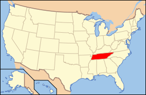
Location in the U.S. state of Tennessee | |
 Tennessee's location in the U.S. | |
| Founded | 1821 |
| Named for | James Henderson |
| Seat | Lexington |
| Largest city | Lexington |
| Area | |
| • Total | 526 sq mi (1,362 km2) |
| • Land | 520 sq mi (1,347 km2) |
| • Water | 5.8 sq mi (15 km2), 1.1% |
| Population | |
| • (2010) | 27,769 |
| • Density | 53/sq mi (20/km²) |
| Congressional district | 7th |
| Time zone | Central: UTC-6/-5 |
| Website |
hendersoncountytn |
Henderson County is a county located in the U.S. state of Tennessee. As of the 2010 census, the population was 27,769.[1] Its county seat is Lexington.[2] The county was founded in 1821 and named for James Henderson, a soldier in the War of 1812.[3]
History
Henderson County was established in 1821; it was named for Colonel James Henderson, Jr. (1775-1814), of the Tennessee State Militia, who was killed in late December 1814 below New Orleans during a clash with the British Army. Henderson is said to have served in earlier conflicts such as the Creek Indian war, which took place during the same overall time period as the War of 1812.
After the Battle of New Orleans, Major General William Carroll's Tennessee brigade, which was the largest single force under General Andrew Jackson's command in Louisiana, established their outgoing camp upriver from New Orleans and named it Camp Henderson.
General Carroll's first term as Governor of Tennessee began the same year that Henderson County was established. Perhaps it was he who proposed naming the new county after his fallen officer James Henderson.
The county seat, Lexington, was laid out in 1822.[3] Like many Tennessee counties, Henderson was divided during the Civil War. Confederate sentiment was strongest in the western half of the county (where most of the county's plantations were located), while Union support was strongest in the hilly eastern half.[3]
Geography
According to the U.S. Census Bureau, the county has a total area of 526 square miles (1,360 km2), of which 520 square miles (1,300 km2) is land and 5.8 square miles (15 km2) (1.1%) is water.[4]
The county straddles the Tennessee Valley Divide, with waters east of the divide flowing into the Tennessee River, and waters west of the divide flowing into the Mississippi River. Primary streams include the Beech River and the Forked Deer River.[3]
Adjacent counties
- Carroll County (north)
- Decatur County (east)
- Hardin County (southeast)
- Chester County (southwest)
- Madison County (west)
State protected areas
- Natchez Trace State Forest (part)
- Natchez Trace State Park (part)
Major Highways
Demographics
| Historical population | |||
|---|---|---|---|
| Census | Pop. | %± | |
| 1830 | 8,748 | — | |
| 1840 | 11,875 | 35.7% | |
| 1850 | 13,164 | 10.9% | |
| 1860 | 14,491 | 10.1% | |
| 1870 | 14,217 | −1.9% | |
| 1880 | 17,430 | 22.6% | |
| 1890 | 16,336 | −6.3% | |
| 1900 | 18,117 | 10.9% | |
| 1910 | 17,030 | −6.0% | |
| 1920 | 18,436 | 8.3% | |
| 1930 | 17,655 | −4.2% | |
| 1940 | 19,220 | 8.9% | |
| 1950 | 17,173 | −10.7% | |
| 1960 | 16,115 | −6.2% | |
| 1970 | 17,291 | 7.3% | |
| 1980 | 21,390 | 23.7% | |
| 1990 | 21,844 | 2.1% | |
| 2000 | 25,522 | 16.8% | |
| 2010 | 27,769 | 8.8% | |
| Est. 2015 | 28,015 | [5] | 0.9% |
| U.S. Decennial Census[6] 1790-1960[7] 1900-1990[8] 1990-2000[9] 2010-2014[1] | |||

As of the census[11] of 2000, there were 25,522 people, 10,306 households, and 7,451 families residing in the county. The population density was 49 people per square mile (19/km²). There were 11,446 housing units at an average density of 22 per square mile (8/km²). The racial makeup of the county was 90.45% White, 8.00% Black or African American, 0.13% Native American, 0.14% Asian, 0.01% Pacific Islander, 0.33% from other races, and 0.94% from two or more races. 0.97% of the population were Hispanic or Latino of any race.
There were 10,306 households out of which 32.30% had children under the age of 18 living with them, 56.90% were married couples living together, 11.70% had a female householder with no husband present, and 27.70% were non-families. 24.90% of all households were made up of individuals and 10.70% had someone living alone who was 65 years of age or older. The average household size was 2.44 and the average family size was 2.90.
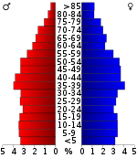
In the county, the population was spread out with 24.30% under the age of 18, 8.70% from 18 to 24, 28.80% from 25 to 44, 23.90% from 45 to 64, and 14.20% who were 65 years of age or older. The median age was 37 years. For every 100 females there were 92.90 males. For every 100 females age 18 and over, there were 90.00 males.
The median income for a household in the county was $32,057, and the median income for a family was $38,475. Males had a median income of $28,598 versus $21,791 for females. The per capita income for the county was $17,019. About 9.20% of families and 12.40% of the population were below the poverty line, including 14.60% of those under age 18 and 14.50% of those age 65 or over.
Transportation
The Beech River Regional Airport is a public-use airport located five nautical miles northwest (5.8 mi, 9.3 km) northwest of the central business district of Parsons, a city in Decatur County. The airport is located in Darden, Tennessee.
Communities
City
- Lexington (county seat)
- Parkers Crossroads
Town
- Sardis
- Scotts Hill (partial)
Census-designated place
Unincorporated communities
See also
References
- 1 2 "State & County QuickFacts". United States Census Bureau. Retrieved December 2, 2013.
- ↑ "Find a County". National Association of Counties. Retrieved 2011-06-07.
- 1 2 3 4 5 W.C. Crooks, "Henderson County," Tennessee Encyclopedia of History and Culture. Retrieved: 17 October 2013.
- ↑ "2010 Census Gazetteer Files". United States Census Bureau. August 22, 2012. Retrieved April 5, 2015.
- ↑ "County Totals Dataset: Population, Population Change and Estimated Components of Population Change: April 1, 2010 to July 1, 2015". Retrieved July 2, 2016.
- ↑ "U.S. Decennial Census". United States Census Bureau. Retrieved April 5, 2015.
- ↑ "Historical Census Browser". University of Virginia Library. Retrieved April 5, 2015.
- ↑ Forstall, Richard L., ed. (March 27, 1995). "Population of Counties by Decennial Census: 1900 to 1990". United States Census Bureau. Retrieved April 5, 2015.
- ↑ "Census 2000 PHC-T-4. Ranking Tables for Counties: 1990 and 2000" (PDF). United States Census Bureau. April 2, 2001. Retrieved April 5, 2015.
- ↑ Based on 2000 census data
- ↑ "American FactFinder". United States Census Bureau. Retrieved 2011-05-14.
External links
| Wikimedia Commons has media related to Henderson County, Tennessee. |
- Official site
- Henderson County Chamber of Commerce
- Henderson County, TNGenWeb - free genealogy resources for the county
- Henderson County at DMOZ
 |
Carroll County |  | ||
| Madison County | |
Decatur County | ||
| ||||
| | ||||
| Chester County | Hardin County |
Coordinates: 35°39′N 88°23′W / 35.65°N 88.39°W