Ambérieux-en-Dombes
| Ambérieux-en-Dombes | ||
|---|---|---|
|
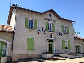
The Town Hall | ||
| ||
 Ambérieux-en-Dombes | ||
|
Location within Auvergne-Rhône-Alpes region  Ambérieux-en-Dombes | ||
| Coordinates: 45°59′57″N 4°54′12″E / 45.9992°N 4.9033°ECoordinates: 45°59′57″N 4°54′12″E / 45.9992°N 4.9033°E | ||
| Country | France | |
| Region | Auvergne-Rhône-Alpes | |
| Department | Ain | |
| Arrondissement | Bourg-en-Bresse | |
| Canton | Saint-Trivier-sur-Moignans | |
| Intercommunality | Dombes-Saône Vallée | |
| Government | ||
| • Mayor (2014–2020) | Pierre Pernet | |
| Area1 | 15.92 km2 (6.15 sq mi) | |
| Population (2009)2 | 1,616 | |
| • Density | 100/km2 (260/sq mi) | |
| Time zone | CET (UTC+1) | |
| • Summer (DST) | CEST (UTC+2) | |
| INSEE/Postal code | 01005 / 01330 | |
| Elevation |
265–302 m (869–991 ft) (avg. 300 m or 980 ft) | |
|
1 French Land Register data, which excludes lakes, ponds, glaciers > 1 km² (0.386 sq mi or 247 acres) and river estuaries. 2 Population without double counting: residents of multiple communes (e.g., students and military personnel) only counted once. | ||
Ambérieux-en-Dombes (pronounced [ɑ̃.be.ʁjø.ɑ̃.dɔ̃b]) is a French commune in the department of Ain in the Auvergne-Rhône-Alpes region of eastern France.
The inhabitants of the commune are known as Ambarrois or Ambarroises[1]
Geography
As its name suggests, Ambérieux-en-Dombes is a part of the Dombes country in Ain. It is located some 10 km east of Villefranche-sur-Saone and 35 km north of Lyon. There are several access roads to the commune: the D904 comes from Savigneux in the west through the heart of the commune and the town and continues east to Lapeyrouse; the D66 road from Saint-Trivier-sur-Moignans in the north passes through the town and continues south to Saint-Jean-de-Thurigneux; the D660 comes from Rancé in the south-west to the town; and the D82 comes from Monthieux in the south-east and continues to Chatillon-sur-Chalaronne in the north-east. All of these roads intersect in or very near the town.[2]
There is a network of country roads covering the commune which is entirely farmland outside the built-up areas. Apart from the town there is the hamlet of La Jonchay to the north-east of the town.
There are many étangs or ponds in the commune, particularly in the east but almost no waterways.[2]
Neighbouring communes and villages[2]
 |
Villeneuve | Saint-Trivier-sur-Moignans | Sainte-Olive |  |
| Savigneux | |
Villars-les-Dombes | ||
| ||||
| | ||||
| Rancé | Monthieux | Lapeyrouse |
History
The village was known as Ambariacum in the 6th century and the land belonged to the castles of the first Burgundian kings.
On 13 July 1922 a train of the Compagnie des Tramways de l'Ain returning pilgrims from Ars-sur-Formans derailed between Ambérieux-en-Dombes and Lapeyrouse leaving one dead and several injured.[3]
Heraldry
 |
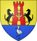
The official emblem is still to be determined.
Blazon: |
Administration
List of Successive Mayors of Ambérieux-en-Dombes [5]
| From | To | Name | Party | Position |
|---|---|---|---|---|
| 1995 | 2001 | Jean Giroux | ||
| 2001 | 2014 | Bernard Ravoire | ||
| 2014 | 2020 | Pierre Pernet |
(Not all data is known)
Demography
In 2010 the commune had 1,616 inhabitants. The evolution of the number of inhabitants is known through the population censuses conducted in the town since 1793. From the 21st century, a census of municipalities with fewer than 10,000 inhabitants is held every five years, unlike larger towns that have a sample survey every year.[Note 1]
| 1793 | 1800 | 1806 | 1821 | 1831 | 1836 | 1841 | 1846 | 1851 |
|---|---|---|---|---|---|---|---|---|
| 553 | 637 | 390 | 654 | 644 | 652 | 650 | 755 | 744 |
| 1856 | 1861 | 1866 | 1872 | 1876 | 1881 | 1886 | 1891 | 1896 |
|---|---|---|---|---|---|---|---|---|
| 737 | 818 | 887 | 823 | 848 | 879 | 882 | 862 | 852 |
| 1901 | 1906 | 1911 | 1921 | 1926 | 1931 | 1936 | 1946 | 1954 |
|---|---|---|---|---|---|---|---|---|
| 835 | 805 | 805 | 698 | 690 | 618 | 593 | 625 | 570 |
| 1962 | 1968 | 1975 | 1982 | 1990 | 1999 | 2006 | 2007 | 2008 |
|---|---|---|---|---|---|---|---|---|
| 588 | 627 | 756 | 848 | 1,156 | 1,408 | 1,436 | 1,544 | 1,567 |
| 2009 | 2010 | - | - | - | - | - | - | - |
|---|---|---|---|---|---|---|---|---|
| 1,592 | 1,616 | - | - | - | - | - | - | - |
Sources : Ldh/EHESS/Cassini until 1962, INSEE database from 1968 (population without double counting and municipal population from 2006)

Culture and heritage
Sites and monuments

- The Chateau of Ambérieux-en-Dombes (15th century)
 is registered as an historical monument.[6] It was built between 1370 and 1376 (dendrochronological study) during the reign of Humbert V of Thoire and Villars. It is located in the centre of the village today and still has four towers - three square towers 19 metres tall and a round tower of small diameter which served as a prison. The dungeon has been completely restored with the installation of a new roof in 2010.[7]
 - The War Memorial has the feature of being topped by a rooster.
-
The War Memorial.
-
Door to the Castle.
-
View of the Village Church.
-
Ruins of the Castle
-

Historical monument plaque on the Chateau
Notable people linked to the commune
- Laurent Capponi (1512-1573), Lord of Ambérieux-en-Dombes
- Jean Saint-Cyr (1899-1990), French politician, born in Ambérieux-en-Dombes
- Gundobad, the 6th-century king of the Burgundians, born in the commune
See also
External links
- Ambérieux-en-Dombes on the La Dombes website (French)
- Ambérieux-en-Dombes official website (French)
- Ambérieux-en-Dombes on Lion1906
- Ambérieux-en-Dombes on Google Maps
- Ambérieux-en-Dombes on Géoportail, National Geographic Institute (IGN) website (French)
- Amberieux en Dombe on the 1750 Cassini Map
- Ambérieux-en-Dombes on the INSEE website (French)
- INSEE (French)
Notes and references
Notes
- ↑ At the beginning of the 21st century, the methods of identification have been modified by law No. 2002-276 of 27 February 2002 , the so-called "law of local democracy" and in particular Title V "census operations" which allow, after a transitional period running from 2004 to 2008, the annual publication of the legal population of the different French administrative districts. For municipalities with a population greater than 10,000 inhabitants, a sample survey is conducted annually, the entire territory of these municipalities is taken into account at the end of the period of five years. The first "legal population" after 1999 under this new law came into force on 1 January 2009 and was based on the census of 2006.
References
- ↑ Inhabitants of Ain (French)
- 1 2 3 Google Maps
- ↑ La Presse of 15 July 1922, p. 1.
- ↑ Article Ambérieux-en-Dombes on the Blazon Bank
- ↑ The Mayors of Ambérieux-en-Dombes, consulted on 23 June 2010. (French)
- ↑ Ministry of Culture, Mérimée PA00116290 Chateau of Ambérieux-en-Dombes (French)

- ↑ The Castle on the Town Hall website of Ambérieux
| Wikimedia Commons has media related to Ambérieux-en-Dombes. |
