Zagórze Śląskie
| Zagórze Śląskie | |
|---|---|
| Village | |
|
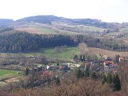
Zagórze Śląskie from Grodno castle | |
 Zagórze Śląskie | |
| Coordinates: 50°45′N 16°24′E / 50.750°N 16.400°E | |
| Country |
|
| Voivodeship | Lower Silesian |
| County | Wałbrzych |
| Gmina | Walim |
.jpg)
Zagórze Śląskie [zaˈɡuʐɛ ˈɕlɔ̃skʲɛ] (German: Kynau) is a village in the administrative district of Gmina Walim, within Wałbrzych County, Lower Silesian Voivodeship, in south-western Poland.[1]

The settlement within the northern Owl Mountains lies approximately 7 kilometres (4 mi) north-west of Walim, 10 kilometres (6 mi) south-east of Wałbrzych, and 62 kilometres (39 mi) south-west of the regional capital Wrocław.
History
Zagórze Śląskie arouse at the foot of Grodno Castle (Kynsburg) built in the late 13th century by Duke Bolko I the Strict as a fortress near the border with the Kingdom of Bohemia. After it had fallen to the Bohemian crown in 1368 it was held as a fief by various possessors, among them the Counts of Hoberg at Książ until 1567 and Prince Michael the Brave of Wallachia.
Before 1945 the area was part of Germany. After World War II the region was placed under Polish administration and ethnically cleansed according to the post-war Potsdam Agreement. The native German populace was expelled and replaced with Poles.
Sights
- Grodno Castle
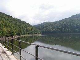
- Dam on Lubachowskie Lake
- Church, mentioned in 1376, existing from approx 1550
Walking routes
- Green: "Szlak Zamków Piastowskich" to Grodziec Castle
- Yellow: PKP Wałbrzych Główny – Nowy Dwór Castle – Jedlina-Zdrój – Niedźwiedzica – Zagórze Śląskie – Zamek Grodno – Bystrzyca Górna – Świdnica – Ślęża – Wieżyca – PKP w Sobótce – Wrocław
- Blue: European walking route E3 Spain – Bulgaria
References
- ↑ "Central Statistical Office (GUS) – TERYT (National Register of Territorial Land Apportionment Journal)" (in Polish). 1 June 2008.
External links
Coordinates: 50°45′N 16°24′E / 50.750°N 16.400°E

