Tyndall Range
| Tyndall Range | |
|---|---|
| The Tyndalls | |
|
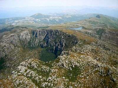
Looking south from the air, Mount Tyndall is in the foreground, Lake Tyndall in the mid-upper right, the tent like peak to rear left is Mount Sedgwick, the shadowy cliff upper right is Mount Geikie, to the left of Mount Geikie parts of Lake Margaret can be seen - the mountains in the upper portion of the photograph are continuation of the West Coast Range. | |
| Highest point | |
| Peak | Mount Tyndall |
| Elevation | 1,179 m (3,868 ft) AHD |
| Coordinates | 41°55′48″S 145°35′24″E / 41.93000°S 145.59000°E [1] |
| Geography | |
 Location in Tasmania | |
| Country | Australia |
| State | Tasmania |
| Region | Western Tasmania |
| Range coordinates | 41°56′S 145°35′E / 41.94°S 145.59°ECoordinates: 41°56′S 145°35′E / 41.94°S 145.59°E [2] |
| Parent range | West Coast Range |
| Geology | |
| Age of rock | Jurassic |
| Type of rock | Dolerite |
The Tyndall Range, commonly called The Tyndalls, is a mountain range that is part of the West Coast Range located in the Western region of Tasmania, Australia.
The main focal point for the range is Mount Tyndall which lies at the northern part of the range. The whole range western slopes can be viewed from the Anthony Road, while the plateau like formation of The Tyndalls is a road free area requiring viewing either from the air, or by foot.
Within the range lies the Tyndall Regional Reserve, a nature reserve that is the western buffer zone for the Cradle Mountain-Lake St Clair National Park World Heritage Area.[3] The area is north of Mount Sedgwick.
The Tyndalls were named in 1877 by James Reid Scott on the suggestion of Thomas Bather Moore in honour of Professor John Tyndall, a Fellow of the Geological Society who made important contributions in physics, atmospheric science and geology.[4]
Features
The Tyndall Range have a number of glacial lakes, the larger being Lake Huntley, Lake Rolleston, Lake Tyndall and Lake Matthew. The signs of the glaciation were first described by Thomas Bather Moore in 1894.[5][6][7]
The Tyndalls were explored for minerals in the early twentieth century, but no significant working mine ever eventuated.[8][9]
The Tyndalls lie south east of the Henty Gold Mine, and Hydro Tasmania dam on the upper Henty River and south of Lake Mackintosh, Lake Murchison and Tullah. They are west of the Sticht Range.
See also
References
- ↑ "Mount Tyndall (TAS)". Gazetteer of Australia online. Geoscience Australia, Australian Government.
- ↑ "Tyndall Range (TAS)". Gazetteer of Australia online. Geoscience Australia, Australian Government.
- ↑ Tyndall (Map) (2 ed.). Tasmap. 2007. Sheet 3835.
- ↑ Baillie, Peter (2010). "The West Coast Range, Tasmania: Mountains and Geological Giants" (PDF). Papers and Proceedings of the Royal Society of Tasmania (reprint ed.). Hobart, Tasmania: University of Tasmania. 144: 1–13. ISSN 0080-4703. Retrieved 18 June 2015.
- ↑ Moore, Thomas Bather (1893), Discovery of glaciation in the vicinity of mount Tyndall, in Tasmania, retrieved 21 June 2015
- ↑ "CURRENT TOPICS.". Launceston Examiner (Tas. : 1842 - 1899). Tas.: National Library of Australia. 22 June 1894. p. 4. Retrieved 9 June 2012.
- ↑ Bowden, Adrian Russell (1974), The glacial geomorphology of the Tyndall Mountains, western Tasmania, retrieved 21 June 2015
- ↑ "AN ABANDONED DISTRICT.". Examiner (Launceston, Tas. : 1900 - 1954). Launceston, Tas.: National Library of Australia. 12 March 1909. p. 2 Edition: DAILY. Retrieved 23 February 2012.
- ↑ White, Matthew J (1996), Stratigraphy, volcanology and sedimentology of the Cambrian Tyndall Group, Mount Read volcanics, western Tasmania, retrieved 21 June 2015
Further reading
- Corbett, K. D.; Jackson, J. C. (1987). "Geology of the Tyndall Range area [cartographic material]" (Map). Mt. Read Volcanics project: map. 5. 1:25,000. Hobart: Geological Survey of Tasmania, Dept. of Mines,.
- Blainey, Geoffrey (2000). The Peaks of Lyell (6th ed.). Hobart: St. David's Park Publishing. ISBN 0-7246-2265-9.
- Whitham, Charles. Western Tasmania: A Land of Riches and Beauty.
External links
- West Coast Range on Google Maps
- http://www.parks.tas.gov.au/wha/wherein/detail.html - context of World Heritage Area
