Tulkarm governorate
| |||

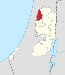
The Tulkarm governorate (Arabic: محافظة طولكرم Muḥāfaẓat Ṭūlkarm; Hebrew: נפת טולכרם Nafat Ṭūlkarm) is an administrative district and one of 16 Governorates of Palestine located in the northwestern West Bank. The governorate's land area is 268 square kilometers.[1] According to the Palestinian Central Bureau of Statistics, the governorate had a population of 172,800 inhabitants.[2] The muhfaza or district capital is the city of Tulkarm.
Localities
The Tulkarm Governorate has 51 localities and two refugee camps. The towns and cities mentioned below have populations of over 1,000.
Municipalities
Villages
| Town |
|---|
| Dhinnaba - ِِذِنّابة |
| Far'un - فرعون |
| Iktaba - إكتابا |
| 'Illar- عِلار |
| Izbat Shufa - عزبة شوفة |
| Al-Jarushiya - الجاروشية |
| Kafr Abbush - كفر عبوش |
| Kafr Jammal - كفر جمّال |
| Kafr al-Labad - كفراللبد |
| Kafr Rumman - كفر رمّان |
| Kafr Sur - كفر صور |
| Kafr Thulth - كقر ثلث |
| Kafr Zibad - كفر زيباد |
| Khureish - خربة خريش |
| Kur - كور |
| an-Nazla al-Gharbiya - النزله الغربيه |
| an-Nazla ash-Sharqiya - النزله الشرقيه |
| an-Nazla al-Wusta - النزله الوسطه |
| Nazlat Abu Nar - نزلات ابو نار |
| Nazlat 'Isa - نزلة عيسى |
| Nur Shams - مخيّم نور شمس |
| Raml Zeita - رمل زيتة/قزازة |
| Ramin |
| Ras Atiya - خربة رأس عطيّه |
| Al-Ras - الرأس |
| Saffarin - سفارين |
| Seida - صيدا |
| Shufta - شوفه |
| Sir - خربة سر |
| Zeita - زيتا |
| Shwiaka - شويكه |
See also
References
| Cities |
|  |
|---|---|---|
| Municipalities | ||
| Villages |
| |
| Refugee camps | ||
Coordinates: 32°19′11.5″N 35°5′38.5″E / 32.319861°N 35.094028°E
This article is issued from Wikipedia - version of the 10/14/2016. The text is available under the Creative Commons Attribution/Share Alike but additional terms may apply for the media files.