Santa Maria, Laguna
| Santa María | ||
|---|---|---|
| Municipality | ||
|
| ||
| ||
| Nickname(s): Rice Granary of Laguna | ||
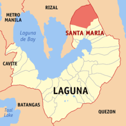
 Map of Laguna showing the location of Santa María | ||
.svg.png) Santa María Location within the Philippines | ||
| Coordinates: 14°28′12″N 121°25′34″E / 14.47000°N 121.42611°ECoordinates: 14°28′12″N 121°25′34″E / 14.47000°N 121.42611°E | ||
| Country | Philippines | |
| Region | CALABARZON (Region IV-A) | |
| Province | Laguna | |
| District | 4th district of Laguna | |
| Founded | 1602 | |
| Barangays | 25 | |
| Government | ||
| • Mayor | Antonio "Tony" Carolino | |
| Area[1] | ||
| • Total | 108.40 km2 (41.85 sq mi) | |
| Population (2010)[2] | ||
| • Total | 26,839 | |
| • Density | 250/km2 (640/sq mi) | |
| Time zone | PST (UTC+8) | |
| ZIP code | 4022 | |
| Dialing code | 49 | |
| Income class | 4th | |
Santa María is a fourth class municipality in the province of Laguna, Philippines. According to the 2010 census, it has a population of 26,839 people.[2]
Geography
Santa María, at 126 km2 is the 3rd largest town in Laguna in terms of land area, after San Pablo City and Calambâ City, followed by Lumbán. It is surrounded by the towns of Tanay (Rizal) on the north-west; Pililla (Rizal) on the west; Mabitac on the south-west, Famy on the southeast (both in Laguna); and Real (Quezon) on the north-east. It is the northernmost town in Laguna.
Bounded by the provinces of Rizal and Quezon from the western portion up to the northern tip down north eastern part, the town has a mountainous terrain. With the MARILAQUE Sub-Regional Plan (Manila-Rizal-Laguna-Quezon), the municipality functions as link between the highly industrialized capital and the marine life-rich Quezon province. A 43 kilometer road network, the Marcos Highway, physically connects to the eyed site for the International Port. Silangan Railway Express 2000 (MARILAQUE Railway) is another infrastructure project proposed for implementation under the PPP Scheme.
Barangays
Santa María is politically subdivided into 25 barangays:[1]
- Adia
- Bagong Pook (Pob.)
- Bagumbayan
- Bubukal
- Cabooan
- Calangay
- Cambuja
- Coralan
- Cueva
- Inayapan
- José Laurel, Sr.
- Kayhakat (Pob.)
- Macasipac
- Masinao
- Mataling-Ting
- Paoo
- Parang Ng Buho
- Barangay I (Pob.)
- Barangay II (Pob.)
- Barangay III (Pob.)
- Barangay IV (Pob.)
- Jose Rizal (Pob.)
- Santiago
- Talangka
- Tungkod
History
From Mabitac was a mountain path pointed northward leading to a village called Caboan. On this path near the village gateway gathers people and Chinese merchants selling and buying wares, livestock and other farm produce. Aetas sell their herbs, medicinal rootstocks, and wild honey. Women from Mabitac trade chickens with clay pots, pandan mats, and sabutan hats. It was a market place.
Caboan came from the Tagalog word “Kabuhuan,” which means bamboo thicket. “Buho,” is a genus of bamboo, which grows abundantly in the village. Caboan is a miracle of nature. Rare orchids and wild flowers decorated its forests. Its falls called “Ambon-ambon” located in one corner of the village looks like a stair of giant rocks going up to heaven. Its Nilubugan River was rich in exquisite white rocks and stones and its crystal-clear water seems to drift to nowhere.
This village used to be a part of the province of Morong. Padre Antonio de la Llave was the first parish priest of Caboan. Residents believe that he was the one responsible for making the village a town and in renaming it into San Miguel de Caboan in 1602.
A legend tells the story of how San Miguel de Caboan became Santa María. The story says that a couple going home from the market place after trading their vegetable harvest with their basic needs, found lying on the ground an image of the blessed virgin. At first, they thought it was a porcelain piece dropped by a Chinese merchant. Porcelain was a very expensive commodity during the period as it is today. After careful examination, they recognized the image as that of the Virgin Mary. The couple made an altar in their house and enthroned the image there.
The next morning the couple was astonished. The image was gone. They looked for the image all over, until they decided to look at the place where they found it. They saw a group of women, poking with a long stick something on the ground that looked like a piece of ivory. It was the image of the Virgin. It was back at the very spot where they found it.
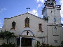
In 1613, Padre Geronimo Vásquez built the first church on the spot where the couple found the image of the Virgin. Thus, San Miguel de Cabuoan became Santa María de los Ángeles, in short — Sta. María. The Chinese uprising in 1639 destroyed the church. Parishioners rebuilt it in 1669, before the earthquake of 1880 leveled it again to the ground. Padre Leopoldo Arellano raised it once more in 1891. The church is still surviving and is now known as the Nuestra Señora delos Angeles Parish Church.
Demographics
| Population census of Santa Maria | ||
|---|---|---|
| Year | Pop. | ±% p.a. |
| 1990 | 20,525 | — |
| 1995 | 22,296 | +1.56% |
| 2000 | 24,574 | +2.11% |
| 2007 | 26,267 | +0.92% |
| 2010 | 26,839 | +0.79% |
| Source: National Statistics Office[2] | ||

Local government
Elected officials (2013 elections):
- Mayor: Atty. Ma. Rocelle V. Carolino
- Vice-Mayor: Virginia Nipay- Tuazon
- Councilors:
- Edward Requitud
- Mark Allan Real
- Alejandro Aguja
- Mario Palicpic Jr.
- Christened Jayson Cuento
- Atty. Norlito "Nor" Briones
- Honorio Landicho
- Anselmo Cordova
Educational institutions
- Santa María Academy
- Santa María National High School - Main
- Gaudencio Octavio National High School(Formerly Bagumbayan Annex)
- Santa María National High School - J. Santiago Annex
- Santa María National High School - Calangay Annex
- Our Lady of Los Ángeles School
- Adia Elementary School
- Bagong Pook Elementary School
- Bagumbayan Elementary School
- Cabooan Elementary School
- Calañgay Elementary School
- Cambuja-Bubucal Elementary School
- Coralan Elementary School
- Cueva Elementary School
- J. Santiago Elementary School
- J.P.Laurel Elementary School
- Macasipac Elementary School
- Matalinting Elementary School
- New Little Baguio Elementary School
- Paang Bundok Elementary School
- Paoo Elementary School
- Parang Ng Buho Elementary School
- Pulóng Mindanáo Elementary School
- Talangka Elementary School
- Tungkod Elementary School
- Santa María Elementary School
References
- 1 2 "Province: LAGUNA". PSGC Interactive. Makati City, Philippines: National Statistical Coordination Board. Retrieved 20 November 2013.
- 1 2 3 "Total Population by Province, City, Municipality and Barangay: as of May 1, 2010" (PDF). 2010 Census of Population and Housing. National Statistics Office. Retrieved 20 November 2013.
External links
| Wikimedia Commons has media related to Santa Maria, Laguna. |
- Official Website of Laguna Government
- unescap.org
- Philippine Standard Geographic Code
- Philippine Census Information
- Local Governance Performance Management System
 |
Tanay, Rizal | |
Real, Quezon |  |
| |
||||
| ||||
| | ||||
| Pililla, Rizal | Mabitac | Famy |

