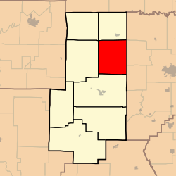
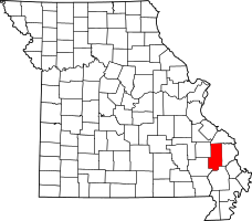
Scopus Township, Bollinger County, Missouri
| Scopus Township | |
|---|---|
| Township | |
 | |
| Coordinates: 37°26′02″N 089°55′29″W / 37.43389°N 89.92472°WCoordinates: 37°26′02″N 089°55′29″W / 37.43389°N 89.92472°W | |
| Country | United States |
| State | Missouri |
| County | Bollinger |
| Area | |
| • Total | 62.53 sq mi (161.96 km2) |
| • Land | 62.53 sq mi (161.96 km2) |
| • Water | 0 sq mi (0 km2) 0% |
| Elevation[1] | 591 ft (180 m) |
| Population (2010) | |
| • Total | 1,518 |
| • Density | 24.28/sq mi (39.07/km2) |
| FIPS code | 29-66314[2] |
| GNIS feature ID | 0766325 |
Scopus Township is one of eight townships in Bollinger County, Missouri, USA. As of the 2000 U.S. Census, its population was 1,348. As of the 2010 U.S. Census, the population had increased to 1,518. Scopus Township covers 62.53 square miles (162.0 km2).
Scopus Township was originally called German Township; the original name was changed due to Anti-German sentiment during World War I.[3]
Demographics
As of the 2010 U.S. Census, there were 1,518 people residing in the township. The population density was 24.28 people per square mile (39.07/km²). There were 654 housing units in the township. The racial makeup of the township was 98.68% White, 0.46% Black or African American, 0.33% Native American, 0.26% Asian, and 0.26% from two or more races. Approximately 0.86% of the population were Hispanic or Latino of any race.
Geography
Incorporated Areas
The township contains no incorporated settlements.
Unincorporated Areas
The township contains the unincorporated area and historical community of Scopus.
Cemeteries
The township contains the following 15 cemeteries: Ates, Bess, Burton, Chostner, Coles, Cook, Hartle, Holt, James, Judge Long, Limbaugh, Mountain View, Pulliam, and Seabaugh.
Streams
The streams of Baker Branch, Big Blue Branch, Big Hollow Branch, Bollinger Branch, Cedar Branch, Cheek Creek, Cooks Branch, Fish Branch, German Branch, Hog Creek, James Creek, Little Muddy Creek, Little Whitewater Creek, Mayfield Creek, Panther Creek, Wolf Creek, and Yantz Branch flow through Scopus Township.
Landmarks
There are no known landmarks in the township.
Administrative Districts
School Districts
- Meadow Heights R-II School District
- Woodland R-IV School District
Political Districts
- Missouri's 8th Congressional District
- State House District 145
- State Senate District 27
References
- ↑ "US Board on Geographic Names". United States Geological Survey. 2007-10-25. Retrieved 2008-01-31.
- ↑ "American FactFinder". United States Census Bureau. Retrieved 2008-01-31.
- ↑ "Bollinger County Place Names, 1928-1945 (archived)". The State Historical Society of Missouri. Retrieved 3 September 2016.
