Rousseau, Kentucky
| Rousseau, Kentucky | |
|---|---|
| Unincorporated community | |
 Rousseau, Kentucky | |
| Coordinates: 37°35′35″N 83°13′47″W / 37.59306°N 83.22972°WCoordinates: 37°35′35″N 83°13′47″W / 37.59306°N 83.22972°W | |
| Country | United States |
| State | Kentucky |
| County | Breathitt |
| Elevation | 778 ft (237 m) |
| Time zone | Eastern (EST) (UTC-5) |
| • Summer (DST) | EDT (UTC-4) |
| ZIP code | 41366 |
| Area code(s) | 606 |
| GNIS feature ID | 508980[1] |
Rousseau is an unincorporated community in Breathitt County, Kentucky. Rousseau is located on Kentucky Route 30, 8.9 miles (14.3 km) east-northeast of Jackson.[2] Rousseau had a post office until it closed on January 3, 2004; it still has its own ZIP code, 41366.[3][4]
A post office called Rousseau was established in 1882.[5] The community has the name of a mill owner.[6]
References
- ↑ "Rousseau". Geographic Names Information System. United States Geological Survey.
- ↑ State Primary Road System: Breathitt County (PDF) (Map). Kentucky Transportation Cabinet. 2012. Retrieved June 9, 2013.
- ↑ United States Postal Service (2012). "USPS - Look Up a ZIP Code". Retrieved 2012-02-15.
- ↑ "Postmaster Finder - Post Offices by ZIP Code". United States Postal Service. Retrieved June 9, 2013.
- ↑ "Breathitt County". Jim Forte Postal History. Retrieved 24 December 2015.
- ↑ Rennick, Robert M. Kentucky Place Names. University Press of Kentucky. p. 256. ISBN 0-8131-2631-2.
Municipalities and communities of Breathitt County, Kentucky, United States | ||
|---|---|---|
| City | 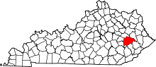 | |
| Unincorporated communities | ||
This article is issued from Wikipedia - version of the 10/13/2016. The text is available under the Creative Commons Attribution/Share Alike but additional terms may apply for the media files.