Rocklea, Queensland
| Rocklea Brisbane, Queensland | |||||||||||||
|---|---|---|---|---|---|---|---|---|---|---|---|---|---|
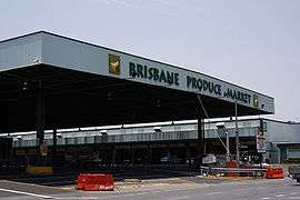
 The Brisbane Markets within the suburb | |||||||||||||
| Population | 1,255 (2011 census)[1] | ||||||||||||
| • Density | 137.9/km2 (357.2/sq mi) | ||||||||||||
| Postcode(s) | 4106 | ||||||||||||
| Area | 9.1 km2 (3.5 sq mi) | ||||||||||||
| Location | 9 km (6 mi) from Brisbane | ||||||||||||
| LGA(s) | City of Brisbane | ||||||||||||
| State electorate(s) | Yeerongpilly | ||||||||||||
| Federal Division(s) | Moreton | ||||||||||||
| |||||||||||||
Rocklea is a large suburb of Brisbane, the state capital of Queensland, Australia. The suburb is located 9 kilometres south of the city. At times the suburb has experienced significant flooding from the nearby Brisbane River. The west of the suburb is bordered by the Oxley Creek. Its tributaries, Stable Swamp Creek and Rocky Waterholes Creek, are the cause of local flooding.[2] The suburb's name is derived from the Rocky Waterholes in the area.
It is also at one end of the Ipswich Motorway and has a train station on the Beenleigh line. Ipswich Road continues north from the Ipswich Motorway, through Moorooka and into the Brisbane central business district.
Rocklea is a mostly industrial suburb, being the home to many large firms from a range industries. The suburb has a school, Rocklea State School, which was opened in 1885.[3] At the 2011 Australian Census Rocklea had a population of 1,255.[1]
History
The locality was originally called Rocky Water Holes. It was renamed Rocklea with the opening of the railway.[4] In January 1925 work commenced on the Sydney–Brisbane rail corridor.[5]
The suburbs was once the centre of the Shire of Yeerongpilly which was established in 1879 and disbanded in 1925 after the City of Brisbane was created. In 1949, Commonwealth Engineering established a railway factory in Rocklea.[6] On 31 July 2009 the last race was held at the Rocklea horse harness racing track.
Demographics
In the 2011 census, the population of Rocklea was 1,255, 45.3% female and 54.7% male. The median age of the Rocklea population was 36 years, one year below the Australian median. 60.5% of people living in Rocklea were born in Australia, which is somewhat less than the national average of 69.8%. The other top responses for country of birth were New Zealand 5.2%, England 2.5%, India 2.2%, China 1.8%, Russia 1.4%. 69.4% of people spoke only English at home; the next most popular languages were 2.9% Russian, 2.8% Vietnamese, 2.1% Mandarin, 1.8% Tamil, 1.7% Arabic. The most common religious affiliation was "no religion" (25%), followed by Catholic (22%) and Anglican (10%).[1]
Fruit and vegetable market
Rocklea is also the host to the Brisbane Markets, which is known for its flowers, fresh fruit and fresh vegetables. The current markets were established in 1964.[3] The opening of the markets occurred on 31 August and was attended by the then Premier of Queensland, Frank Nicklin.[7] The markets occupy an 100 hectare site.
The first market in the area opened in 1866 and then closed in 1881.[8] Roma Street Markets closer to the city were operational for a number of decades until congestion forced a move for the markets back to the suburbs in the 1960s.
Industry
The suburb is predominately zoned for industrial land uses. Many of the companies situated in Rocklea are part of the transport sector, with the proximity to Archerfield Airport being a drawcard. The Rocklea Works of English Electric built diesel-electric locomotives for several operators including the Queensland Railways 1600 class and successor classes.
DuluxGroup's main paint manufacturing facility is located in the suburb.[9]
Flooding
Rocklea is one of Brisbane's most flood affected suburbs. Severe damage was experienced in both the 1974 Brisbane flood and 2010–2011 Queensland floods. Flooding in Rocklea is particularly harmful to the coastal ecosystem because of the oil and other toxic chemicals which are washed downstream.[10] The effect of flooding on the Brisbane Markets was minor in 1974 but since then the site has grown five times and in 2011 35 buildings were inundated.[8]
After the 2011 flood, home and land values in the suburb decreased dramatically. The median house price decreased by 23.9%.[11]
References
- 1 2 3 Australian Bureau of Statistics (31 October 2012). "Rocklea (State Suburb)". 2011 Census QuickStats. Retrieved 22 September 2012.
- ↑ "Rocklea recent creek flood information". Brisbane City Council. 16 September 2011. Retrieved 22 September 2012.
- 1 2 "Rocklea". ourbrisbane.com via the Wayback Machine. Brisbane City Council. 10 April 2010. Retrieved 20 March 2011.
- ↑ "NOMENCLATURE OF QUEENSLAND— 252". The Courier-Mail. 21 July 1936. p. 12.
- ↑ Buchanan, Robyn (1999). Logan : rich in history, young in spirit (PDF). Logan City Council. p. 75. Retrieved 6 December 2015.
- ↑ Dunn, John C. (2006). Comeng 1: 1921 to 1955 - Volume 1 of Comeng: A History of Commonwealth Engineering. Rosenberg Publishing. p. 297. ISBN 1877058424. Retrieved 10 May 2014.
- ↑ "Brisbane Markets Limited: History". Brisbane Markets Limited. Archived from the original on 18 February 2011. Retrieved 20 March 2011.
- 1 2 "History". Brisbane Markets. Retrieved 22 September 2012.
- ↑ "Dulux says Rocklea still out of action". Sydney Morning Herald. Fairfax Media. 20 January 2011. Retrieved 22 September 2012.
- ↑ Sean Baumgart (15 January 2011). "Rocklea devastation a double blow". Brisbane Times. Fairfax Media. Retrieved 22 September 2012.
- ↑ Bridie Jabour (11 January 2011). "Frankly, property isn't dear because no-one promised a dam". Brisbane Times. Fairfax Media. Retrieved 22 September 2012.
External links
| Wikimedia Commons has media related to Rocklea, Queensland. |
Coordinates: 27°32′53″S 153°00′18″E / 27.548°S 153.005°E