Pozantı
| Pozantı | |
|---|---|
 Pozantı | |
| Coordinates: 37°25′40″N 34°52′16″E / 37.42778°N 34.87111°ECoordinates: 37°25′40″N 34°52′16″E / 37.42778°N 34.87111°E | |
| Country |
|
| Province | Adana |
| Government | |
| • Mayor | Mustafa Çay (MHP) |
| • Kaymakam | Bülent Karacan |
| Area[1] | |
| • District | 793.33 km2 (306.31 sq mi) |
| Population (2012)[2] | |
| • Urban | 9,955 |
| • District | 19,812 |
| • District density | 25/km2 (65/sq mi) |
| Website |
www |
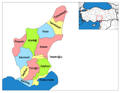
Pozantı (Ancient Greek: Πενδοσις, Pendhòsis, formerly Arab: El Bedendum) is a town and a district in the Adana Province of Turkey. The town is the at the highlands of Çukurova, and is the major gateway to the Mediterranean coasts. Pozantı stands in the foothills, at the bottom of a rare pass through these high mountains. The mayor is Mustafa Çay (MHP).
History
Pozantı has had a number of names. In antiquity it was Pendonsis or Pendosis. To the Arabs El Bedendum and finally Bozantı and Pozantı in Turkish.
Standing at the entrance to a pass across the Taurus Mountains, Pendonsis was a city of strategic importance, the gateway between the high plain of Anatolia and the low plain of Cilicia or Çukurova and thus the Middle East. Pozantı has successively passed though the hands of Hittites, Persians, Alexander the Great, Rome and Byzantium. In the period of the Abbasids the armies of Islam moved through. And then following the Battle of Manzikert in 1071 the Turks made took over. During the Crusades, control of the pass was returned to the Byzantines, then the Armenian Kingdom of Cilicia, the Mamluks and was finally brought under Ottoman control by Selim I in his campaign of 1517.
Pozantı is windy and bleak and for most of this history was a fort and a road-house, but when the railway was put through in 1917 more people began to live here permanently. But still the place really lives from the passing trade on the road.
Pozantı was briefly occupied by French forces at the end of World War I.
Pozantı today
For many Pozantı is a place to have a break after the hard journey across the Taurus. At the spring of Şekerpınar, where there is a plant for bottling the spring water, there are motels and well-known roadside restaurants specialising in barbecued meats. For many stopping here to relax on a carpeted bench grilling large quantities of lambchops or shish kebab is an essential part of the journey to Adana. Especially if you've come all the way over the mountains dodging around slow-moving trucks. (oh and the river trout is delicious too).
As the road from the city is a modern motorway Pozantı is the easiest retreat from the city of Adana, residents drive up here to picnic and escape from the summer heat.
New investment for 5 stars hotel Pendosis Vacation Club having 84 rooms and many luxury possibilities will enhance the tourism activities during the whole 12 months.
Transportation
Pozantı Gar is the railway station of Pozantı that is served by three Main Line services, connecting Pozantı to Adana, Niğde, Kayseri, Ankara and Karaman.
As being the gateway to Çukurova, Pozantı is a stopover for several coach companies that serves from Central Anatolia to Çukurova and further east.
Places of interest
- The only historical building in the city centre is the mosque and fountain of Ottoman general Cemal Paşa, built in 1919 (and since repaired and extended).
- At the entrance to the pass are the old and new castles of Anahşa.
- On the hill called Tekir, next to the modern highway
 , the Casemates of İbrahim Pasha, the remains of a 19th-century fort are situated.
 - Near the village of Aşçıbekirli lie the ruins of the Byzantine town of Fenese.
- More ruins have been found near the village of Kamışlı in the high meadows (yayla) of Ören and Asar.
See also
References
- ↑ "Area of regions (including lakes), km²". Regional Statistics Database. Turkish Statistical Institute. 2002. Retrieved 2013-03-05.
- ↑ "Population of province/district centers and towns/villages by districts - 2012". Address Based Population Registration System (ABPRS) Database. Turkish Statistical Institute. Retrieved 2013-02-27.
