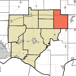
Pigeon Township, Warrick County, Indiana
| Pigeon Township | |
|---|---|
| Township | |
 Location in Warrick County | |
| Coordinates: 38°10′02″N 87°04′53″W / 38.16722°N 87.08139°WCoordinates: 38°10′02″N 87°04′53″W / 38.16722°N 87.08139°W | |
| Country | United States |
| State | Indiana |
| County | Warrick |
| Government | |
| • Type | Indiana township |
| Area | |
| • Total | 40.58 sq mi (105.1 km2) |
| • Land | 40.47 sq mi (104.8 km2) |
| • Water | 0.11 sq mi (0.3 km2) 0.27% |
| Elevation | 410 ft (125 m) |
| Population (2010) | |
| • Total | 979 |
| • Density | 24.2/sq mi (9.3/km2) |
| ZIP codes | 47523, 47541, 47637 |
| GNIS feature ID | 0453733 |
Pigeon Township is one of ten townships in Warrick County, Indiana, United States. As of the 2010 census, its population was 979 and it contained 436 housing units.[1]
History
Pigeon Township was created out of Owen Township in September 1849.[2] The township derives its name from the Little Pigeon River.[3]
Geography
According to the 2010 census, the township has a total area of 40.58 square miles (105.1 km2), of which 40.47 square miles (104.8 km2) (or 99.73%) is land and 0.11 square miles (0.28 km2) (or 0.27%) is water.[1]
Unincorporated towns
- Heilman at 38°09′27″N 87°05′25″W / 38.157551°N 87.090278°W
- Loafers Station at 38°07′32″N 87°07′05″W / 38.125606°N 87.118057°W
- Selvin at 38°12′15″N 87°06′22″W / 38.204218°N 87.106112°W
(This list is based on USGS data and may include former settlements.)
Adjacent townships
- Cass Township, Dubois County (northeast)
- Carter Township, Spencer County (east)
- Clay Township, Spencer County (southeast)
- Jackson Township, Spencer County (south)
- Skelton Township (southwest)
- Lane Township (west)
- Owen Township (west)
- Lockhart Township, Pike County (northwest)
Cemeteries
The township contains these five cemeteries: Avery, Bruce, Chinn, Twin and Wetherill.
School districts
- Warrick County School Corporation
Political districts
- Indiana's 8th congressional district
- State House District 74
- State Senate District 47
References
- United States Census Bureau 2007 TIGER/Line Shapefiles
- United States Board on Geographic Names (GNIS)
- IndianaMap
- 1 2 "Population, Housing Units, Area, and Density: 2010 - County -- County Subdivision and Place -- 2010 Census Summary File 1". United States Census. Retrieved 2013-05-10.
- ↑ History of Warrick, Spencer, and Perry Counties, Indiana: From the Earliest Time to the Present. Goodspeed. 1885. p. 32.
- ↑ Fortune, William (1881). Warrick and Its Prominent People: A History of Warrick County, Indiana from the Time of Its Organization and Settlement. Courier Company. p. 20.
External links
This article is issued from Wikipedia - version of the 10/19/2016. The text is available under the Creative Commons Attribution/Share Alike but additional terms may apply for the media files.