| [5] |
Name on the Register |
Image |
Date listed[6] |
Location |
City or town |
Description |
|---|
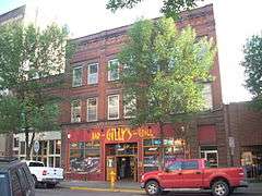
| 1 |
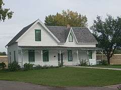
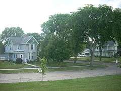
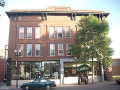
Avalon Theater |
|
000000001991-02-04-0000February 4, 1991
(#90002191) |
210 Towner Ave.
47°54′19″N 97°37′25″W / 47.905278°N 97.623611°W / 47.905278; -97.623611 (Avalon Theater) |
Larimore |
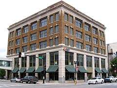
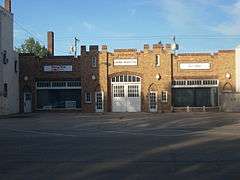
Art Deco style movie theater built in 1938 as a 350 seat theater[7]
|
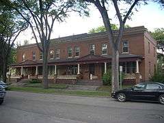
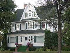
| 2 |
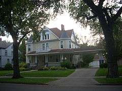
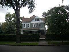
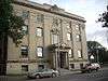
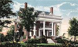
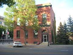
Harriet and Thomas Beare House |
|
000000001995-04-20-0000April 20, 1995
(#95000469) |
420 Reeves Dr.
47°55′04″N 97°01′36″W / 47.917778°N 97.026667°W / 47.917778; -97.026667 (Harriet and Thomas Beare House) |
Grand Forks |
Victorian house built in 1901 for real estate man Thomas Beare, exemplifying the conspicuous consumption of the cities' elite during the Progressive Era and the growth of the Second Dakota Boom.[8]
|
| 3 |
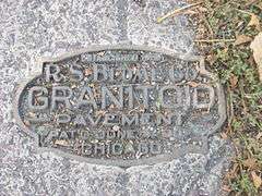
R.S. Blome Granitoid Pavement in Grand Forks |
|
000000001991-11-05-0000November 5, 1991
(#91001583) |
Roughly Lewis Boulevard south of Conklin Ave. and the area around the junctions of Walnut St. and 3rd Ave. and Minnesota Ave. and 5th St.
47°55′27″N 97°01′58″W / 47.924167°N 97.032778°W / 47.924167; -97.032778 (R.S. Blome Granitoid Pavement in Grand Forks) |
Grand Forks |
Paved area of a historic road surface, a Portland cement–aggregate combination that was intended to bridge the gap between the needs of Horse-drawn vehicles, which required sure footing, and automobiles, which needed a hard, resilient surface, in the early 1900s.[9] Boundary decreased on August 30, 2010.
|
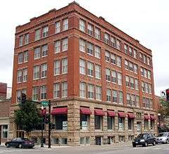
| 4 |
B'nai Israel Synagogue and Montefiore Cemetery |
|
000000002011-10-13-0000October 13, 2011
(#11000745) |
601 Cottonwood St. and 1450 N. Columbia Rd.
47°56′02″N 97°04′00″W / 47.933889°N 97.066667°W / 47.933889; -97.066667 (B'nai Israel Synagogue and Montefiore Cemetery) |
Grand Forks |
|
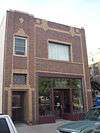
| 5 |
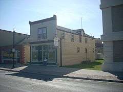
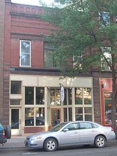
Building at 201 S. 3rd St. |
|
000000001982-10-26-0000October 26, 1982
(#82001315) |
201 S. 3rd St.
47°55′23″N 97°01′37″W / 47.922972°N 97.027083°W / 47.922972; -97.027083 (Building at 201 S. 3rd St.) |
Grand Forks |
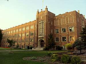
Built in 1888, "one of three frame storefront buildings in Grand Forks dating from the early period of frame construction along South Third Street, which was the original main thoroughfare in the city between 1870 and the coming of the railroad and the great Dakota Boom in the 1880s. It represents the first period of early boom town building in the city."[10] Relocated to 216 S. 3rd St. after the 1997 Red River Flood[11]
|
| 6 |
Building at 205 DeMers Ave. |
Upload image |
000000001982-10-26-0000October 26, 1982
(#82001316) |
205 DeMers Ave.
47°55′32″N 97°01′46″W / 47.925556°N 97.029444°W / 47.925556; -97.029444 (Building at 205 DeMers Ave.) |
Grand Forks |
Destroyed by the 1997 Red River Flood[12]
|
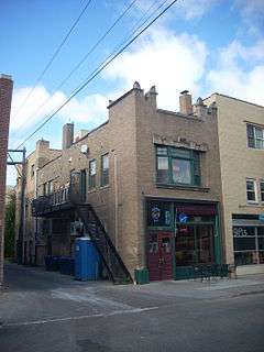
| 7 |
Building at 312 Kittson Ave. |
|
000000001982-10-26-0000October 26, 1982
(#82001317) |
312 Kittson Ave.
47°55′27″N 97°01′45″W / 47.924167°N 97.029167°W / 47.924167; -97.029167 (Building at 312 Kittson Ave.) |
Grand Forks |
|
| 8 |
Building at 317 S. 3rd St. |
Upload image |
000000001982-10-26-0000October 26, 1982
(#82001318) |
317 S. 3rd St.
47°55′21″N 97°01′30″W / 47.9225°N 97.025°W / 47.9225; -97.025 (Building at 317 S. 3rd St.) |
Grand Forks |
Destroyed by the 1997 Red River Flood[12]
|
| 9 |
Thomas D. Campbell House |
|
000000001987-09-29-0000September 29, 1987
(#87002010) |
2405 Belmont Rd.
47°53′47″N 97°01′38″W / 47.896389°N 97.027222°W / 47.896389; -97.027222 (Thomas D. Campbell House) |
Grand Forks |
Gothic Revival style log and wood frame home built in 1879, now a house museum.[13]
|
| 10 |
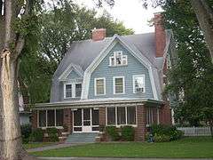
George B. Clifford House |
|
000000001986-09-30-0000September 30, 1986
(#86002655) |
406 Reeves Dr.
47°55′06″N 97°01′36″W / 47.918333°N 97.026667°W / 47.918333; -97.026667 (George B. Clifford House) |
Grand Forks |
|
| 11 |
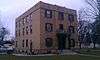
Dakota Block |
|
000000001982-10-26-0000October 26, 1982
(#82001320) |
21 S. 4th St.
47°55′26″N 97°01′48″W / 47.923889°N 97.03°W / 47.923889; -97.03 (Dakota Block) |
Grand Forks |
|
| 12 |
Joseph Bell DeRemer House |
|
000000001983-06-09-0000June 9, 1983
(#83001933) |
625 Belmont Rd.
47°54′57″N 97°01′42″W / 47.915833°N 97.028333°W / 47.915833; -97.028333 (Joseph Bell DeRemer House) |
Grand Forks |
|
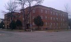
| 13 |
Dinnie Apartments |
|
000000001994-06-03-0000June 3, 1994
(#94000555) |
102-108 4th Ave., S.
47°55′07″N 97°01′33″W / 47.918611°N 97.025833°W / 47.918611; -97.025833 (Dinnie Apartments) |
Grand Forks |
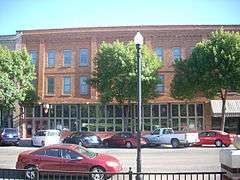
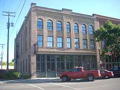
Part of Downtown Grand Forks MRA.
|
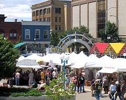
| 14 |
Downtown Grand Forks Historic District |
|
000000002005-12-28-0000December 28, 2005
(#05001475) |
Downtown Grand Forks, at the Red River of the North
47°55′35″N 97°01′51″W / 47.926389°N 97.030833°W / 47.926389; -97.030833 (Downtown Grand Forks Historic District) |
Grand Forks |
|
| 15 |
Edgar Building |
|
000000001983-04-15-0000April 15, 1983
(#83001934) |
314 Kittson Ave.
47°55′27″N 97°01′46″W / 47.924167°N 97.029444°W / 47.924167; -97.029444 (Edgar Building) |
Grand Forks |
|
| 16 |
Finks and Gokey Block |
|
000000001983-04-20-0000April 20, 1983
(#83001935) |
414-420 DeMers Ave.
47°55′27″N 97°01′55″W / 47.924167°N 97.031944°W / 47.924167; -97.031944 (Finks and Gokey Block) |
Grand Forks |
|
| 17 |
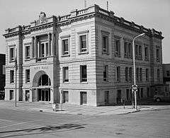
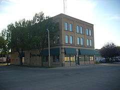
First National Bank |
|
000000001982-10-26-0000October 26, 1982
(#82001323) |
322 DeMers Ave.
47°55′29″N 97°01′52″W / 47.924722°N 97.031111°W / 47.924722; -97.031111 (First National Bank) |
Grand Forks |
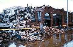
Damaged by fire during the 1997 Red River Flood. Only burned structure to survive.[14]
|
| 18 |
Carlott Funseth Round Barn |
Upload image |
000000001986-10-07-0000October 7, 1986
(#86002752) |
ND 38
47°46′46″N 97°35′56″W / 47.779444°N 97.598889°W / 47.779444; -97.598889 (Carlott Funseth Round Barn) |
Kempton |
|
| 19 |
Grand Forks City Hall |
|
000000001982-10-26-0000October 26, 1982
(#82001325) |
404 N. 2nd Ave.
47°55′33″N 97°02′03″W / 47.925833°N 97.034167°W / 47.925833; -97.034167 (Grand Forks City Hall) |
Grand Forks |
|
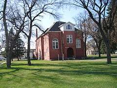
| 20 |
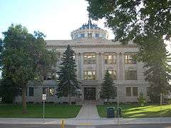
Grand Forks County Courthouse |
|
000000001980-11-25-0000November 25, 1980
(#80002913) |
S. 5th St
47°55′22″N 97°01′46″W / 47.922778°N 97.029444°W / 47.922778; -97.029444 (Grand Forks County Courthouse) |
Grand Forks |
|
| 21 |
Grand Forks County Fairgrounds WPA Structures |
|
000000002009-04-21-0000April 21, 2009
(#08001262) |
2300 Gateway Dr.
47°55′59″N 97°03′34″W / 47.933122°N 97.059483°W / 47.933122; -97.059483 (Grand Forks County Fairgrounds WPA Structures) |
Grand Forks |
|
| 22 |
Grand Forks Herald |
|
000000001982-11-30-0000November 30, 1982
(#82001326) |
120-124 N. 4th St.
47°55′33″N 97°01′58″W / 47.925833°N 97.032778°W / 47.925833; -97.032778 (Grand Forks Herald) |
Grand Forks |
Destroyed by the 1997 Red River Flood and subsequent fire.[14]
|
| 23 |
Grand Forks Mercantile Building 1898 |
|
000000002004-07-14-0000July 14, 2004
(#04000700) |
112-118 N. 3rd St.
47°55′42″N 97°01′56″W / 47.928333°N 97.032222°W / 47.928333; -97.032222 (Grand Forks Mercantile Building 1898) |
Grand Forks |
|
| 24 |
Grand Forks Mercantile Co. |
|
000000001982-10-26-0000October 26, 1982
(#82001327) |
124 N. 3rd St.
47°55′36″N 97°01′56″W / 47.926667°N 97.032222°W / 47.926667; -97.032222 (Grand Forks Mercantile Co.) |
Grand Forks |
|
| 25 |
Grand Forks Near Southside Historic District |
|
000000002004-07-28-0000July 28, 2004
(#04000757) |
Roughly bounded by ND 697, the Red River, 13th Ave., and Cottonwood St.; also 1216 Belmont Rd.
47°55′03″N 97°01′37″W / 47.9175°N 97.026944°W / 47.9175; -97.026944 (Grand Forks Near Southside Historic District) |
Grand Forks |
Belmont Road address represents a boundary increase
|
| 26 |
Grand Forks Riverside Neighborhood Historic District |
|
000000002007-11-15-0000November 15, 2007
(#07000181) |
North of U.S. Route 2 (Gateway Dr. and west of the Red River)
47°56′14″N 97°02′32″W / 47.937158°N 97.042089°W / 47.937158; -97.042089 (Grand Forks Riverside Neighborhood Historic District) |
Grand Forks |
|
| 27 |
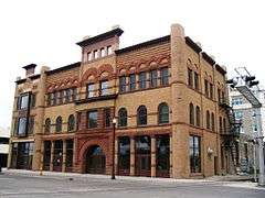
Grand Forks Woolen Mills |
|
000000001983-10-26-0000October 26, 1983
(#83001936) |
301 N. 3rd St.
47°55′38″N 97°02′02″W / 47.927222°N 97.033889°W / 47.927222; -97.033889 (Grand Forks Woolen Mills) |
Grand Forks |
|
| 28 |
Great Northern Freight Warehouse and Depot |
Upload image |
000000001990-01-29-0000January 29, 1990
(#89002031) |
899 2nd Ave., N.
47°55′15″N 97°02′15″W / 47.920833°N 97.0375°W / 47.920833; -97.0375 (Great Northern Freight Warehouse and Depot) |
Grand Forks |
|
| 29 |
Hariman Sanatorium |
|
000000002013-08-28-0000August 28, 2013
(#13000633) |
2002 University Ave.
47°55′21″N 97°03′20″W / 47.922586°N 97.055675°W / 47.922586; -97.055675 (Hariman Sanatorium) |
Grand Forks |
|
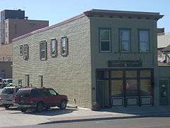
| 30 |
Hook and Ladder No. 1 and Hose Co. No. 2 |
|
000000001982-10-26-0000October 26, 1982
(#82001328) |
215 S. 4th St.
47°55′21″N 97°01′38″W / 47.9225°N 97.027222°W / 47.9225; -97.027222 (Hook and Ladder No. 1 and Hose Co. No. 2) |
Grand Forks |
|
| 31 |
House at 1648 Riverside Drive |
Upload image |
000000001994-09-02-0000September 2, 1994
(#94001074) |
1648 Riverside Dr.
47°56′09″N 97°02′11″W / 47.935833°N 97.036389°W / 47.935833; -97.036389 (House at 1648 Riverside Drive) |
Grand Forks |
|
| 32 |
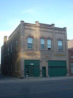
Iddings Block |
|
000000001982-10-26-0000October 26, 1982
(#82001329) |
9 N. 3rd St.
47°55′32″N 97°01′52″W / 47.925556°N 97.031111°W / 47.925556; -97.031111 (Iddings Block) |
Grand Forks |
|
| 33 |
The Kegs Drive-In |
|
000000002011-08-24-0000August 24, 2011
(#11000603) |
901 N. 5th St.
47°55′48″N 97°02′40″W / 47.93°N 97.044333°W / 47.93; -97.044333 (The Kegs Drive-In) |
Grand Forks |
|
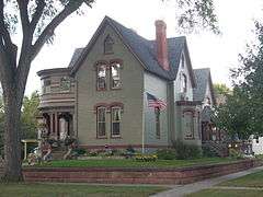
| 34 |
J. Nelson Kelly House |
|
000000001994-02-18-0000February 18, 1994
(#94000058) |
521 S. 5th St.
47°55′10″N 97°01′28″W / 47.919444°N 97.024444°W / 47.919444; -97.024444 (J. Nelson Kelly House) |
Grand Forks |
|
| 35 |
Larimore City Hall |
|
000000001990-05-31-0000May 31, 1990
(#90000600) |
Block 64, bounded by Towner, 3rd, Terry, and Main
47°54′23″N 97°37′58″W / 47.906389°N 97.632778°W / 47.906389; -97.632778 (Larimore City Hall) |
Larimore |
|
| 36 |
Martin V. Linwell House |
Upload image |
000000001980-02-28-0000February 28, 1980
(#80002914) |
316 S. Raymond St.
47°43′56″N 97°34′05″W / 47.732222°N 97.568056°W / 47.732222; -97.568056 (Martin V. Linwell House) |
Northwood |
|
| 37 |
Lyons Garage |
|
000000001982-10-26-0000October 26, 1982
(#82001330) |
214-218 N. 4th St.
47°55′35″N 97°02′03″W / 47.926389°N 97.034167°W / 47.926389; -97.034167 (Lyons Garage) |
Grand Forks |
|
| 38 |
Masonic Temple |
|
000000001982-10-26-0000October 26, 1982
(#82001331) |
413-421 Bruce Ave.
47°55′18″N 97°01′43″W / 47.921667°N 97.028611°W / 47.921667; -97.028611 (Masonic Temple) |
Grand Forks |
|
| 39 |
Metropolitan Opera House |
|
000000001999-08-27-0000August 27, 1999
(#99001048) |
116 S. 3rd St.
47°55′26″N 97°01′41″W / 47.923889°N 97.028056°W / 47.923889; -97.028056 (Metropolitan Opera House) |
Grand Forks |
|
| 40 |
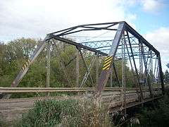
Midway Bridge |
Upload image |
000000001997-02-27-0000February 27, 1997
(#97000176) |
Unnamed county road across an unnamed creek, approximately 1.5 miles south and 2 miles west of Johnstown
48°07′50″N 97°30′50″W / 48.130556°N 97.513889°W / 48.130556; -97.513889 (Midway Bridge) |
Johnstown |
|
| 41 |
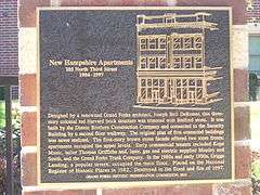
New Hampshire Apartments |
|
000000001982-10-26-0000October 26, 1982
(#82001332) |
105 N. 3rd St.
47°55′34″N 97°01′55″W / 47.926111°N 97.031944°W / 47.926111; -97.031944 (New Hampshire Apartments) |
Grand Forks |
Classically-detailed, Early Commercial building designed by Joseph DeRemer, constructed by Dinnie Brothers in 1904; destroyed by the 1997 Red River Flood,[14] A historical marker indicates that the building was destroyed in the 1997 Red River Flood and fire.
|
| 42 |
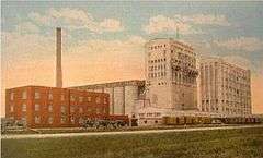
North Dakota Mill and Elevator |
|
000000001992-05-11-0000May 11, 1992
(#92000433) |
1823 Mill Rd.
47°56′21″N 97°03′21″W / 47.939167°N 97.055833°W / 47.939167; -97.055833 (North Dakota Mill and Elevator) |
Grand Forks |
|
| 43 |
Northern Pacific Depot and Freight House |
|
000000001982-10-26-0000October 26, 1982
(#82001333) |
202 N. 3rd St.
47°55′37″N 97°01′58″W / 47.926944°N 97.032778°W / 47.926944; -97.032778 (Northern Pacific Depot and Freight House) |
Grand Forks |
|
| 44 |
Northwood Bridge |
Upload image |
000000001997-02-27-0000February 27, 1997
(#97000175) |
Unnamed county road across the Goose River, 1.5 miles southwest of Northwood
47°43′03″N 97°36′25″W / 47.7175°N 97.606944°W / 47.7175; -97.606944 (Northwood Bridge) |
Northwood |
|
| 45 |
Odd Fellows Block |
|
000000001982-10-26-0000October 26, 1982
(#82001334) |
23-25 S. 4th St.
47°55′26″N 97°01′47″W / 47.923889°N 97.029722°W / 47.923889; -97.029722 (Odd Fellows Block) |
Grand Forks |
|
| 46 |
Ost Valle Bridge |
|
000000001997-02-27-0000February 27, 1997
(#97000178) |
Unnamed county road across an unnamed tributary of the Red River, approximately 6 miles east and 1 mile north of Thompson
47°47′18″N 96°58′57″W / 47.788333°N 96.9825°W / 47.788333; -96.9825 (Ost Valle Bridge) |
Thompson |
|
| 47 |
Oxford House |
|
000000001973-05-02-0000May 2, 1973
(#73001384) |
University of North Dakota campus
47°55′19″N 97°04′26″W / 47.921944°N 97.073889°W / 47.921944; -97.073889 (Oxford House) |
Grand Forks |
|
| 48 |
Roller Office Supply |
|
000000001982-10-26-0000October 26, 1982
(#82001336) |
7 N. 3rd St.
47°55′31″N 97°01′51″W / 47.925278°N 97.030833°W / 47.925278; -97.030833 (Roller Office Supply) |
Grand Forks |
|
| 49 |
St. John's Block Commercial Exchange |
|
000000001982-10-26-0000October 26, 1982
(#82001338) |
2 N. 3rd St.
47°55′32″N 97°01′49″W / 47.925556°N 97.030278°W / 47.925556; -97.030278 (St. John's Block Commercial Exchange) |
Grand Forks |
|
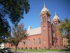
| 50 |
St. Michael's Church |
|
000000001988-06-30-0000June 30, 1988
(#88000983) |
520 N. 6th St.
47°55′37″N 97°02′21″W / 47.926944°N 97.039167°W / 47.926944; -97.039167 (St. Michael's Church) |
Grand Forks |
|
| 51 |
St. Michael's Hospital and Nurses' Residence |
|
000000001995-04-20-0000April 20, 1995
(#95000468) |
813 Lewis Boulevard
47°55′57″N 97°02′22″W / 47.9325°N 97.039444°W / 47.9325; -97.039444 (St. Michael's Hospital and Nurses' Residence) |
Grand Forks |
|
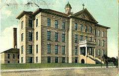
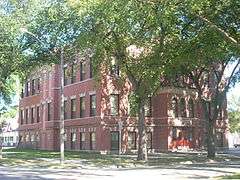
| 52 |
St. Michael's Parochial School |
Upload image |
000000002016-07-18-0000July 18, 2016
(#16000457) |
504 N. 5th Ave.
47°55′39″N 97°02′23″W / 47.927517°N 97.039780°W / 47.927517; -97.039780 (St. Michael's Parochial School) |
Grand Forks |
|
| 53 |
Skarsbo Apartments |
|
000000002013-08-27-0000August 27, 2013
(#13000634) |
204 & 210 N. 6th St.
47°55′29″N 97°02′10″W / 47.924711°N 97.036099°W / 47.924711; -97.036099 (Skarsbo Apartments) |
Grand Forks |
|
| 54 |
Sorlie Memorial Bridge |
|
000000001999-07-19-0000July 19, 1999
(#99000844) |
Eastern end of Demers Ave.
47°55′37″N 97°01′40″W / 47.926944°N 97.027778°W / 47.926944; -97.027778 (Sorlie Memorial Bridge) |
Grand Forks |
|
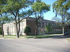
| 55 |
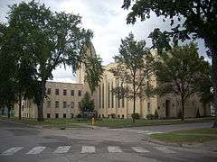
South Junior High School |
|
000000001999-03-05-0000March 5, 1999
(#99000274) |
1224 Walnut St.
47°54′33″N 97°01′55″W / 47.909167°N 97.031944°W / 47.909167; -97.031944 (South Junior High School) |
Grand Forks |
|
| 56 |
Speed Printing |
|
000000001982-10-26-0000October 26, 1982
(#82001337) |
220 S. 3rd St.
47°55′23″N 97°01′35″W / 47.923056°N 97.026389°W / 47.923056; -97.026389 (Speed Printing) |
Grand Forks |
|
| 57 |
Stratford Building |
|
000000001982-10-26-0000October 26, 1982
(#82001339) |
311 DeMers Ave.
47°55′29″N 97°01′50″W / 47.924722°N 97.030556°W / 47.924722; -97.030556 (Stratford Building) |
Grand Forks |
|
| 58 |
Telephone Co. Building |
|
000000001982-10-26-0000October 26, 1982
(#82001340) |
24 N. 4th St.
47°55′31″N 97°01′55″W / 47.925278°N 97.031944°W / 47.925278; -97.031944 (Telephone Co. Building) |
Grand Forks |
|
| 59 |
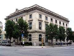
U.S. Post Office and Courthouse |
|
000000001976-06-03-0000June 3, 1976
(#76001354) |
102 N. 4th St.
47°55′32″N 97°01′57″W / 47.925556°N 97.0325°W / 47.925556; -97.0325 (U.S. Post Office and Courthouse) |
Grand Forks |
|
| 60 |
United Lutheran Church |
|
000000001991-12-30-0000December 30, 1991
(#91001906) |
324 Chestnut St.
47°55′07″N 97°01′49″W / 47.918611°N 97.030278°W / 47.918611; -97.030278 (United Lutheran Church) |
Grand Forks |
|
| 61 |
University of North Dakota Historic District |
|
000000002010-01-13-0000January 13, 2010
(#08001233) |
University of North Dakota
47°55′21″N 97°04′14″W / 47.922444°N 97.070614°W / 47.922444; -97.070614 (University of North Dakota Historic District) |
Grand Forks |
|
| 62 |
Viets Hotel |
Upload image |
000000001982-10-26-0000October 26, 1982
(#82001341) |
309-311 3rd St., S.
47°55′22″N 97°01′30″W / 47.922778°N 97.025°W / 47.922778; -97.025 (Viets Hotel) |
Grand Forks |
Damaged by the 1997 Red River Flood and destroyed by fire in September 2000[15]
|
| 63 |
Washington School |
|
000000001992-02-24-0000February 24, 1992
(#92000035) |
422 N. 6th St.
47°55′34″N 97°02′18″W / 47.926111°N 97.038333°W / 47.926111; -97.038333 (Washington School) |
Grand Forks |
|
| 64 |
Wells-Denbrook Architects Office Building |
Upload image |
000000002014-11-04-0000November 4, 2014
(#14000900) |
1701 Cherry St.
47°54′13″N 97°02′08″W / 47.9037°N 97.0356°W / 47.9037; -97.0356 (Wells-Denbrook Architects Office Building) |
Grand Forks |
|
| 65 |
Dr. Henry Wheeler House |
|
000000001986-01-16-0000January 16, 1986
(#86000166) |
420 Franklin St.
47°55′13″N 97°01′33″W / 47.920278°N 97.025833°W / 47.920278; -97.025833 (Dr. Henry Wheeler House) |
Grand Forks |
|
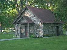
| 66 |
WPA Stone Structures in Memorial Park and Calvary Cemetery |
|
000000002010-07-06-0000July 6, 2010
(#10000424) |
Southeast corner from intersection of Gateway Dr. and N Columbia Rd.
47°55′59″N 97°04′00″W / 47.933056°N 97.066667°W / 47.933056; -97.066667 (WPA Stone Structures in Memorial Park and Calvary Cemetery) |
Grand Forks |
|
| 67 |
Wright Block |
|
000000001982-10-26-0000October 26, 1982
(#82001342) |
408-412 DeMers Ave.
47°55′28″N 97°01′54″W / 47.924444°N 97.031667°W / 47.924444; -97.031667 (Wright Block) |
Grand Forks |
|