Listed buildings in Bootle, Cumbria
Bootle is a civil parish in the Borough of Copeland, Cumbria, England. It contains twelve listed buildings that are recorded in the National Heritage List for England. Of these, two are listed at Grade II*, the middle of the three grades, and the others are at Grade II, the lowest grade. The parish contains the village of Bootle and the surrounding countryside. The listed buildings comprise houses and associated structures, churches and associated structures, a school, and a village cross.
Key
| Grade | Criteria[1] |
|---|---|
| II* | Particularly important buildings of more than special interest |
| II | Buildings of national importance and special interest |
Buildings
| Name and location | Photograph | Date | Notes | Grade |
|---|---|---|---|---|
| Seaton Hall with attached ruins 54°17′50″N 3°22′23″W / 54.29710°N 3.37294°W |
c. 1190 | The ruins are those of parts of a Benedictine nunnery. The house was built within the ruins in the 16th century, and was restored in the 19th century. The remains of the east wall of the chancel contain three Early English lancet windows; a part of the south wall also remains. The house is in stone and has a slate roof, two storeys, and a U-shaped plan. The south wing has three bays, and a central doorway with a Tudor arched head. The windows are transomed, or mullioned and transomed.[2][3] | II* | |
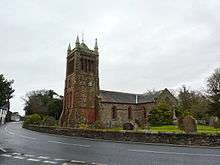
| St Michael's Church 54°17′00″N 3°22′22″W / 54.28335°N 3.37291°W |
 |
Medieval | Medieval material remains only in the chancel. Alterations, including addition of the transepts, were made in 1837. Building of the tower was started soon after 1850 and it was completed in 1882. The church is in stone, the chancel is roughcast, and the roof is slated. The church consists of a nave, transepts, a chancel with a south organ loft, and a west tower. The tower has angle buttresses, a west doorway above which are two lancet windows and a clock face, a canted stair turret to the north with a hipped roof and a small dormer, louvred bell openings, a Lombard frieze, a coped parapet with pinnacles, and a pyramidal roof with a cross.[4][5] | II |
| Sundial 54°16′59″N 3°22′23″W / 54.28317°N 3.37292°W |
— |
18th century (probable) | The sundial is in the churchyard of St Michael's Church, and stands on an earlier base. It is in ashlar stone, on three high round steps, and has a plain baluster shaft. The plate is missing.[6] | II |
| Eskmeals 54°19′45″N 3°23′59″W / 54.32918°N 3.39979°W |
— |
1761 | Additions were later made to the house, which is roughcast with ashlar dressings and slate roofs with coped gables. There are two storeys, in the centre is a three-bay block with a rear wing, to the north is a recessed two-bay extension, and to the south a lower and recessed two-bay extension with a lean-to and a single-storey service wing. The windows are sashes. In the centre is a gabled porch with angle pilasters and a doorway with a moulded surround and a pediment.[7] | II |
| Swallowhurst and barns 54°18′25″N 3°22′49″W / 54.30684°N 3.38020°W |
— |
1770 | The buildings are in stone, and consist of a house with flanking barns at right angles. The house is roughcast and has a slate roof with coped gables. It has two storeys, a central block of three bays, flanked by lower two-storey extensions. The central doorway has a porch with an elliptical head and an archivolt, and above it is a datestone. The windows are replacement casements. The barns project to the front, they have roofs of concrete tiles, the barn to the left has ventilation slits, and the other barn is roughcast.[8] | II |
| The Nook 54°18′14″N 3°23′53″W / 54.30384°N 3.39803°W |
— |
Late 18th century | A roughcast stone house with ashlar dressings, quoins, two string courses, a frieze, a cornice, and a roof of concrete tiles. There are two storeys and three bays, with a small rear wing. The central entrance has a moulded architrave, flat pilasters, and a broken pediment surmounted by an urn. The windows are 20th-century casements with plain surrounds.[9] | II |
| Shaw Monument 54°16′59″N 3°22′23″W / 54.28312°N 3.37312°W |
— |
1780 | The monument consists of a headstone, and stands by the wall in the churchyard of St Michael's Church. It is in ashlar, and has a broken segmental pediment with paterae and floral drops at the ends and on the sides, and an urn. It is inscribed with the names of three members of the Shaw family.[10] | II |
| United Reformed Church and two houses 54°16′53″N 3°22′19″W / 54.28143°N 3.37192°W |
— |
1780 | The chapel is stuccoed on a moulded plinth, with reeded pilaster strips, a cornice, and a slate roof, hipped at the east end. The east front has two storeys, a central entrance and windows, those in the upper floor round-headed. On the north front are three round-headed windows. Attached to the west are two two-storey houses, one with two bays, the other with three. They are roughcast, with sash windows, and each house has a dated lintel, the later dated 1808.[11][12] | II* |
| 3 Main Street 54°16′55″N 3°22′18″W / 54.28184°N 3.37176°W |
— |
Early 19th century | A house and shop, roughcast with ashlar dressings, in two storeys and three bays. The windows are sashes with architraves, and there is a shop window with a panelled apron, flat pilasters, a frieze, a cornice, and small panes. There are two entrances with plain surrounds; the left entrance has a tympanum with an archivolt, and the right entrance has a fanlight above the door.[13] | II |
| Captain Shaw's Primary School 54°16′55″N 3°22′19″W / 54.28181°N 3.37206°W |
 |
1830 | The school is in stuccoed stone on a moulded plinth, with quoins, a cornice, a coped parapet, and a slate roof with coped gables. There are two storeys with five bays on the front and two in the side. The windows have two lights, double-chamfered mullions, and hood moulds. On the side are two entrances with four-centred arches, and a plaque incised with biblical quotations. At the rear is a flat-roofed wing, an outshut, and a linked shed with a gable opening for a bell.[11][14] | II |
| Signal Box 54°17′29″N 3°23′39″W / 54.29143°N 3.39404°W |
 |
1874 | The signal box was built for the Furness Railway. It has a sandstone base, glazed on three sides, and has a hipped Welsh slate roof with ridge tiles. On the north side are modern external steps. Inside is a London Midland Region lever frame of 15 levers installed in 1977.[15] | II |
| Village Cross 54°16′59″N 3°22′23″W / 54.28302°N 3.37299°W |
 |
1897 | The cross stands on the site of the former market cross. Designed by Austin and Paley, it is in ashlar, and stands on three steps. The cross has a tapering base, and consists of a plain shaft and a Celtic round head. On the base is a plaque recording the Diamond Jubilee of Queen Victoria and the dates of two market charters.[11][16] | II |
References
Citations
- ↑ Historic England
- ↑ Hyde & Pevsner (2010), pp. 160–161
- ↑ Historic England (1086649)
- ↑ Hyde & Pevsner (2010), pp. 159–160
- ↑ Historic England (1086650)
- ↑ Historic England (1336051)
- ↑ Historic England (1086648)
- ↑ Historic England (1336050)
- ↑ Historic England (1336049)
- ↑ Historic England (1086651)
- 1 2 3 Hyde & Pevsner (2010), p. 160
- ↑ Historic England (1252005)
- ↑ Historic England (1336052)
- ↑ Historic England (1086609)
- ↑ Historic England (1412053)
- ↑ Historic England (1086652)
Sources
- Historic England, "Seaton Hall with attached ruins, Bootle (1086649)", National Heritage List for England, retrieved 17 July 2016
- Historic England, "Church of St Michael, Bootle (1086650)", National Heritage List for England, retrieved 17 July 2016
- Historic England, "Sundial approximately 3 metres south of St Michael's Church, Bootle (1336051)", National Heritage List for England, retrieved 17 July 2016
- Historic England, "Eskmeals, Bootle (1086648)", National Heritage List for England, retrieved 17 July 2016
- Historic England, "Swallowhurst and attached barns, Bootle (1336050)", National Heritage List for England, retrieved 17 July 2016
- Historic England, "The Nook, Bootle (1336049)", National Heritage List for England, retrieved 17 July 2016
- Historic England, "Shaw Mo1336049nument approximately 20 metres to south of Church of St Michael, Bootle (1086651)", National Heritage List for England, retrieved 17 July 2016
- Historic England, "United Reformed Church and two attached houses to east, Bootle (1252005)", National Heritage List for England, retrieved 17 July 2016
- Historic England, "House and shop opposite Captain Shaw's School, Bootle (1336052)", National Heritage List for England, retrieved 17 July 2016
- Historic England, "House and shop opposite Captain Shaw's School, Bootle (1336052)", National Heritage List for England, retrieved 17 July 2016
- Historic England, "Captain Shaw's Primary School, Bootle (1086609)", National Heritage List for England, retrieved 17 July 2016
- Historic England, "Bootle Signal Box (1412053)", National Heritage List for England, retrieved 17 July 2016
- Historic England, "Village Cross, Bootle (1086652)", National Heritage List for England, retrieved 17 July 2016
- Historic England, Listed Buildings, retrieved 17 July 2016
- Hyde, Matthew; Pevsner, Nikolaus (2010) [1967], Cumbria, The Buildings of England, New Haven and London: Yale University Press, ISBN 978-0-300-12663-1
This article is issued from Wikipedia - version of the 7/17/2016. The text is available under the Creative Commons Attribution/Share Alike but additional terms may apply for the media files.