List of listed buildings in Lesmahagow Parish, South Lanarkshire
This is a list of listed buildings in the parish of Lesmahagow in South Lanarkshire, Scotland.
List
| Name | Location | Date Listed | Grid Ref. [note 1] | Geo-coordinates | Notes | HB Number [note 2] | Image |
|---|---|---|---|---|---|---|---|
| Auchlochan Bridge | 55°37′06″N 3°53′26″W / 55.618364°N 3.890596°W | Category B | 7688 | 
| |||
| Folkerton Mill | 55°36′12″N 3°48′56″W / 55.603329°N 3.815692°W | Category B | 7695 |
| |||
| Old Lesmahagow Church, And Graveyard | 55°38′18″N 3°53′07″W / 55.638235°N 3.885325°W | Category B | 7675 |
| |||
| Craignethan Castle | 55°41′46″N 3°53′06″W / 55.696088°N 3.885006°W | Category A | 7677 | 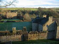
| |||
| West Hawksland | 55°38′21″N 3°49′57″W / 55.639233°N 3.832526°W | Category C(S) | 7694 |
| |||
| Birkwood, South Lodge And Gateway, New Trows Road | 55°37′45″N 3°53′40″W / 55.62917°N 3.89442°W | Category B | 7699 |
| |||
| Lesmahagow Village, Royal Bank Of Scotland Including Boundary Walls And Gatepiers | 55°38′24″N 3°53′12″W / 55.640076°N 3.886557°W | Category B | 7701 |
| |||
| Kirkmuirhill Parish Church (United Presbyterian Church) Including Railings And Church Hall | 55°39′53″N 3°54′36″W / 55.66486°N 3.909897°W | Category C(S) | 48138 |
| |||
| Turfholm Bridge | 55°38′03″N 3°53′11″W / 55.63429°N 3.886438°W | Category C(S) | 7676 |
| |||
| Corra Castle | 55°39′12″N 3°46′40″W / 55.653319°N 3.777872°W | Category A | 7680 | 
| |||
| Clydevale | 55°42′05″N 3°51′59″W / 55.701372°N 3.866259°W | Category B | 7686 |
| |||
| 81/83 Lanark Road Crossford Village | 55°41′55″N 3°52′06″W / 55.698562°N 3.868417°W | Category C(S) | 7687 |
| |||
| Birkhill, Including Stable Wing | 55°36′00″N 3°50′41″W / 55.600135°N 3.84483°W | Category B | 7692 |
| |||
| Birkwood House | 55°37′59″N 3°53′22″W / 55.632951°N 3.889344°W | Category B | 7698 |
| |||
| Auchenheath House Including Coach House, Garden Terraces And Balustrades, South Entrance Gatepiers And Walls | 55°40′15″N 3°54′00″W / 55.670882°N 3.900014°W | Category B | 51053 |
| |||
| 162 Riverside Road, Kirkfieldbank | 55°40′30″N 3°48′25″W / 55.674893°N 3.807063°W | Category C(S) | 44600 |
| |||
| Douglasmouth Bridge | 55°37′51″N 3°45′55″W / 55.630773°N 3.765334°W | Category B | 7689 |
| |||
| Stables, Harperfield | 55°38′18″N 3°45′47″W / 55.638303°N 3.762924°W | Category C(S) | 7691 |
| |||
| Lesmahagow Village, Old Roadbridge West Of Milton Road/Carlisle Junction At Ngr 8145 4054 | 55°38′38″N 3°53′06″W / 55.643927°N 3.885074°W | Category B | 7703 |
| |||
| West Toun, Coalburn, Statue Of A Highlander | 55°35′01″N 3°51′39″W / 55.583698°N 3.860861°W | Category B | 13402 |
| |||
| Lesmahagow Village, Abbeygreen Parish Church And Manse Including Boundary Walls And Gatepiers | 55°38′27″N 3°53′12″W / 55.640775°N 3.886718°W | Category B | 11729 |
| |||
| Off New Trows Road, Birkwood South Driveway Bridge | 55°37′49″N 3°53′39″W / 55.630189°N 3.894231°W | Category C(S) | 11726 |
| |||
| Dovecot, Blackwood House | 55°40′06″N 3°56′55″W / 55.668249°N 3.948701°W | Category B | 7678 |
| |||
| Corehouse, Dovecot | 55°39′13″N 3°46′54″W / 55.653659°N 3.781702°W | Category C(S) | 7681 |
| |||
| Crossford Bridge | 55°41′51″N 3°52′01″W / 55.697514°N 3.867014°W | Category B | 7684 |
| |||
| Greenrig | 55°39′34″N 3°49′09″W / 55.659375°N 3.819065°W | Category B | 7693 |
| |||
| Nos 15-19 Bereholm, Lesmahagow | 55°38′14″N 3°53′06″W / 55.637312°N 3.885121°W | Category B | 7696 |
| |||
| Lesmahagow Village, Old Bridge West Of Milton Road At Ngr Ns 8148 4044 | 55°38′35″N 3°53′04″W / 55.642992°N 3.884552°W | Category B | 7700 |
| |||
| Corehouse Conservatory And Flower Garden Walls, Gatepiers And Gates | 55°39′17″N 3°46′53″W / 55.654678°N 3.781478°W | Category B | 51595 |
| |||
| Corehouse Stable Court Including Gatepiers And Boundary Wall | 55°39′10″N 3°46′57″W / 55.652685°N 3.782596°W | Category B | 51596 |
| |||
| Corehouse, Mausoleum | 55°39′23″N 3°46′59″W / 55.65647°N 3.783117°W | Category C(S) | 7682 |
| |||
| Harperfield | 55°38′17″N 3°45′42″W / 55.638025°N 3.761625°W | Category B | 7690 |
| |||
| Stonebyres Coach House And Adjoining Buildings | 55°40′20″N 3°50′42″W / 55.672252°N 3.844979°W | Category B | 7697 |
| |||
| Corehouse Stove House (Or Vinery) | 55°39′19″N 3°46′54″W / 55.655178°N 3.781692°W | Category C(S) | 51597 |
| |||
| 185 New Trows Road, Birkwood, West Lodge | 55°38′01″N 3°53′35″W / 55.633577°N 3.893076°W | Category B | 11725 |
| |||
| Abbeygreen Road, Birkwood, Driveway Bridge Over River Nethan | 55°38′03″N 3°53′11″W / 55.63429°N 3.886438°W | Category B | 11727 |
| |||
| Birkwood, Walled Garden | 55°37′59″N 3°53′08″W / 55.633182°N 3.885447°W | Category B | 11728 |
| |||
| Corehouse | 55°39′17″N 3°46′41″W / 55.654846°N 3.777973°W | Category A | 7679 | 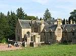
| |||
| No. 1 Braidwood Road, Crossford | 55°41′52″N 3°52′04″W / 55.697683°N 3.867675°W | Category B | 7685 |
| |||
| Lesmahagow Village, Milton Bridge, A74 | 55°38′40″N 3°53′07″W / 55.644518°N 3.885245°W | Category B | 7702 |
|
Key
The scheme for classifying buildings in Scotland is:
- Category A: "buildings of national or international importance, either architectural or historic, or fine little-altered examples of some particular period, style or building type."[1]
- Category B: "buildings of regional or more than local importance, or major examples of some particular period, style or building type which may have been altered."[1]
- Category C(S): "buildings of local importance, lesser examples of any period, style, or building type, as originally constructed or moderately altered; and simple traditional buildings which group well with others in categories A and B."[1]
There are approximately 47,400 listed buildings in Scotland. Of these, around 8 per cent (some 3,800) are Category A, and 51 per cent (24,000) are Category B, with the rest listed at Category C(s).[2]
Notes
- ↑ Sometimes known as OSGB36, the grid reference (where provided) is based on the British national grid reference system used by the Ordnance Survey.
• "Guide to National Grid". Ordnance Survey. Retrieved 2007-12-12.
• "Get-a-map". Ordnance Survey. Retrieved 2007-12-17. - ↑ The "HB Number" is a unique number assigned to each listed building by Historic Scotland.
References
- All entries, addresses and coordinates are based on data from Historic Scotland. This data falls under the Open Government Licence
- 1 2 3 "What is Listing?". Historic Scotland. Retrieved 2010-07-06.
- ↑ Guide to the Protection of Scotland’s Listed Buildings (PDF). Historic Scotland. 2009. p. 17. ISBN 978-1-84917-013-0. Retrieved 2010-07-06.
This article is issued from Wikipedia - version of the 10/15/2016. The text is available under the Creative Commons Attribution/Share Alike but additional terms may apply for the media files.