List of heritage sites in Bellville
This is a list of the heritage sites in Bellville, Western Cape as recognized by the South African Heritage Resources Agency.[1]
| SAHRA identifier | Site name | Description | Town | District | NHRA status | Coordinates | Image |
|---|---|---|---|---|---|---|---|
| 9/2/012/0001 | Vault, Meyboom Avenue, Plattekloof Extension No. 3, Parow | Type of site: Vault | Cape Town, Plattekloof | Bellville | Provincial Heritage Site | 33°51′59″S 18°35′01″E / 33.866450°S 18.583665°E | 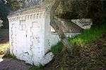 |
| 9/2/012/0002 | 20 Oxford Street, Durbanville | Durbanville | Bellville | 33°49′51″S 18°39′01″E / 33.830878°S 18.650221°E | 
| ||
| 9/2/012/0003 | DURBANVILLE MUNICIPAL AREA, GENERAL | Durbanville | Bellville |
| |||
| 9/2/012/0004 | 46 Oxford Street, Durbanville | Durbanville | Bellville | 33°49′44″S 18°38′44″E / 33.828784°S 18.645601°E | 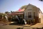 | ||
| 9/2/012/0005 | All Saints Anglican Church, Durbanville | Type of site: Church
|
Durbanville | Bellville | Provincial Heritage Site | 33°50′05″S 18°38′58″E / 33.834687°S 18.649364°E |
|
| 9/2/012/0006 | BELLVILLE MUNICIPAL AREA, GENERAL | Bellville | Bellville |
| |||
| 9/2/012/0007 | Welgemoed Farmstead, Tygerberg Bellville | Bellville | Bellville |  | |||
| 9/2/012/0008 | Berghshoop, Durbanville | Durbanville | Bellville | 33°49′56″S 18°40′13″E / 33.832123°S 18.670327°E |
| ||
| 9/2/012/0009 | PAROW MUNICIPAL AREA, GENERAL | Parow | Bellville |
| |||
| 9/2/012/0010 | King's Court, 4 Church Street, Durbanville | Type of site: House | Durbanville | Bellville | Provincial Heritage Site | 33°49′59″S 18°38′58″E / 33.833143°S 18.649580°E |  |
| 9/2/012/0011 | Nineteenth Century Rubbish Dump, St.Vincent Street, Belhar, Bellville | Bellville | Bellville |
| |||
| 9/2/012/0012 | Milestone XII and Oil lamp, cnr Voortrekker and Durban Roads, Bellville | Type of site: Milestone | Bellville | Bellville | Provincial Heritage Site | 33°54′04″S 18°37′37″E / 33.901242°S 18.626985°E | 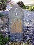 |
| 9/2/012/0013 | Oil lamp, cnr Voortrekker and Durban Roads, Bellville | Type of site: Lamppost | Bellville | Bellville | Provincial Heritage Site | 33°54′05″S 18°37′37″E / 33.901299°S 18.627044°E | 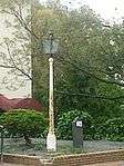 |
| 9/2/012/0014 | Dutch Reformed Church, Weyers Street, Durbanville | The foundation-stone of the Dutch Reformed Church at Durbanville was laid on 1 April 1825 and the church itself was consecrated on 6 August 1826.
The T -shaped church building was enlarged between 1890 and 1891 according to plans by the architect Charles
|
Durbanville | Bellville | Provincial Heritage Site | 33°50′12″S 18°38′48″E / 33.836626°S 18.646650°E |  |
| 9/2/012/0015 | 66 Hopkins Street, Parow | Late Victorian style double storey house.
Hipped gable pitched roof with fibre cement slates.
Double storey bay to left hand side of facade.
Double storey cast iron filigree verandah intact.
Ashlar plasterwork, quoining and plaster surrounds.
Decorative These two impressive double-storey dwelling-houses with their Edwardian and Victorian features were erected in 1910 by George Thomas Hopkins.
The magnificent cast- iron verandah and balcony at 66 Hopkins Street were presumably added by Johannes Petrus Ser
|
Parow | Bellville | Provincial Heritage Site | 33°54′03″S 18°35′12″E / 33.900735°S 18.586679°E | .jpg) |
| 9/2/012/0016 | 64 Hopkins Street, Parow | Late Victorian style double storey house.
Hipped and gabled pitched roof with fibre cement slates.
Double storey bay to left hand side of facade.
Double storey cast iron filigree verandah at entrance of which a portion remains.
Ashlar plasterwork, These two impressive double-storey dwelling-houses with their Edwardian and Victorian features were erected in 1910 by George Thomas Hopkins.
The magnificent cast- iron verandah and balcony at 66 Hopkins Street were presumably added by Johannes Petrus Ser
|
Parow | Bellville | Provincial Heritage Site | 33°54′04″S 18°35′12″E / 33.901000°S 18.586737°E | .jpg) |
| 9/2/012/0017 | Onze Molen, Durbanville | The present mill structure consists of a truncated—cone tower built of coffee stone and plastered with mud.
It has been lime washed.
The structure which originally had a domed shaped cap and sails, was built about 1850.
For many years it served as a wind— This structure, known as Onze Molen, was recorded in 1850 as only the second tower-mill in the Malmesbury district.
It was erected in 1840 and served as a windmill till after the turn of the century when the mechanism and the top portion of the mill were
|
Durbanville | Bellville | Provincial Heritage Site | 33°49′56″S 18°38′21″E / 33.832361°S 18.639187°E |  |
| 9/2/012/0018 | Rust-en-Vrede, Wellington Road, Durbanville | The so-called Rust-en-Vrede building complex, which dates predominantly from the mid nineteenth century, reflects a harmonious blending of Cape Dutch, Georgian and Victorian architectural elements.
Since its erection the complex has served as a prison, a |
Durbanville | Bellville | Provincial Heritage Site | 33°49′55″S 18°38′56″E / 33.831836°S 18.649016°E | 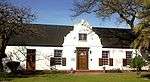 |
| 9/2/012/0019 | Police Station Church Street, Durbanville | Durbanville | Bellville | 33°50′01″S 18°38′57″E / 33.833696°S 18.649073°E | 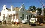 | ||
| 9/2/012/0020-001 | Cape Flats Nature Reserve, University of the Western Cape, Bellville South | Type of site: Nature Reserve This nature reserve of more than 20 hectares provides a haven for rare and typical flora and fauna of the Cape Flats.
The reserve is a unique conservation project, and offers opportunity for research into diseases and the propagation of the Cape flora. |
Cape Town | Bellville | Provincial Heritage Site | 33°56′11″S 18°37′18″E / 33.936389°S 18.621633°E |
|
| 9/2/012/0021 | Evertsdal Homestead, Durban Road, Durbanville | Durbanville | Bellville |
| |||
| 9/2/012/0022 | 12 Queen Street, Durbanville | Durbanville | Bellville | 33°49′55″S 18°38′42″E / 33.831956°S 18.644881°E | 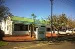 | ||
| 9/2/012/0023 | BELLVILLE MAGISTERIAL DISTRICT, GENERAL | Bellville | Bellville |
| |||
| 9/2/012/0024 | 21 Vrede Street, Durbanville | Durbanville | Bellville | Pending Declaration | 33°54′01″S 18°37′50″E / 33.900203°S 18.630639°E |
| |
| 9/2/012/0025 | Bloemhof, Bloemhof Street, Bellville | Bellville | Bellville | 33°52′53″S 18°38′38″E / 33.881418°S 18.643912°E |
| ||
| 9/2/012/0026 | Altydgedacht Farm, Durbanville | Durbanville | Bellville | 33°50′50″S 18°37′25″E / 33.847195°S 18.623671°E |
| ||
| 9/2/012/0027 | 22 Oxford Street, Durbanville | Durbanville | Bellville | 33°49′52″S 18°38′59″E / 33.830986°S 18.649776°E |
| ||
| 9/2/012/0028 | EDGEMEAD LOCAL AREA, GENERAL | Edgemead | Bellville |
| |||
| 9/2/012/0029 | JOOSTENBERGVLAKTE LOCAL AREA, GENERAL | Joostenbergvlakte | Bellville |
|
References
- ↑ "Western Cape Provincial Heritage Sites (previously National Monuments)" (PDF). 19 September 2002. Retrieved 2013-01-28.
| Wikimedia Commons has media related to Cultural heritage monuments in Bellville, Western Cape. |
Lists of South African Heritage Resources | ||||||||||||||||||||||||||||||||||||
|---|---|---|---|---|---|---|---|---|---|---|---|---|---|---|---|---|---|---|---|---|---|---|---|---|---|---|---|---|---|---|---|---|---|---|---|---|
| SAHRA Heritage sites |
| |||||||||||||||||||||||||||||||||||
| World heritage sites | ||||||||||||||||||||||||||||||||||||