Lawrenceville, West Virginia
| Lawrenceville | |
|---|---|
| Unincorporated community | |
 Lawrenceville  Lawrenceville Location within the state of West Virginia | |
| Coordinates: 40°37′03″N 80°32′37″W / 40.61750°N 80.54361°WCoordinates: 40°37′03″N 80°32′37″W / 40.61750°N 80.54361°W | |
| Country | United States |
| State | West Virginia |
| County | Hancock |
| Time zone | Eastern (EST) (UTC-5) |
| • Summer (DST) | EDT (UTC-4) |
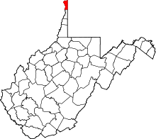
Lawrenceville is an unincorporated community in Hancock County, West Virginia, United States. It is located on the East Liverpool South U.S. Geological Survey Map.[1] It lies at an elevation of 978 feet (289 m).[2]
GNIS ID codes
The GNIS ID codes for Lawrenceville are as follows:
- Lawrenceville: 1554924
- Hancock County: 1560574
- West Virginia: 1779805[3]
Notable Landmarks
References
- ↑ "US > West Virginia > Hancock County > Lawrenceville Lawrenceville (in Hancock County, WV) Populated Place Profile". WVHome Town Locator. Retrieved 26 July 2016.
- ↑ U.S. Geological Survey Geographic Names Information System: Lawrenceville, West Virginia
- ↑ "Lawrenceville, West Virginia". Roadside Thoughts. Retrieved 26 July 2016.
- ↑ http://www.nicholas.duke.edu/thegreengrok/littlebluerun
This article is issued from Wikipedia - version of the 7/28/2016. The text is available under the Creative Commons Attribution/Share Alike but additional terms may apply for the media files.
