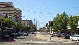
Kingsford, New South Wales
| Kingsford Sydney, New South Wales | |||||||||||||
|---|---|---|---|---|---|---|---|---|---|---|---|---|---|
|
Souths Juniors, Anzac Parade | |||||||||||||
| Population | 14,101 (2011 census)[1] | ||||||||||||
| Postcode(s) | 2032 | ||||||||||||
| Location | 7 km (4 mi) south-east of Sydney CBD | ||||||||||||
| LGA(s) | City of Randwick | ||||||||||||
| State electorate(s) | |||||||||||||
| Federal Division(s) | Kingsford Smith | ||||||||||||
| |||||||||||||

Charles_Kingsford_Smith_Tribute-1.jpg)
Kingsford is a suburb in the Eastern Suburbs of Sydney, in the state of New South Wales, Australia. Kingsford is located 7 kilometres south-east of the Sydney central business district, in the local government area of the City of Randwick. Kingsford is part of the Eastern Suburbs region.
Location
Kingsford is a mainly residential area, situated directly south of the University of New South Wales, which is in Kensington. Many of the residents are students living in medium and high density housing. A large Australian Army depot lies in the east of Kingsford.
At the centre of Kingsford, on Anzac Parade and Gardeners Road, there is a large roundabout connecting a public transport system to nine possible destinations via a large number of bus services. For this reason, this part of Kingsford is sometimes referred to as "nine-ways". Kingsford is less than 5 km from Coogee Beach.
History
The area was once known as South Kensington. It was named Kingsford to honour Australian aviator Sir Charles Kingsford Smith (1897–1935), as was the nearby Sydney Airport. Kingsford was undeveloped until a land boom in the 1920s. In the 1940s, many Greeks settled in the area, particularly migrants from the island of Castellorizo (or Kastellorizo). Many opened businesses in the area; and, in 1973, they built the Castellorizian Club on Anzac Parade. Kingsford was originally intended to be the terminus of the Eastern Suburbs railway line; but, as a cost-cutting measure, the line was terminated at Bondi Junction in 1979.[2]
Charles Kingsford Smith Tribute
In 2010, a tribute was created to Charles Kingsford Smith in Gardeners Lane, off Anzac Parade. The tribute consisted of a mosaic of Smith, a mosaic of his plane, the Southern Cross, and a Trans Pacific Mural depicting the Southern Cross. The tribute was unveiled on 11 August 2010 by Mayor John Procopiadis. It was designed by Masoud Nodous; the artist was Tim Cole. In 2014, the mural depicting the Southern Cross was added. The artist was Annette Barlow.
Population
At the 2011 census, the largest number of overseas-born residents came from China, Indonesia, Malaysia, Greece, and England. The highest reported ancestries are Chinese (22%), Australian (13%), English (12.4%), Greek (8.2%), and Irish (5.5%).[3]
Politics
At the federal government level of politics, Kingsford is part of the Division of Kingsford Smith in the Australian House of Representatives. Kingsford Smith has always been a Labor (ALP) stronghold.
Churches and schools
- St Spyridon is a Greek Orthodox Church on Gardeners Road.[4] St Spyridon College is a private school, adjacent to the church.
- The Indonesian Presbyterian Church and Kingsway Church are located at 94 Houston Road.[5]
- Holy Trinity Anglican Church, Sturt Street, Kingsford
- Gereja Focus Indonesia is an Indonesian students' church located on UNSW campus[6]
- Kingsford Church of Christ is located on Anzac Parade[7]
Holy_Trinity_Church_Kingsford_Sydney.jpg) Holy Trinity Anglican Church, Sturt Street
Holy Trinity Anglican Church, Sturt Street St Spyridon's Greek Orthodox Church, Gardeners Road
 Indonesian Presbyterian Church, Houston Road
 Church of Christ, Anzac Parade
References
- ↑ Australian Bureau of Statistics (31 October 2012). "Kingsford (State Suburb)". 2011 Census QuickStats. Retrieved 24 October 2013.
- ↑ The Book of Sydney Suburbs, Compiled by Frances Pollen, Angus & Robertson Publishers, 1990, Published in Australia ISBN 0-207-14495-8, page 138
- ↑ 2011 Census QuickStats: 2032 NSW
- ↑ St Spyridon – Australia
- ↑ Kingsway Church
- ↑ Gereja Focus Indonesia
- ↑ Church of Christ, Kingsford
| Wikimedia Commons has media related to Kingsford, New South Wales. |
Coordinates: 33°55′28″S 151°13′40″E / 33.92457°S 151.22765°E