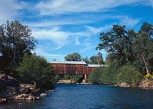
Honey Run Covered Bridge
|
Honey Run Covered Bridge | |
|
A picture from the Historic American Engineering Record | |
  | |
| Location | Butte County, California |
|---|---|
| Nearest city | Chico, California |
| Coordinates | 39°43′43″N 121°42′13″W / 39.72861°N 121.70361°WCoordinates: 39°43′43″N 121°42′13″W / 39.72861°N 121.70361°W |
| Built | 1894 |
| Architect | Martindale, S. A. |
| Architectural style | Other |
| NRHP Reference # | 88000920 |
| Added to NRHP | June 23, 1988[1] |
Honey Run Covered Bridge is a wooden covered bridge crossing Butte Creek, in Butte County, northern California.
It is located on Honey Run Road at Centerville Road, about halfway in between Chico and Paradise.
History
The wooden Honey Run Bridge was originally built in 1886, and was later covered in 1894.
The bridge was open to vehicular traffic until a car crashed into and damaged it in 1965. An new steel bridge was built upstream for vehicular traffic.
The covered bridge is now used as a pedestrian footbridge, protected within Honey Run Covered Bridge County Park. It was rebuilt from the ruins and opened in 1972.[2]
It was listed on the National Register of Historic Places in 1988.[1]
See also
References
- 1 2 National Park Service (2008-04-15). "National Register Information System". National Register of Historic Places. National Park Service.
- ↑ Miller, Terry E. America's Covered Bridges. Tuttle.
External links
- Honey Run Covered Bridge
- Historic American Engineering Record (HAER) No. CA-312, "Honey Run Bridge, Spanning Butte Creek, bypassed section of Honey Run Road (originally Carr Hill Road), Paradise vicinity, Butte County, CA", 18 photos, 2 color transparencies, 9 measured drawings, 16 data pages, 2 photo caption pages
| Wikimedia Commons has media related to Honey Run Covered Bridge. |
This article is issued from Wikipedia - version of the 11/25/2016. The text is available under the Creative Commons Attribution/Share Alike but additional terms may apply for the media files.


