National Register of Historic Places listings in Del Norte County, California

Location of Del Norte County in California
This is a list of the National Register of Historic Places listings in Del Norte County, California.
This is intended to be a complete list of the properties and districts on the National Register of Historic Places in Del Norte County, California, United States. Latitude and longitude coordinates are provided for many National Register properties and districts; these locations may be seen together in a Google map.[1]
There are 14 properties and districts listed on the National Register in the county.
- This National Park Service list is complete through NPS recent listings posted December 16, 2016.[2]
Current listings
| [3] | Name on the Register[4] | Image | Date listed[5] | Location | City or town | Description |
|---|---|---|---|---|---|---|
| 1 | BROTHER JONATHAN (Shipwreck Site) | 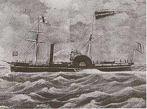 |
(#02000535) |
About 4.5 miles (7.2 km) west of Point St. George 41°46′29″N 124°20′50″W / 41.774722°N 124.347222°W |
Crescent City | |
| 2 | Crescent City Lighthouse | 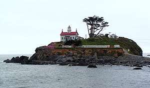 |
(#83001177) |
A St., Battery Point Island 41°44′39″N 124°12′07″W / 41.744167°N 124.201944°W |
Crescent City | Also known as Battery Point Light |
| 3 | Endert's Beach Archeological Sites |  |
(#77000121) |
Address Restricted |
Crescent City | |
| 4 | Gasquet Ranger Station Historic District | 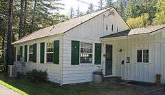 |
(#98000262) |
10600 CA 199 41°50′43″N 123°57′51″W / 41.845278°N 123.964167°W |
Gasquet | |
| 5 | Mus-yeh-sait-neh Village and Cultural Landscape Property | Upload image | (#93001109) |
Address Restricted |
Gasquet | |
| 6 | O'Men Village Site | Upload image | (#77000120) |
Address Restricted |
Klamath | |
| 7 | Old Requa | Upload image | (#74000509) |
Address Restricted |
Redwood National Park | |
| 8 | Osgood Ditch | Upload image | (#01001151) |
Historic channel of Osgood Ditch 41°57′59″N 123°37′56″W / 41.966389°N 123.632222°W |
Siskiyou National Forest | Extends into Josephine County, Oregon |
| 9 | Point St. George Site | Upload image | (#76000481) |
Address Restricted |
Crescent City | |
| 10 | Radar Station B-71 | .jpg) |
(#78000282) |
W of Klamath 41°31′20″N 124°04′45″W / 41.522222°N 124.079167°W |
Klamath | |
| 11 | Redwood Highway | .jpg) |
(#79000253) |
W of Klamath 41°36′36″N 124°06′26″W / 41.61°N 124.107222°W |
Klamath | The segment of present-day U.S. Route 101 through Redwood National and State Parks |
| 12 | St. George Reef Light Station | 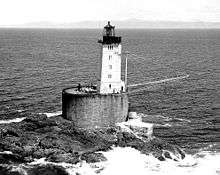 |
(#93001373) |
NW Seal Rock, approximately 6 nautical mi. off coast from Point St. George 41°50′14″N 124°22′31″W / 41.837222°N 124.375278°W |
Crescent City | |
| 13 | Upper Ditch | Upload image | (#01001149) |
Historic channel of Logan/Esterly Upper Ditch 42°01′10″N 123°38′06″W / 42.019444°N 123.635°W |
Siskiyou National Forest | Extends into Josephine County, Oregon. This ditch, built in 1854 to supply water from the East Fork Illinois River to several hydraulic mines, quickly returned a large profit to its investors. The ditch supplied mines worked by its own owners, as well as providing water for sale to other nearby diggings. It continued in operation until 1942, when the last hydraulic mining operations in the upper Illinois Valley ceased.[6] |
| 14 | Yontocket Historic District | Upload image | (#73000400) |
Address Restricted |
Fort Dick |
See also
| Wikimedia Commons has media related to National Register of Historic Places in Del Norte County, California. |
- List of National Historic Landmarks in California
- National Register of Historic Places listings in California
- California Historical Landmarks in Del Norte County, California
References
- ↑ The latitude and longitude information provided in this table was derived originally from the National Register Information System, which has been found to be fairly accurate for about 99% of listings. For about 1% of NRIS original coordinates, experience has shown that one or both coordinates are typos or otherwise extremely far off; some corrections may have been made. A more subtle problem causes many locations to be off by up to 150 yards, depending on location in the country: most NRIS coordinates were derived from tracing out latitude and longitudes off of USGS topographical quadrant maps created under the North American Datum of 1927, which differs from the current, highly accurate WGS84 GPS system used by most on-line maps. Chicago is about right, but NRIS longitudes in Washington are higher by about 4.5 seconds, and are lower by about 2.0 seconds in Maine. Latitudes differ by about 1.0 second in Florida. Some locations in this table may have been corrected to current GPS standards.
- ↑ "National Register of Historic Places: Weekly List Actions". National Park Service, United States Department of the Interior. Retrieved on December 16, 2016.
- ↑ Numbers represent an ordering by significant words. Various colorings, defined here, differentiate National Historic Landmarks and historic districts from other NRHP buildings, structures, sites or objects.
- ↑ National Park Service (2010-07-09). "National Register Information System". National Register of Historic Places. National Park Service.
- ↑ The eight-digit number below each date is the number assigned to each location in the National Register Information System database, which can be viewed by clicking the number.
- ↑ Atwood, Katherine C.; Tonsfeldt, Ward (August 17, 2000), National Register of Historic Places Registration Form: Upper Ditch (PDF), retrieved April 21, 2014.
| Topics | |
|---|---|
| Lists by states |
|
| Lists by insular areas | |
| Lists by associated states | |
| Other areas | |
| |
Municipalities and communities of Del Norte County, California, United States | ||
|---|---|---|
| City | | |
| CDPs | ||
| Unincorporated communities | ||
| Indian reservations | ||
| Ghost towns |
| |
This article is issued from Wikipedia - version of the 10/2/2016. The text is available under the Creative Commons Attribution/Share Alike but additional terms may apply for the media files.