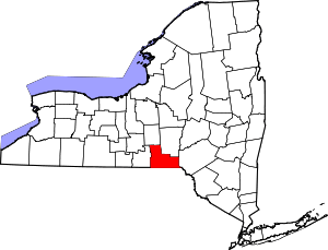
Hillcrest, Broome County, New York
| Hillcrest, New York | |
|---|---|
| Residential | |
| Nickname(s): "The Crest" | |
| Country | United States |
| State | New York |
| County | Broome |
| Population (2000) | |
| • Total | 2,680 |
Hillcrest is a residential community outside of Binghamton, New York. Neighboring Chenango Bridge and the village of Port Dickinson, this suburb is an unincorporated entity within the Town of Fenton. Hillcrest contains numerous single-family homes, a high school, two public parks, three churches, a public library, a cemetery, numerous industries and businesses, and a central plaza area within walking distance of most homes that includes a gas station, family-run Italian restaurant, ice cream parlor, diner, and Subway (restaurant). It lies in Broome County, and borders I-88 and the Chenango River.
Places of interest
Some places of interest for community members and visitors are:
- Chenango Valley High School- a local high school.
- Hillcrest Little League Field - site of a little league and softball field.
- Bella Pizza - Family-owned pizza and Italian restaurant in the Hillcrest Heights Plaza, established 1983.
- Suzy Q's - Family-owned ice cream parlor in the Hillcrest Heights Plaza offering ice cream cones, shakes, and sundaes.
- Sunoco - Gas station and convenience store in the Hillcrest Heights Plaza.
- Fraternity - Family-owned Chinese take-out restaurant in the Hillcrest Heights Plaza.
- Laura's Luncheonette - Breakfast and lunch diner.
- Hillcrest Subway
- Fenton Free Library - Community run library.
- Chenango Valley Cemetery
- NorthPointe Church - A Non-denominational church with modern worship emphasis, located on the East Service Road.[1]
- St. Francis of Assisi - Catholic Church, former school, and gymnasium.
- Ogden Hillcrest UMC - United Methodist Church, and Thrift Shop
- Adaptive Driving School
- Stone Spillway, National Defense Stockpile Center - listed on the National Register of Historic Places in 2004.[2]
- The birthplace of Mother Crest - Chase Court
References
- ↑ http://www.northpointeny.org/
- ↑ National Park Service (2009-03-13). "National Register Information System". National Register of Historic Places. National Park Service.
Coordinates: 42°09′13″N 75°53′03″W / 42.153667°N 75.884261°W
This article is issued from Wikipedia - version of the 9/2/2016. The text is available under the Creative Commons Attribution/Share Alike but additional terms may apply for the media files.
