Garça de Cima
| Garça de Cima | |
|---|---|
|
The Garça Valley and the village | |
 | |
| Coordinates: 17°06′50″N 25°09′54″W / 17.114°N 25.165°WCoordinates: 17°06′50″N 25°09′54″W / 17.114°N 25.165°W | |
| Country | Cape Verde |
| Island | Santo Antão |
| Municipality | Ribeira Grande |
| Civil parish | São Pedro Apóstolo |
| Population (2010)[1] | |
| • Total | 1,138 |
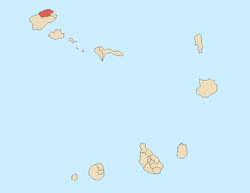
Garça de Cima is a settlement in the northern part of the island of Santo Antão, Cape Verde. It is situated in the upper valley of the river Ribeira da Garça, 15 km northwest of the island capital Porto Novo and 40 kilometrers by road. The southernmost part are included in Moroços Natural Park.
In the northernmost portion at Canto de Cagarra is the island's own dam, it was finished on November 16, 2014,[2] the only large dam on the island located roughly in the middle of the stream. The reservoir is predominantly dry and are being the two in Cape Verde, the other is Salineiro on the Ribeira Grande de Santiago north of Cidade Velha on Santiago Island.
See also
References
- ↑ "2010 Census results". Instituto Nacional de Estatística Cabo Verde (in Portuguese). 17 March 2014.
- ↑ "Santo Antão: Barragem de Canto de Cagarra foi inaugurada hoje" [Canto de Cagarra Dam to be Completed Today]. Inforpress (in Portuguese). 15 November 2014. Retrieved 16 November 2014.
This article is issued from Wikipedia - version of the 12/1/2016. The text is available under the Creative Commons Attribution/Share Alike but additional terms may apply for the media files.

