Góra Ziuty
| Góra Ziuty | |
|---|---|
| Buchberg | |
|
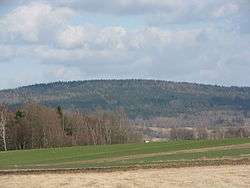
Góra Ziuty seen from Lipienica | |
| Highest point | |
| Elevation | 631 m (2,070 ft) |
| Coordinates | 50°43′49″N 16°06′46″E / 50.73028°N 16.11278°ECoordinates: 50°43′49″N 16°06′46″E / 50.73028°N 16.11278°E |
| Geography | |
 Góra Ziuty | |
| Parent range | Krzeszowskie Wzgórza |
Góra Ziuty [ɡura ˈʑutɨ] (ger. Buchberg, 631 m a.s.l.) - the highest peak bandwidth Krzeszowskie Wzgórza, within Kotlina Kamiennogórska in Central Sudetes.
Position
The peak is located in the northern part of the Krzeszowskie Wzgórza. In the north east, through the Przełęcz Grzędzka borders with the band the Czarny Las in the Stone Mountains, the west connects with the Góra Świętej Anny, in the south of Post Berg.
Bibliography
- Słownik geografii turystycznej Sudetów, tom 8 Kotlina Kamiennogórska, Wzgórza Bramy Lubawskiej, Zawory, red. Marek Staffa, Wydawnictwo I-BiS, Wrocław 1997, ISBN 83-85773-23-1, s. 171 i 172
- Sudety Środkowe. Skala 1:40000. Jelenia Góra: Wydawnictwo Turystyczne Plan, 2005. ISBN 83-60044-44-9
This article is issued from Wikipedia - version of the 5/9/2016. The text is available under the Creative Commons Attribution/Share Alike but additional terms may apply for the media files.