Góra Świętej Anny (Krzeszowskie Wzgórza)
| Góra Świętej Anny | |
|---|---|
| Annaberg | |
|
Góra Świętej Anny seen from Krzeszów | |
| Highest point | |
| Elevation | 593 m (1,946 ft) |
| Coordinates | 50°44′02″N 16°05′33″E / 50.73389°N 16.09250°ECoordinates: 50°44′02″N 16°05′33″E / 50.73389°N 16.09250°E |
| Geography | |
 Góra Świętej Anny | |
| Parent range | Krzeszowskie Wzgórza |
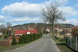
Góra Świętej Anny [ˈɡura ɕviɛ̃tɛj annɨ] (ger. Annen Berg, Annaberg) – peak 593 m a.s.l. in north-west part of band Krzeszowskie Wzgórza, in precinct Kotlina Kamiennogórska, in Central Sudetes.
The geological structure
The summit is made up of Upper Cretaceous sandstones glauconite and mudstones. Below them, on the north side, arrears sandstones and conglomerates of rotliegend.
Vegetation
The apex as well as the majority of bands covered with pine forest, the undersigned, west stretch meadows.
Chapel of Saint Anne
Below the summit, on the western side of the Baroque chapel of St. Anna 1623. Destroyed in the second half of the twentieth century, the efforts of the inhabitants of Krzeszów was in the second decade of the twenty-first century rebuilt.[1] Less than 3 chapels residues pilgrimage route from Krzeszów.
Bibliography
- Marek Staffa: Słownik geografii turystycznej Sudetów, tom 8, Kotlina Kamiennogórska, Wzgórza Bramy Lubawskiej, Zawory. Wrocław: Wydawnictwo I-BiS, 1997. ISBN 83-85773-23-1., s. 106 i 107
- Sudety Środkowe. Skala 1:40000. Jelenia Góra: Wydawnictwo Turystyczne Plan, 2005. ISBN 83-60044-44-9.
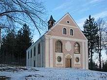 Chapel of Saint Anne
Cites
- ↑ "Odbudowali w czynie społecznym kościół - Nasze Sudety". www.naszesudety.pl. Retrieved 2016-04-23.