Dorrigo National Park
| Dorrigo National Park New South Wales | |
|---|---|
|
IUCN category II (national park) | |
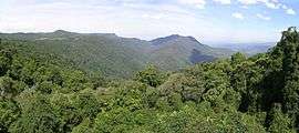
 View from the Skywalk, Dorrigo National Park | |
 Dorrigo National Park | |
| Nearest town or city | Dorrigo |
| Coordinates | 30°20′53″S 152°49′19″E / 30.34806°S 152.82194°ECoordinates: 30°20′53″S 152°49′19″E / 30.34806°S 152.82194°E |
| Established | 1 October 1967 |
| Area | 119 km2 (45.9 sq mi) |
| Managing authorities | National Parks and Wildlife Service (New South Wales) |
| Website | Dorrigo National Park |
| See also |
Protected areas of New South Wales |
Dorrigo National Park is a national park in New South Wales (Australia), 580 km north of Sydney on Dome Road off the Waterfall Way, 5 km east of the town of Dorrigo.
The Park is part of the New England Group of the World Heritage Site Gondwana Rainforests of Australia inscribed in 1986 and added to the Australian National Heritage List in 2007.
This national park is recognised as an area of exceptional natural beauty with significant habitats of outstanding value to science and conservation.
The Rainforest Centre is a major CERRA interpretation centre. The interactive display, The Rainforest Revealed, explains how the rainforest evolved and gives insights into the animal and plant species that live there.
The park contains several tracks allowing hikers to view the park's waterfalls and vistas to the coastal plain. A notable feature of the park is the Skywalk, an elevated walkway through and above the treetops, providing birdwatchers with an excellent view of local bird life.
Gallery
 Red Cedar Falls on the Rosewood Creek Track
.jpg) Wonga Walk rainforest
Wonga Walk rainforest- Crystal Falls on Wonga Walk
- Mushrooms on Wonga Walk
 Tristania Falls on Wonga Walk
See also
External links
| Wikimedia Commons has media related to Dorrigo National Park. |