Districts of Laos
 |
| This article is part of a series on the politics and government of Laos |
|
Ideology |
| Constitution |
|
|
Legislature
|
|
|
Mass organizations
|
|
|
Laos is divided into 16 provinces (Lao ແຂວງ, khoueng) and 1 prefecture (kampheng nakhon) plus capital city municipality (ນະຄອນຫລວງ, nakhon luang). Furthermore, 1 so-called special administrative zone (ເຂດພິເສດ, khet phiset) existed between 1994 and 2006, when it was re-merged into its surrounding provinces (i.e. Vientiane and Xiangkhoang). Each province is subdivided into districts (muang) and then subdivided into villages (baan).
Districts of Laos
- Note — Each district has a code in parentheses displaying the first two digits as the province and the last two as the district representing that province.
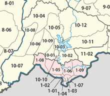
Vientiane Capital District Map

Phongsaly Province District Map

Louang Namtha Province District Map

Oudomxay Province District Map

Bokeo Province District Map

Luang Prabang Province District Map

Houaphan Province District Map

Sainyabuli Province District Map

Xiengkhuang Province District Map

Vientiane Province District Map

Bolikhamsai Province District Map

Khammouane Province District Map

Savannakhet Province District Map

Salavan Province District Map

Sekong Province District Map

Champasak Province District Map

Attapeu Province District Map
._Laos.svg.png)
New map of the Xaisomboun Province since 2014[1]
References
- ↑ "Old and new geographical delimitations and administrative districts of the new Xaisomboun province after 2014". Official Laos Government Presentation. Retrieved 13 December 2013.
External links
- "Provinces of Laos". Statoids.
- "Districts of Laos". Statoids.
- Laos Ministry of Education district maps
This article is issued from Wikipedia - version of the 5/20/2016. The text is available under the Creative Commons Attribution/Share Alike but additional terms may apply for the media files.