Daigo, Ibaraki
| Daigo 大子町 | |||
|---|---|---|---|
| Town | |||
|
Daigo town office | |||
| |||
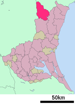
 Location of Daigo in Ibaraki Prefecture | |||
 Daigo
| |||
| Coordinates: 36°46′5.2″N 140°21′18.8″E / 36.768111°N 140.355222°ECoordinates: 36°46′5.2″N 140°21′18.8″E / 36.768111°N 140.355222°E | |||
| Country | Japan | ||
| Region | Kantō | ||
| Prefecture | Ibaraki Prefecture | ||
| District | Kuji | ||
| Area | |||
| • Total | 325.76 km2 (125.78 sq mi) | ||
| Population (September 2015) | |||
| • Total | 17,980 | ||
| • Density | 55.2/km2 (143/sq mi) | ||
| Time zone | Japan Standard Time (UTC+9) | ||
| - Tree | Fagus crenata | ||
| - Flower | Tea | ||
| - Bird | Aix galericulata | ||
| Phone number | 0295-72-1111 | ||
| Address | 866 Daigo, Daigo-machi, Kuji-gun, Ibaraki-ken 319-3526 | ||
| Website | Official website | ||
Daigo (大子町 Daigo-machi) is a town located in Kuji District, Ibaraki Prefecture, in the northern Kantō region of Japan. As of September 2015, the town had an estimated population of 17,980 and a population density of 55.2 persons per km². Its total area was 325.76 km².
Geography
Located in northwestern Ibaraki Prefecture, Daigo is bordered to the north by Fukushima Prefecture and to the west by Tochigi Prefecture. There are many onsen located in Daigo.
Surrounding municipalities
History
Daigo village was created with the establishment of the municipalities system on April 1, 1889. It was elevated to town status on July 20, 1891. On March 31, 1955, the villages of Yorigami, Fururoda, Miyagawa, Kurosawa, Namase, Kamiogawa, Shimoogawa and Murotono merged with Daigo.
Education
- Daigo has seven elementary schools, four middle schools and two high schools, along with one special education school.
Transportation
Railway
Highway
Local attractions
- Fukuroda Falls – one of Japan's Top 100 Waterfalls
- Daigo onsen
- Fukuroda onsen
Noted people
- Yasunori Kikuchi – professional baseball player
- Yasumitsu Toyoda – professional baseball player
External links
![]() Media related to Daigo, Ibaraki at Wikimedia Commons
Media related to Daigo, Ibaraki at Wikimedia Commons
- Official website (Japanese)


