Cuchara, Colorado
Entering Cuchara from the north on State Highway 12.
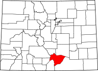
Cuchara is an unincorporated community in Huerfano County, Colorado, United States. It is located near a former ski resort in the mountains south of the town of La Veta.[1] Its altitude is 8,468 feet (2,581 m).[2] State Highway 12 travels through Cuchara as it approaches Trinidad to the southeast.
Cuchara is situated on the eastern slopes of the Sangre de Cristo Mountains in south-central Colorado. It is west of the Spanish Peaks. Cucharas Pass, at almost 10,000 feet, is a few miles south of the town of Cuchara. The Cucharas River flows on the outskirts of town. The San Isabel National Forest surrounds the town.[1]
References
- 1 2 "Cuchara, Colorado" Sangres.com. Retrieved 23 July 2009.
- ↑ U.S. Geological Survey Geographic Names Information System: Cuchara, Colorado
Coordinates: 37°22′45″N 105°06′01″W / 37.37917°N 105.10028°W
This article is issued from Wikipedia - version of the 8/7/2016. The text is available under the Creative Commons Attribution/Share Alike but additional terms may apply for the media files.
