Colinet, Newfoundland and Labrador
| Colinet | |
|---|---|
| Town | |
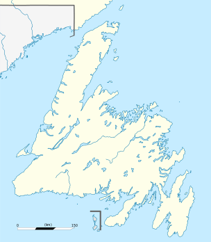
 Colinet Location of Colinet in Newfoundland | |
| Coordinates: 47°13′N 53°34′W / 47.217°N 53.567°W | |
| Country |
|
| Province |
|
| Area | |
| • Total | 6.23 km2 (2.41 sq mi) |
| Elevation | 12 m (39 ft) |
| Population (2011) | |
| • Total | 110[1] |
| Time zone | Newfoundland Time (UTC-3:30) |
| • Summer (DST) | Newfoundland Daylight (UTC-2:30) |
| Area code(s) | 709 |
Colinet is an incorporated town located on the northwest arm of St. Mary's Bay in Newfoundland and Labrador, Canada.
Geography
Colinet is notable for two rivers, the Rocky and the Colinet, which enter the sea in or near the town.
The Rocky River has a man-made salmon ladder spanning the 8 metres (26 ft) waterfalls at its mouth. Originally not a salmon river because of those falls, the river was seeded with salmon fry in the mid-1980s. The salmon began using the man-made ladder to bypass the falls in 1987. In 2002, the river opened to recreational anglers, making it Atlantic Canada's newest salmon river.
Climate
| Climate data for Colinet | |||||||||||||
|---|---|---|---|---|---|---|---|---|---|---|---|---|---|
| Month | Jan | Feb | Mar | Apr | May | Jun | Jul | Aug | Sep | Oct | Nov | Dec | Year |
| Record high °C (°F) | 15 (59) |
15.6 (60.1) |
16.7 (62.1) |
21 (70) |
23 (73) |
27.8 (82) |
29.4 (84.9) |
28.9 (84) |
28 (82) |
23.5 (74.3) |
18 (64) |
16.7 (62.1) |
29.4 (84.9) |
| Average high °C (°F) | 0.2 (32.4) |
−0.2 (31.6) |
2.2 (36) |
6.2 (43.2) |
10.5 (50.9) |
14.2 (57.6) |
18.3 (64.9) |
19.1 (66.4) |
16.1 (61) |
11.4 (52.5) |
7.1 (44.8) |
2.5 (36.5) |
9 (48) |
| Average low °C (°F) | −7.9 (17.8) |
−8.7 (16.3) |
−5.4 (22.3) |
−1.2 (29.8) |
1.9 (35.4) |
5.9 (42.6) |
10.3 (50.5) |
11.3 (52.3) |
7.6 (45.7) |
3.6 (38.5) |
0.1 (32.2) |
−4.8 (23.4) |
1.1 (34) |
| Record low °C (°F) | −25.6 (−14.1) |
−28.9 (−20) |
−26 (−15) |
−13.9 (7) |
−7.8 (18) |
−4.4 (24.1) |
−1.1 (30) |
−1.1 (30) |
−5 (23) |
−10 (14) |
−14.4 (6.1) |
−24.4 (−11.9) |
−28.9 (−20) |
| Average precipitation mm (inches) | 130.4 (5.134) |
113.2 (4.457) |
105 (4.13) |
92.5 (3.642) |
96.9 (3.815) |
118.7 (4.673) |
102.4 (4.031) |
128.4 (5.055) |
119.4 (4.701) |
136.3 (5.366) |
126.4 (4.976) |
121.5 (4.783) |
1,391 (54.76) |
| Source: 1961-1990 Environment Canada [2] | |||||||||||||
Demographics
As of 2011 the town of Colinet had a population of 110 a -33.3% change from 2006 when the population was 165.[1]
Coordinates: 47°13′N 53°34′W / 47.217°N 53.567°W
See also
References
- 1 2 "Colinet Census". Statistics Canada. Retrieved 8 October 2012.
- ↑ Environment Canada—Canadian Climate Normals 1961–1990. Retrieved 7 October 2012.
External links
- 2006 Census Community Profile for Colinet
- The Making of a Salmon River: Rocky River, St. Mary's Bay
- the Rocky River Fishway
