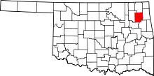
Chouteau, Oklahoma
| Chouteau, Oklahoma | |
|---|---|
| Town | |
|
Location of Chouteau, Oklahoma | |
| Coordinates: 36°11′13″N 95°20′18″W / 36.18694°N 95.33833°WCoordinates: 36°11′13″N 95°20′18″W / 36.18694°N 95.33833°W | |
| Country | United States |
| State | Oklahoma |
| County | Mayes |
| Area | |
| • Total | 2.4 sq mi (6.2 km2) |
| • Land | 2.4 sq mi (6.2 km2) |
| • Water | 0.0 sq mi (0.0 km2) |
| Elevation | 627 ft (191 m) |
| Population (2010) | |
| • Total | 2,097 |
| • Density | 808.1/sq mi (312.0/km2) |
| Time zone | Central (CST) (UTC-6) |
| • Summer (DST) | CDT (UTC-5) |
| ZIP code | 74337 |
| Area code(s) | 539/918 |
| FIPS code | 40-14300[1] |
| GNIS feature ID | 1091332[2] |
Chouteau /ʃoʊˈtoʊ/ is the second-largest town in Mayes County, Oklahoma, United States. The population was 2,097 at the 2010 census,[3] an increase of 8.6 percent from 1,931 at the 2000 census.[4]
Geography
Chouteau is located at 36°11′13″N 95°20′18″W / 36.186957°N 95.338272°W.[5]
According to the United States Census Bureau, the town has a total area of 2.4 square miles (6.2 km2), all of it land.
The town is situated near the junction of U.S. Routes 69 and 412.
History
Chouteau, originally called Cody's Creek, became a stop on the Katy railroad in 1871. It soon became a thriving cattle town.[6] The name was changed to Chouteau after the creek that flows north of town that was named for French fur trader Auguste Pierre Chouteau from the Chouteau family. Auguste created the first permanent white settlement in present-day Salina, Oklahoma.
Demographics
| Historical population | |||
|---|---|---|---|
| Census | Pop. | %± | |
| 1910 | 483 | — | |
| 1920 | 541 | 12.0% | |
| 1930 | 430 | −20.5% | |
| 1940 | 400 | −7.0% | |
| 1950 | 658 | 64.5% | |
| 1960 | 958 | 45.6% | |
| 1970 | 1,046 | 9.2% | |
| 1980 | 1,559 | 49.0% | |
| 1990 | 1,771 | 13.6% | |
| 2000 | 1,931 | 9.0% | |
| 2010 | 2,097 | 8.6% | |
| Est. 2015 | 2,092 | [7] | −0.2% |
As of the 2010 census Chouteau had a population of 2,097. The racial and ethnic composition of the population was 74.9% white, 0.2% black or African American, 16.3% Native American, 0.2% Asian, 0.1% Pacific Islander, 0.2% some other race and 8.1% from two or more races. 1.8% of the population was Hispanic or Latino of any race.[9]
As of the census[1] of 2000, there were 1,931 people, 751 households, and 560 families residing in the town. The population density was 808.1 people per square mile (312.0/km2). There were 806 housing units at an average density of 337.3 per square mile (130.2/km2). The racial makeup of the town was 77.01% White, 0.41% African American, 14.34% Native American, 0.21% Asian, 1.19% from other races, and 6.84% from two or more races. Hispanic or Latino of any race were 1.76% of the population.
There were 751 households out of which 35.3% had children under the age of 18 living with them, 58.2% were married couples living together, 12.1% had a female householder with no husband present, and 25.4% were non-families. 22.9% of all households were made up of individuals and 10.3% had someone living alone who was 65 years of age or older. The average household size was 2.52 and the average family size was 2.95.
In the town the population was spread out with 26.6% under the age of 18, 8.3% from 18 to 24, 27.1% from 25 to 44, 22.4% from 45 to 64, and 15.7% who were 65 years of age or older. The median age was 37 years. For every 100 females there were 91.8 males. For every 100 females age 18 and over, there were 91.6 males.
The median income for a household in the town was $32,950, and the median income for a family was $40,109. Males had a median income of $31,750 versus $19,559 for females. The per capita income for the town was $15,482. About 12.2% of families and 14.8% of the population were below the poverty line, including 19.9% of those under age 18 and 11.7% of those age 65 or over. The major employer for Chouteau and the surrounding area is the MidAmerica Industrial Park, located approximately three miles northeast of town.
Notable people
- Johnny Ray (born 1957)- Major League Baseball player for the Pittsburgh Pirates and California Angels
Richard Couch, PhD. BS (Oklahoma State Universary, 1959); MS (University of Tennessee, 1961); PhD (Auburn University.1965). Professor of Biology, Oral Roberts University (36 years); 9 years at Athens College, Alabama and University of Tennessee.
References
- 1 2 "American FactFinder". United States Census Bureau. Archived from the original on 2013-09-11. Retrieved 2008-01-31.
- ↑ "US Board on Geographic Names". United States Geological Survey. 2007-10-25. Retrieved 2008-01-31.
- ↑ Pryor Daily Times. "Mayes County grows by 3,000. April 4, 2011. Retrieved September 14, 2011.
- ↑ CensusViewer:Population of the City of Chouteau, Oklahoma
- ↑ "US Gazetteer files: 2010, 2000, and 1990". United States Census Bureau. 2011-02-12. Retrieved 2011-04-23.
- ↑ Encyclopedia of Oklahoma History and Culture. Hastings, Virginia Lindsey.
- ↑ "Annual Estimates of the Resident Population for Incorporated Places: April 1, 2010 to July 1, 2015". Retrieved July 2, 2016.
- ↑ "Census of Population and Housing". Census.gov. Archived from the original on May 11, 2015. Retrieved June 4, 2015.
- ↑ 2010 general profile of population and housing characteristics for Chouteau, Oklahoma from the US Census
