Bunk Foss, Washington
| Bunk Foss, Washington | |
|---|---|
| CDP | |
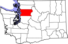
 Bunk Foss, Washington Location of Bunk Foss, Washington. | |
| Coordinates: 47°57′42″N 122°5′40″W / 47.96167°N 122.09444°WCoordinates: 47°57′42″N 122°5′40″W / 47.96167°N 122.09444°W | |
| Country | United States |
| State | Washington |
| County | Snohomish |
| Area | |
| • Total | 3.874 sq mi (10.03 km2) |
| • Land | 3.874 sq mi (10.03 km2) |
| • Water | 0.000 sq mi (0.0 km2) |
| Population (2010) | |
| • Total | 3,570 |
| • Density | 921.5/sq mi (355.8/km2) |
| Time zone | Pacific (PST) (UTC-8) |
| • Summer (DST) | PDT (UTC-7) |
| GNIS feature ID | 2584953[1] |
Bunk Foss is a census-designated place (CDP) in Snohomish County, Washington, United States. The population was 3,570 at the 2010 census. Bunk Foss was created out of the former West Lake Stevens CDP in 2010.[2]
Geography
Bunk Foss is located at 47°57′42″N 122°5′40″W / 47.96167°N 122.09444°W (47.961686, -122.094387).[3]
According to the United States Census Bureau, the CDP has a total area of 3.874 square miles (10.03 km²), all of it land.
References
- ↑ "US Board on Geographic Names". United States Geological Survey. 2007-10-25. Retrieved 2008-01-31.
- ↑ "Washington: 2010 Population and Housing Unit Counts" (PDF). United States Census Bureau. Retrieved 26 February 2013.
- ↑ "US Gazetteer files: 2010, 2000, and 1990". United States Census Bureau. 2011-02-12. Retrieved 2011-04-23.
This article is issued from Wikipedia - version of the 7/29/2014. The text is available under the Creative Commons Attribution/Share Alike but additional terms may apply for the media files.
