Brompton, Kent
Coordinates: 51°23′20″N 0°31′51″E / 51.389°N 0.5309°E
Brompton is an old village near Chatham, in Medway, England. Its name means "a farmstead where broom grows" — broom is a small yellow flowering shrub. Today, Brompton is a small residential village between Chatham Dockyard and Gillingham.
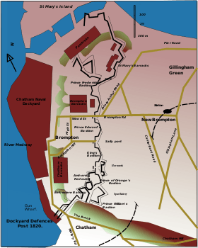
Brompton dates back to the late 17th century, and grew rapidly in the 18th century to accommodate the fast-growing dockyard workforce. It was a deliberately planned settlement, laid out by Thomas Rogers, Esquire, the owner of Westcourt Manor on whose demense lands it was built. In the 1750s, with the building of the Chatham Lines to defend Chatham Dockyard, the village became completely surrounded by military establishments, limiting its ability to expand much beyond its original plan. When war with France recommenced in 1778, it was necessary to strengthen the dockyard defences. Fort Amherst and the Chatham Lines (defensive ditches) were improved and extended, and work was later begun on additional perimeter forts in Chatham and Rochester. The Barracks – still in existence today – were built to house the soldiers. This, and the expansion of the dockyard, meant that more homes were needed for the workers. The position of the Chatham Lines meant that eventually building could only happen to the east of the defensive ditch, and so New Brompton came into being. The population rose to 9,000 by 1851.
From the 1850s, following the building of New Brompton & Gillingham Station, and the subsequent expansion of the town of New Brompton (Gillingham), the original settlement of Brompton became known as Old Brompton. From the late 19th century the importance of Old Brompton as a commercial center began to decline, finally being destroyed in the 1950s and 1960s when redevelopment by Gillingham Council tore down the main 18th & 19th century shopping streets (High Street, Wood Street, Middle Street), replacing shops with council housing, leaving just a handful of shops at the southern end of the High Street. The closure of Chatham Dockyard in 1984 spelled the end for several of the shops and pubs that did manage to survive the Council redevelopments.
Gillingham Green was a small village;[1] eventually it, too, was swallowed up, and the name of the whole settlement changed to Gillingham.
Officers' houses were built within the confines of the Barracks and at Brompton where Mansion Row, Prospect Row and Garden Street now form part of the Brompton-Lines conservation area. New Brompton was the name originally given to Gillingham station on the Chatham Main Line. New Brompton was the original name of Gillingham F.C. Founded in 1893 it changed its name in 1913.
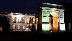
Brompton Barracks has been home to the Royal Engineers since 1812, and now houses the Royal Engineers Museum. The Royal School of Military Engineering (RSME) is based at Brompton Barracks
Also Brompton is also part of the Chatham Dockyard World Heritage bid.[2]
Gallery
- Prospect Row
- Mansion Row
 HQ Royal School of Military Engineering
_-_geograph.org.uk_-_1148711.jpg)
 Showing Brompton and New Brompton, and their relationship to Chatham Dockyard, and the Lines
References
- ↑ John Cumins. "History – Gillingham Parish Church, Kent". gillinghamparishchurch.org.uk. Retrieved 1 October 2012.
- ↑ "Chatham's bid for World Heritage Status". chathamworldheritage.co.uk/. Retrieved 1 October 2012.
External links
- Royal Engineers Museum
- Corps of Royal Engineers Website
- Official Royal School of Military Engineering website
- Holdfast Training Services
- Chatham's World Heritage Site application
| Wikimedia Commons has media related to Brompton. |
