Zidani Most
| Zidani Most | |
|---|---|
 | |
 Zidani Most Location in Slovenia | |
| Coordinates: 46°5′16″N 15°10′25″E / 46.08778°N 15.17361°ECoordinates: 46°5′16″N 15°10′25″E / 46.08778°N 15.17361°E | |
| Country |
|
| Traditional region | Styria |
| Statistical region | Savinja |
| Municipality | Laško |
| Area | |
| • Total | 0.76 km2 (0.29 sq mi) |
| Elevation | 204.5 m (670.9 ft) |
| Population (2011)[1] | |
| • Total | 284 |
| • Density | 372/km2 (960/sq mi) |
| Website | www.zidanimost.si |
| [2] | |
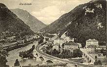
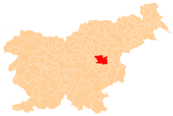
Zidani Most (pronounced [ˈziːdani ˈmoːst]; German: Steinbrück) is a settlement in the Municipality of Laško in eastern Slovenia. It lies at the confluence of the Sava and Savinja rivers. The area was traditionally part of the Styria region. It is now included with the rest of the municipality in the Savinja Statistical Region.[3] It is an important railway station and junction.[4]
Name
The name Zidani Most literally means 'stone bridge'. The settlement was attested in 1224 as Lapideo Ponti (and as trans Pontem in 1230, bey der Gemauertten Prucken in 1457–61, and an der Stainen Prukken in 1470).[5] The name refers to a stone bridge built at the site in 1224 by Leopold VI. The bridge was destroyed in battles between Emperor Frederick III and the Counts of Celje in 1442.[6]
Main sights
Bridges

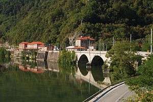
A bridge already crossed the Sava in the area in 20 BC, in the Roman period, linking the towns of Emona, Celeia, and Neviodunum. The current road stone bridge over the Savinja was built by order of Archduke John of Austria[5] in 1824–26 following plans by the engineer Friedrich Byloff and linked the town of Celje and the Lower Sava Valley.[7] The old railroad bridge that still stands was built in 1846–49 from 1,260 stone blocks to the plans of the engineer Eduard Heider. Its construction was technically very demanding, because it had to follow a curve.[8] Similarly technically demanding was the construction of the new reinforced concrete railroad bridge, built by the Slavec company from Kranj in 1929–30.[9]
Church
The local church, built in the eastern part of the settlement known as Vila, is dedicated to the Sacred Heart of Jesus and belongs to the Parish of Marija Širje. It was built in 1920.[10]
See also
References
- ↑ "Zidani Most". Place Names. Statistical Office of the Republic of Slovenia. Retrieved 23 June 2012.
- ↑ Statistical Office of the Republic of Slovenia Archived November 18, 2008, at the Wayback Machine.
- ↑ Laško municipal site
- ↑ Slovenian Railways site
- 1 2 Snoj, Marko. 2009. Etimološki slovar slovenskih zemljepisnih imen. Ljubljana: Modrijan and Založba ZRC, p. 481.
- ↑ Rojc, Emil (ed.). Radeče: z dediščino preteklosti, utripom sedanjosti in izzivi prihodnosti [Radeče: With the Heritage of the Past, the Pulse of the Present, and the Challenges of the Future]. Municipality of Radeče. pp. 30–62. COBISS 242909696.
- ↑ Kemperl, Metoda; Golec, Boris; Klemenčič, Matej; et al., eds. (2010). "ZIDANI MOST, cesta in most" [ZIDANI MOST, the road and the bridge]. Arhivski viri za urbanistično in arhitekturno zgodovino na Slovenskem (16.-19. stoletje) [Archival Sources for the History of Urban and Architectural History of the Slovene Lands (16th–19th Century) (in Slovenian). OK Informatika. Retrieved 23 June 2012.
- ↑ Mlinar, Ivan (1956). "Zidani most v zgodovini" [Zidani Most in History]. Kronika (in Slovenian). Section for the History of Places, Association of Historical Societies of Slovenia. 4 (2): 67–76. ISSN 0023-4923.
- ↑ Jenko, Jože (1962). "Med Zidanim Mostom in Siskom vozijo vlaki že 100 let" [Trains Drive Between Zidani Most and Sisak Already 100 Years]. Kronika (in Slovenian). Section for the History of Places, Association of Historical Societies of Slovenia. 10 (2): 103. ISSN 0023-4923.
- ↑ Slovenian Ministry of Culture register of national heritage Archived July 12, 2010, at the Wayback Machine. reference number ešd 4163
External links
| Wikimedia Commons has media related to Zidani Most. |
- Zidani Most on Geopedia Map and geodetic information about the settlement.
- Official site
