Zabalgana
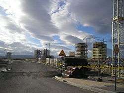
Zabalgana Is a neighbourhood of the city of Vitoria, Basque Country, Spain.[1] Still under construction, when it was finalised neighbourhood in his group expects that it was inhabited by more than 30.000 people. It is, beside Salburua, one of the urban expansions of the city of finals of the 20th century.
Geography
It is situated in the extreme southwest of the city, limiting west with the forest of Zabalgana, the south with the mountain of Armentia, the east with the neighbourhood of Ariznavarra and north with Ali and Sansomendi neighbourhoods.
Demography
According to data of the city council, the neighbourhood had the 1 January of the 2012 a population of 16 973 inhabitants and the foreign population increased to 10,9%.[2] In the year 2011, the total population was 14 232 people (5,9% of the municipality), resulting a density of population of 3997,6 hab./Km² and the age average was of 30,9 years (2010).
Division
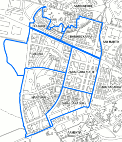
According to the General Plan of Urban Ordination of the Municipality, in December 2000, the district is divided in 6 urbanistic sectors, numbered from 1 to 6:[3]
| Sectors | Name | Surface | Total of houses | Official protection | Free |
|---|---|---|---|---|---|
| 1 | Borinbizkarra | 343.505 m2 | 2.000 | 1.568 | 432 |
| 2 | North Zabalgana |
377.281 m2 | 1.711 | 1.283 | 428 |
| 3 | South Zabalgana |
262.459 m2 | 963 | 502 | 461 |
| 4 | Elejalde | 149.430 m2 | 800 | 538 | 262 |
| 5 | Aldaia | 651.036 m2 | 2.621 | 1.967 | 654 |
| 6 | Mariturri | 700.960 m2 | 4.133 | 3.391 | 742 |
- Zabalgana Centre / Zone consolidated: Part of the neighbourhood that is already finished. There are already around 8.000 inhabitants and it is supposed to surpass de quantity of 10.000. Its main zones are the Avenue Queen Sofia, the Avenue of the Human Rights and the Avenue of Zabalgana. The houses do not surpass generally the 6 floors. It stands out the step of the river Ali from the middle of its streets.
- Mariturri: It is a sector that was built during the years 2008, 2009 and 2010. It is situated in the extreme south of the neighbourhood and stands out by his Portificada square (in styles of the 19th centuries greater squares) and his distinguishable towers of 12 and 15 flats.
- Aldaia: It is a sector still under construction and with an increasing number of inhabitants. It is the nearest part from the forest of Zabalgana, and could arrive to a number 10.000 people when it will be finalised.
- Elejalde And Borinbizkarra: The 2 sectors that were finished building in the year 2012, whose location is own north of the road of the railway, limit with Ali and Sansomendi.
Referencias
- ↑
- ↑ La Población de Vitoria-Gasteiz al 1/1/2012 y los movimientos demográficos del último año
- ↑ Ayuntamiento de Vitoria-Gasteiz. "Ensanche 21 - Áreas de Actuación - Zabalgana" (in Spanish). Retrieved 22 June 2011.
External links
Coordinates: 42°50′44″N 2°42′10″W / 42.8455°N 2.7027°W