Vuyyuru mandal
| Vuyyuru mandal మచిలీపట్టణం మండలం | |
|---|---|
| Mandal | |
|
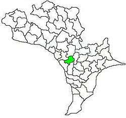
Mandal map of Krishna district showing Vuyyuru mandal (in yellow) | |
 Vuyyuru mandal Location in Andhra Pradesh, India | |
| Coordinates: 16°22′N 80°51′E / 16.367°N 80.850°ECoordinates: 16°22′N 80°51′E / 16.367°N 80.850°E | |
| Country | India |
| State | Andhra Pradesh |
| District | Krishna |
| Headquarters | Vuyyuru |
| Area[1] | |
| • Total | 103.18 km2 (39.84 sq mi) |
| Population (2011)[2] | |
| • Total | 76,703 |
| • Density | 740/km2 (1,900/sq mi) |
| Languages | |
| • Official | Telugu |
| Time zone | IST (UTC+5:30) |
Vuyyuru mandal is one of the 50 mandals in Krishna district of the Indian state of Andhra Pradesh. It is under the administration of Nuzvid revenue division and the headquarters are located at Vuyyuru town.[3][1] The mandal is bounded by Kankipadu, Unguturu, Thotlavalluru, Pedaparupudi and Pamidimukkala mandals.[4]
Towns and villages
As of 2011 census, the mandal has 13 villages.[3][1]
The settlements in the mandal are listed below:
- Akunuru
- Bollapadu
- China Ogirala
- Jabarlapudi
- Kadavakollu
- Mudunuru
- Peda Ogirala
- Saipuram
- Veeravalli Mokhasa
- Vuyyuru
- Katuru
- Kalavapamula
- Ramachandrapuram
- Gandigunta
See also
References
- 1 2 3 "District Census Handbook - Krishna" (PDF). Census of India. p. 16,412. Retrieved 7 February 2016.
- ↑ "Census 2011". The Registrar General & Census Commissioner, India. Retrieved 27 May 2015.
- 1 2 "Krishna District Mandals" (PDF). Census of India. pp. 510,530. Retrieved 19 January 2015.
- ↑ "Mandals in Krishna district". aponline.gov.in. Retrieved 12 September 2014.
 |
Kankipadu mandal | Unguturu mandal | Pedaparupudi mandal |  |
| Thotlavalluru mandal Kankipadu mandal |
|
Pedaparupudi mandal | ||
| ||||
| | ||||
| Thotlavalluru mandal | Pamidimukkala mandal | Pedaparupudi mandal |
This article is issued from Wikipedia - version of the 9/23/2016. The text is available under the Creative Commons Attribution/Share Alike but additional terms may apply for the media files.
