Uphill
Coordinates: 51°19′23″N 2°58′38″W / 51.3231°N 2.9773°W
Uphill is a village in the civil parish of Weston-super-Mare in North Somerset, England, at the southern edge of the town, on the Bristol Channel coast.
History
The toponym, recorded in Domesday Book as Opopille, derives from the Old English uppan pylle, meaning "above the creek", referring to the mouth of the Axe.[1]
There is evidence of a port at Uphill since Roman times, probably for the export of lead from the Mendip Hills.[2] The mouth of the River Axe is sheltered by Brean Down. The small quay at Uphill fell under the limited jurisdiction of the Port of Bristol, however it was a free port as it did not have the customs officers to collect revenues which were present at larger ports. In 1591 the captured French ship the Gray Honde from Bayonne was brought into Uphill, however; the normal trade from the 16th century was in livestock, brought from South Wales to be fattened on the local rich grassland.[3] During the English Civil War the port was used to bring two regiments, about 1,500 men, of the Royalist Army from South Wales before the Battle of Langport.[4] It continued as a small landing stage for many centuries including the import of coal and iron and the export of local produce.[5] After the Enclosure Act of 1813 a public wharf was constructed for trade and was also used occasionally by passenger excursion ships.[3]
The Bristol to Exeter railway line runs through a steep cutting between Uphill and nearby Bleadon. This cutting is spanned by a high brick bridge known as "Devil's Bridge" and designed by Isambard Kingdom Brunel. The former Bleadon and Uphill railway station served the village from 1871 until 1964.
The parish was part of the Winterstoke Hundred.[6] The parish became a civil parish in 1866. In 1933 the civil parish was abolished and absorbed into Weston-super-Mare.[7]
Geography
Uphill is situated at the south end of Weston Bay, where the River Axe flows into the Bristol Channel, and was once a busy port. The Mendip Way long-distance footpath has its western trailhead at Uphill near the wharf.
The village is dominated on its southern side by a large hill, the southern slope of which and the quarry at its western end form the Uphill Cliff Site of Special Scientific Interest, notable for its species-rich calcareous grassland. It consists of species-rich calcareous grassland and rock-face situated on Carboniferous Limestone. Steeper banks and knolls in the grassland have a flora which includes orchids, Somerset Hair Grass (Koeleria vallesiana), and Honewort (Trinia glauca), and the Goldilocks Aster (Galatella linosyris) along with several species of butterfly and Weevil (Curculionoidea).[8] The hill and Walborough common, which are adjacent to each other, are local nature reserves making a total area of 38.14 hectares (94.2 acres). There are a range of flowers including cowslip, primrose and green-winged orchid.[9] The Salt marsh has sea barley, slender hare's-ear and sea clover and limestone grassland with Somerset hair-grass, honewort, green-winged and early purple orchids. These attract redshank, dunlin, shelduck, black-tailed godwit, skylark, linnet, rock and meadow pipit.[10]
A tower on the hill is the remains of a 14th-century windmill.
Religious sites
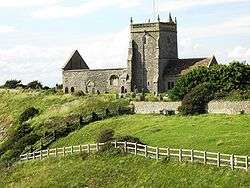
On top of the hill stands the unroofed Norman Old Church of St Nicholas". It is now in the care of the Churches Conservation Trust.[11]
The present day Church of St Nicholas is situated on lower ground towards the north end of the village.[12]
Public services
Uphill is home to Weston General Hospital. Weston Hospicecare, a hospice providing palliative care to patients from the surrounding area with terminal illnesses, is also based here.
References
- ↑ Watts, Victor, ed. (2010), "Uphill", The Cambridge Dictionary of English Place-Names, Cambridge University Press
- ↑ Newman, Paul (1976). Channel Passage. Kingsmead Press. p. 58. ISBN 0901571741.
- 1 2 Body, Geoff; Gallop, Roy (2015). Any Muddy Bottom: A History of Somerset's Waterborne Trade. History Press. pp. 88–91. ISBN 9780750961639.
- ↑ Barratt, John (2005). The civil war in the south west. Barnsley: Pen & Sword Military. p. 116. ISBN 1-84415-146-8.
- ↑ Farr, Grahame (1954). Somerset Harbours. London: Christopher Johnson. p. 65.
- ↑ "Somerset Hundreds". GENUKI. Retrieved 9 September 2011.
- ↑ Vision of Britain website
- ↑ "Uphill Cliff" (PDF). English Nature's SSSI Information. Retrieved 27 January 2007.
- ↑ "Uphill Hill Local Nature Reserve, Nr Weston super Mare". Avon Local Nature Reserves. Retrieved 26 August 2015.
- ↑ "Walborough". Avon Wildlife Trust. Retrieved 26 August 2015.
- ↑ "St Nicholas, Uphill". Churches Conservation Trust. Retrieved 22 July 2010.
- ↑ "Uphill Church of St Nicholas". Images of England. Retrieved 25 September 2007.
External links
| Wikimedia Commons has media related to Uphill, Somerset. |


