Transportation in Charlotte, North Carolina
The transportation needs for the city of Charlotte, North Carolina are served by an expanding mass transit system, major airport, and several highways.
Mass transit

The Charlotte Area Transit System (CATS) is the agency responsible for operating mass transit in Charlotte, and Mecklenburg County.
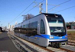
CATS operates light rail transit, historical trolleys, express shuttles, and bus service serving Charlotte and its immediate suburbs. The LYNX light rail system comprises a 9.6-mile line north-south line known as the Blue Line. Bus ridership continues to grow (66% since 1998), but more slowly than operations increases which have risen 170% in that same time when adjusted for inflation.[1]
The 2030 Transit Corridor System Plan looks to supplement its established bus service with light rail & commuter rail lines called LYNX. Designed to carry passengers along five key corridors, the project is estimated to cost $8.9 billion. $4.6 billion are capital costs and $4.3 billion are operating costs through 2035. Originally, before the 1998 ballot referendum, the plan had been forecast to cost $1.1 billion.[2]
Air

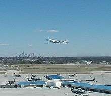
Charlotte/Douglas International Airport is the 11th busiest airport in the world, as measured by traffic[3] It is served by many domestic airlines, as well as international airlines Air Canada and Lufthansa, and is the second largest hub for American Airlines. Nonstop flights are available to many destinations across the United States, as well as flights to Canada, Central America, the Caribbean, Europe, Mexico, and South America.
Roads and highways
Charlotte's central location between the population centers of the northeast and southeast has made it a transportation focal point and primary distribution center, with two major interstate highways, I-85 and I-77, intersecting near the city's center. Charlotte's beltway, designated I-485, is simply called "485" by locals and has a total circumference of approximately 67 miles (108 km). Within the city, the I-277 loop freeway encircles Charlotte's downtown (usually referred to by its two separate sections, the John Belk Freeway and the Brookshire Freeway) while Charlotte Route 4 links major roads in a loop between I-277 and I-485.
Trade Street and Tryon Street are the central thoroughfares though Uptown Charlotte. The intersection of Trade and Tryon marks the center point of the city, dividing the city's first four wards.
Other major thoroughfares include: Albemarle Road (part of NC 24 and NC 27), Arrowood Road, Atando Avenue, Beatties Ford Road, Billy Graham Parkway, Brookshire Boulevard (part of NC 16), Carson Boulevard, Central Avenue, Charlottetowne Avenue, Clanton Road, Davidson Street, East Boulevard, Eastway Drive, Elizabeth Avenue, Fairview Road, Freedom Drive (part of NC 27), Graham Street (part of US 29 and NC 49), Hawthorne Lane, Idlewild Road, Independence Boulevard (part of US 74 and NC 27), Johnston Road, Kenilworth Avenue, Kings Drive, LaSalle Street, Lawyers Road, Little Rock Road, Mallard Creek Road, McDowell Street (part of NC 27), Mint Street, Monroe Road, Morehead Street (part of US 29 and NC 27), Mt. Holly Road (part of NC 27), Nations Ford Road, Nevin Road, Oaklawn Avenue, Park Road, Pineville-Matthews Road (part of NC 51), The Plaza, Providence Road (part of NC 16), Queens Road, Randhiolph Road, Rea Road, Remount Road, Rozzelles Ferry Road, Runnymeade Lane, Sardis Road, Scaleybark Road, Selwyn Avenue, Sharon Road, Sharon-Amity Road, South Boulevard, Statesville Road (part of US 21), Steele Creek Road (part of NC 160), Stonewall Street, Sugar Creek Road, Sunset Road, Tremont Avenue, Tuckaseegee Road, Tyvola Road, University City Boulevard (part of NC 49), W.T. Harris Boulevard (part of NC 24), Wendover Road, West Boulevard (part of NC 160), Westinghouse Boulevard, Wilkinson Boulevard (part of US 74) and Woodlawn Road.
Intercity rail
Charlotte is served daily by three Amtrak routes.
The Crescent train connects Charlotte with New York, Philadelphia, Baltimore, Washington, Charlottesville, and Greensboro to the north, and Atlanta, Birmingham and New Orleans to the south.
The Carolinian train connects Charlotte with New York, Philadelphia, Baltimore, Washington, Richmond, Raleigh, Durham and Greensboro.
The Piedmont train connects Charlotte with Raleigh, Durham and Greensboro.
The Charlotte Amtrak station is located at 1914 North Tryon Street.
The city is currently building a new centralized multimodial train station called the Gateway Station. It is expected to house the future LYNX Purple Line, the new Greyhound bus station, and the Crescent line that passes through Uptown Charlotte.
References
External links
![]() Media related to Transport in Charlotte, North Carolina at Wikimedia Commons
Media related to Transport in Charlotte, North Carolina at Wikimedia Commons