Timanfaya National Park
| Timanfaya National Park | |
|---|---|
| Parque Nacional de Timanfaya | |
|
IUCN category II (national park) | |
 | |
_-_OSM_Mapnik.svg.png) Timanfaya National Park (shaded green) | |
| Location | Lanzarote, Spain |
| Coordinates | 29°00′N 13°44′W / 29.000°N 13.733°WCoordinates: 29°00′N 13°44′W / 29.000°N 13.733°W |
| Area | 51.07 km2 (19.72 sq mi) |
| Established | 1974 |
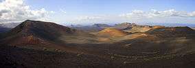
Timanfaya National Park (Spanish: Parque Nacional de Timanfaya) is a Spanish national park in the southwestern part of the island of Lanzarote, Canary Islands. It covers parts of the municipalities Tinajo and Yaiza. The area is 51.07 square kilometres (19.72 sq mi).[1] The parkland is entirely made up of volcanic soil. The statue "El Diablo" by César Manrique is its symbol.
Volcanic activity
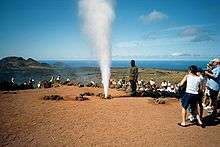
The greatest recorded eruptions occurred between 1730 and 1736. The volcanic activity continues as the surface temperature in the core ranges from 100 to 600 °C at the depth of 13 metres (43 ft), which is demonstrated by pouring water into the ground, resulting in a geyser of steam which is an attraction for tourists. There is only one active volcano, Timanfaya volcano which the park is named after.
 Charco de los Ciclos
 Timanfaya
- Timanfaya
Ecological value
In 1993, UNESCO designated a Biosphere reserve covering the whole of Lanzarote. The national park is one of the core areas of the biosphere reserve.
Access to the park by the public is strictly regulated to protect the delicate flora and fauna. There are one or two footpaths, and a popular short route where one can visit by camel. There is a public car park from which one can tour the volcanic landscape by coach using a road that is otherwise closed to the public.

References
External links
 Media related to Parque Nacional de Timanfaya at Wikimedia Commons
- http://reddeparquesnacionales.mma.es/en/parques/timanfaya/index.htm
- More Information and how to get there