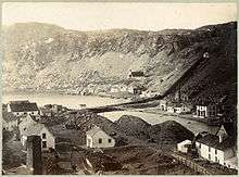
Tilt Cove
| Tilt Cove | |
|---|---|
| Town | |
| Coordinates: 49°53′10″N 55°37′37″W / 49.88611°N 55.62694°W | |
| Country |
|
| Province |
|
| Population (2011) | |
| • Total | 5 |
| Time zone | Newfoundland Time (UTC-3:30) |
| • Summer (DST) | Newfoundland Daylight (UTC-2:30) |
| Area code(s) | 709 |
Tilt Cove (/tɪlt koʊv/) is a town located southeast of Baie Verte on Notre Dame Bay and was founded in 1813. The mine at Tilt Cove, the first in Newfoundland,[1] was opened in 1864 and "was soon employing several hundred men at good wages".[2] The Post or Way Office was established in 1869. The population was 1,370 in 1901 and 57 by 1956. It has a population of 5 as of 2011 according to Statistics Canada, but another source gives the population as 7.[3] Ores found at Tilt Cove are gold, copper, and zinc. [4]

History
Settled around 1813 or earlier by George and Mary Winsor from the West Country England, Tilt Cove was a tiny fishing settlement with a population of about 25. In 1857, Smith McKay discovered rich deposits of copper ore and in 1864, in conjunction with C.F. Bennett, began mining operations. In the 1880s, the Tilt Cove mine changed ownership to the Cape Copper Company.[5] In 1916, the population peaked to 1500.
In 1892, the Newfoundland Colonist, a newspaper, described Tilt Cove as "the leading town in Notre Dame Bay, with the sides, top and bottom of the mines being one solid mass of copper, looking as if it would be everlasting". On the afternoon at approximately tea-time on 11 March 1912, there was an avalanche at Tilt Cove in which there were 5 injuries and 5 fatalities. The funerals for the victims took place on 14 March 1912. [6]
The town was once very prosperous but there was a time, like now, when it was not. In 1920 the mines closed and the population dropped to around 100 and remained that way until the mines reopened in 1957. The Tilt Cove mine was reopened by Canadian mining promoter Matthew James Boylen as a result of Newfoundland and Labrador government policy to encourage mineral exploration and revitalize mining communities and Tilt Cove experienced a rebirth. [7] In 1967 the mines closed down not to re-open until modern mining activity began.
The Queen of Swansea Memorial, which is located in Tilt Cove, was erected in memory of the passengers and crew who perished on Gull Island following the sinking of the vessel Queen of Swansea. This was the ship which transported copper ore from Tilt Cove to Wales.
Recent Mining Activity
On 7 July 1999, Cabo Mining entered into an agreement with the Tilt Cove Mining Company regarding its property in Tilt Cove resulting in Cabo Mining acquiring a 100% interest in the property subject to a 3% NSR by paying a combination of shares and 1.27 million Canadian dollars to Tilt Cove.[8]
On 23 May 2008, surface sampling returned gold (up to 69.39 g/t) and copper (up to 10.4%) assays from surface grab samples.[9]
The current owner of the Tilt Cove mine is Metals Creek, which negotiated terms to process surface material remaining at Tilt Cove. "Transportation of the Tilt Cove stockpile to the Nugget Pond Mill began on June 7th, 2011 with subsequent processing of the ore beginning on June 10th, 2011. 20,882 wet metric tonnes of material was processed at a grade of 1.79 g/t gold. This processing resulted in a $173,372 NSR payment from Rambler Mining to Metals Creek Resources as well as roughly 20,000 to 30,000 tonnes of material still remaining in the stockpile." Ongoing work is in progress to produce a 3D model of the Tilt Cove Mine. [10]
See also
References
- ↑ Rowe, Frederick (1980). A History of Newfoundland and Labrador. Canada: McGraw-Hill Ryerson Limited. p. 14. ISBN 0-07-092397-3.
- ↑ Rowe, Frederick (1980). A History of Newfoundland and Labrador. Canada: McGraw-Hill Ryerson Limited. p. 291. ISBN 0-07-092397-3.
- ↑ Chittley, Jordan (October 2, 2013). "Residents of Canada's smallest town seek to delay the inevitable A former mining town in Newfoundland is down to its final seven people". Yahoo Canada News. Retrieved October 2, 2013.
- ↑ "Tilt Cove". InfoMine Company & Property Mining Intelligence. Retrieved May 26, 2014.
- ↑ "Tilt Cove Avalanche". Department of Natural Resources, Newfoundland and Labrador. Retrieved May 26, 2014.
- ↑ "Tilt Cove Avalanche". Department of Natural Resources, Newfoundland and Labrador. Retrieved May 26, 2014.
- ↑ Rowe, Frederick (1980). A History of Newfoundland and Labrador. Canada: McGraw-Hill Ryerson Limited. p. 501. ISBN 0-07-092397-3.
- ↑ "Tilt Cove". InfoMine Company & Property Mining Intelligence. Retrieved May 26, 2014.
- ↑ "Tilt Cove". InfoMine Company & Property Mining Intelligence. Retrieved May 26, 2014.
- ↑ "Tilt Cove - NFLD". Metals Creek. Retrieved May 26, 2014.
Further reading
- Ommer, Rosemary E; Coasts Under Stress Research Project team (2007). Coasts under stress : restructuring and social-ecological health / Rosemary E. Ommer and the. Montreal: McGill-Queen's University Press,. pp. xvii, 574 p. : ill., maps ; 24 cm. line feed character in
|title=at position 41 (help) ISBN 9780773532038 (bound), ISBN 9780773532250 (pbk.)
Coordinates: 49°53′10″N 55°37′37″W / 49.88611°N 55.62694°W