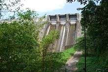
Thenmala Dam
| Thenmala Dam | |
|---|---|
 Thenmala Dam | |
 Location of Thenmala Dam in India Kerala | |
| Official name | Kallada dam |
| Location | Kollam District, Kerala |
| Coordinates | 08°57′00″N 77°04′20″E / 8.95000°N 77.07222°ECoordinates: 08°57′00″N 77°04′20″E / 8.95000°N 77.07222°E |
| Purpose | Irrigation |
| Status | Operational |
| Opening date | 1986 |
| Dam and spillways | |
| Height | 85.35m |
| Length | 335m |
| Spillways | 3 |
| Spillway type | Ogee with radial gate auxiliiary- Labyrinth |
| Reservoir | |
| Total capacity | 524,000,000 m3 (424,814 acre·ft) |
| Active capacity | 507,000,000 m3 (411,032 acre·ft) |
| Catchment area | 549 km2 (212 sq mi) |
| Surface area | 23 km2 (9 sq mi) |
The Thenmala dam is the second largest irrigation project in Kerala, India. It impounds the longest reservoir in the state and water from the reservoir is also used for power generation.
The dam was started in 1961 under the Kallada Irrigation and Tree Crop development project with an original cost of Rs. 13.28 crores. The revised estimate of Rs. 728 crores at the 1999 schedule of rates made the cost escalation to be reported at 5,356 per cent. The ayacut[1] targeted was 61630 hectares (net) and 92800 hectares (gross).[2] Though the project was targeted for completion, and priority in allocation was given during Ninth Plan, it could not be completed and commissioned fully.[3]
It is now a centre of attraction at Thenmala and an ecotourism destination, with boating available on the reservoir, which is bordered on both sides by the Shendurney Wildlife Sanctuary.[4]
See also

References
- ↑ ayacut: The area served by an irrigation project such as a canal, dam or a tank.
- ↑ "Kerala Irrigation Department". Retrieved 19 September 2014.
- ↑ "www.kollam.nic.in". Retrieved 19 September 2014.
- ↑ "Thenmala - India's first planned Eco-Tourism, Kollam - Kerala Tourism". Retrieved 20 September 2014.
External links
| Wikimedia Commons has media related to Thenmala dam. |