Texas State Highway 123
| ||||
|---|---|---|---|---|
 | ||||
| Route information | ||||
| Maintained by TxDOT | ||||
| Length: | 69.10 mi[1] (111.21 km) | |||
| Existed: | by 1933[1] – present | |||
| Major junctions | ||||
| South end: |
| |||
| North end: |
| |||
| Highway system | ||||
| ||||
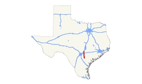
State Highway 123 is a north–south state highway that extends from Interstate 35 in San Marcos to US 181 in Karnes City. The route was initially proposed in 1928 and has had minimal changes to its routing since then.
Route description
SH 123 begins at an intersection with US Route 181 just south of Karnes City and proceeds northward along the town's eastern edge. The route intersects the Business Route of US 181 and Texas State Highway 80 as it passes through town. The road continues north through farmlands before reaching an intersection with US Route 87 in Stockdale. The route continues north through ranchlands until Seguin. Reaching Seguin, Texas State Highway 46 begins, peeling off to the northwest toward New Braunfels. SH 123 continues around the eastern edge of Seguin, where it is known locally as "the Bypass", and there it intersects US 90 Alt., US 90, and Interstate 10. The highway continues north, reaching its northern terminus at Interstate 35 in San Marcos.
The route has two business segments: Business 123-B, largely on Austin St, through historic downtown Seguin, and Business 123-D in Karnes City.
Route history
The route was initially proposed in 1928 from Stockdale to San Marcos with a proposed extension south to Karnes City. By 1940 the southern extension was completed, but was still unpaved. Paving was completed in the mid-1940s.
Major intersections
| County | Location | mi | km | Destinations | Notes |
|---|---|---|---|---|---|
| Karnes | | south end of US 181 Bus. / SH 80 overlap | |||
| Karnes City | north end of US 181 Bus. overlap | ||||
| north end of SH 80 overlap | |||||
| | |||||
| | south end of FM 81 overlap | ||||
| | north end of FM 81 overlap | ||||
| Pawelekville | |||||
| Wilson | | ||||
| | |||||
| | |||||
| Stockdale | interchange | ||||
| | |||||
| | |||||
| Guadalupe | | ||||
| Seguin | |||||
| I-10 exit 610 | |||||
| Geronimo | |||||
| | |||||
| | |||||
| | |||||
| | |||||
| | |||||
| Hays | San Marcos | ||||
| 1.000 mi = 1.609 km; 1.000 km = 0.621 mi | |||||
References
- 1 2 Transportation Planning and Programming Division (n.d.). "State Highway No. 123". Highway Designation Files. Texas Department of Transportation. Retrieved 2010-06-15.
