Tell Tweini
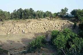
 City wall of Tell Tweini | |
 Shown within Syria | |
| Location | Latakia Governorate, Syria |
|---|---|
| Region | Levant |
| Coordinates | 35°22′18″N 35°56′11″E / 35.37167°N 35.93639°ECoordinates: 35°22′18″N 35°56′11″E / 35.37167°N 35.93639°E |
| Type | Settlement |
| Site notes | |
| Condition | In ruins |
Tell Tweini is an archaeological site located 1 kilometre east of the modern city of Jableh, Syria. It is situated within the coastal plain of Jableh, a short distance of two other main archaeological sites: Tell Sukas (5 km) and Tell Siyannu (6 km). As a tell, the site is the result of centuries of habitation on the same place, which resulted in a rising mound, as every new generation built their houses on top of the remains of older structures.
History

Tell Tweini was inhabited from at least the end of the third millennium BCE until the Persian period. The town may have been ancient Gibala, a city mentioned in a treaty found at Ugarit (modern Ras Shamra) from the 13th century BCE.
Middle Bronze Age
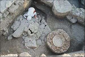
An extraordinary find at Tell Tweini was the communal tomb dating to ca 1700 BCE.
The grave contained the skeletons of 42 adults and 16 infants. Serving as grave-goods were 160 well-preserved ceramic vessels, plates and dishes, several bronze pins and a figurine. .. Among others, the grave goods included a fenestrated axe, quite typical for this period. Similar axes have also been discovered at Sukas, Ugarit and Byblos.[1]
Late Bronze Age
At the end of the Late Bronze Age Gibala formed the southern border of the Ugaritic kingdom. The transition between the Late Bronze Age and Iron Age remains as at most northern Levantine site's problematic, but preliminary results from the end of the 2007 campaign show the city was inhabited during the 11th-10th century BCE. During the Iron Age itself, the city was completely urbanised. A geophysical prospection conducted on the complete surface of the tell proofs this and made it possible to detect the ancient street system of the Iron Age city. By the Perisian era the city lost its importance and the habitation was relocated near the modern harbour of Jebleh at the Mediterranean sea coast. Later, during the Byzantine domination of the region some isolated structures were installed on the surface of the tell.
Archaeology
Tell Tweini is being investigated since 1999 by a Syro-Belgian interdisciplinary team led by Michel al-Maqdissi, Joachim Bretschneider and Karel Van Lerberghe.[2]
Since excavations started in 1999, major discoveries include a Phoenician sanctuary, a large communal tomb from the end of the Middle Bronze Age containing 58 human remains, a large city wall, several domestic and public structures from the Iron Age I-II and multiple small finds. The coming years research on the tell will be continued.
Notes
- ↑ The Syro-Belgian Excavations of Tell Tweini (PDF) telltweini.com
- ↑ Joachim Bretschneider and Karel Van Lerberghe, In search of Gibala. An Archaeological and Historical Study based on Eight Seasons of Excavations at Tell Tweini (Syria) in the A and C fields (1999-2007), Aula Orientalis Supplementa, vol. 24, 2008, ISBN 978-84-88810-79-3
See also
- Short chronology timeline - one of the chronologies of the Near Eastern Bronze and Early Iron Age
References
- Bretschneider, J., Van Lerberghe, K. (2009). An Archaeological and Historical Study Based on Eight Seasons of Excavations at Tell Tweini (Syria) in the A and C Fields. The Syro-Belgian 'Tell Tweini' Project (1999–2007). In: In Search of Gibala. Barcelona: AUSA. Michel al-Maqdissi, Karel Van Lerberghe et al., The Occupation Levels of Tell Tweini and Their Historical Implications, in Proceedings of the 51st Rencontre Assyriologique Internationale, Oriental Institute SAOC 62, pp. 341–350, 2005