Steghorn
| Steghorn | |
|---|---|
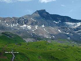 The north side | |
| Highest point | |
| Elevation | 3,146 m (10,322 ft) |
| Prominence | 266 m (873 ft) [1] |
| Parent peak | Wildstrubel |
| Coordinates | 46°25′0″N 7°35′3″E / 46.41667°N 7.58417°ECoordinates: 46°25′0″N 7°35′3″E / 46.41667°N 7.58417°E |
| Geography | |
 Steghorn Location in Switzerland | |
| Location | Bern/Valais, Switzerland |
| Parent range | Bernese Alps |
| Climbing | |
| Easiest route | From "Lämmeren" hut, Valais |
The Steghorn is a mountain of the Bernese Alps, located on the border between the Swiss cantons of Bern and Valais. It lies between the Engstligenalp (Bernese Oberland and the Gemmi Pass (Valais). The Steghorn belongs to the massif of the Wildstrubel.
The easiest ascent can be made from the "Lämmeren" hut in the canton of Valais via the Steghorn glacier or the Leiterli rocks. Another route leads from Engstligenalp along the ridge between Steghorn and Wildstrubel.
The mountain can also be ascended from both sides during wintertime, yet the skiing tour is very challenging.
References
- ↑ Retrieved from the Swisstopo topographic maps and Google Earth. The key col is located west of the summit at 2,880 metres.
External links
| Wikimedia Commons has media related to Steghorn. |
This article is issued from Wikipedia - version of the 5/9/2016. The text is available under the Creative Commons Attribution/Share Alike but additional terms may apply for the media files.