Sierra del Rosario
| Sierra del Rosario Biosphere Reserve | |
|---|---|
|
IUCN category IV (habitat/species management area) | |
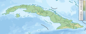
 Location of Sierra del Rosario in Cuba | |
| Location | Cuba |
| Nearest city | La Palma |
| Coordinates | 22°42′36″N 83°33′59″W / 22.71000°N 83.56639°WCoordinates: 22°42′36″N 83°33′59″W / 22.71000°N 83.56639°W |
| Area | 266.86 km2 (103.04 sq mi)[1] |
| Established | February 15, 1984[2] |
Sierra del Rosario is a mountain range in the provinces of Pinar del Río and Artemisa, Cuba. It is located in the eastern part of the Guaniguanico Range, in the north-western part of the province of Pinar del Río and in the eastern part of Artemisa's one; between the municipalities of La Palma, Los Palacios, Consolación del Sur, Bahía Honda, Candelaria and San Cristóbal.
Overview
It was established as a Biosphere Reserve and an IUCN Managed Resource Protected Area on February 15, 1984, being the first one in Cuba to be classified as such.[2] It protects a total area of 266.86 km2 (103.04 sq mi),[1] of tropical forests with evergreen and semi-deciduous environments.
Conservation
Over 800 species of plants are hosted in the mesic forest that covers the mountains, with 35% being endemic.[2] Fauna includes five species of bats, numerous birds (notably the Bee hummingbird), as well as the Yellow-Striped Pygmy Eleuth (Eleutherodactylus limbatus), one of the smallest frogs in the world, and various lizards such as the Anolis luteogulartis.[3]
See also
References
- 1 2 National Protected Areas System of Cuba (2005). "Protected Areas" (in Spanish). Archived from the original on 2007-08-10. Retrieved 2007-10-10.
- 1 2 3 Department of Tourism, Cuba. "Reserva de la Biosfera Sierra del Rosario" (in Spanish). Retrieved 2007-10-11.
- ↑ Radio Habana. "Sierra del Rosario" (in Spanish). Archived from the original on 2007-10-05. Retrieved 2007-10-11.