Sengokuhara

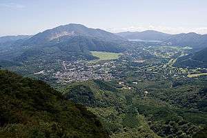
Sengokuhara viewed from Mount Kintoki
Sengokuhara (仙石原), sometimes called Sengokubara, is a district in Hakone, Kanagawa, Japan.
Geography
The district covers a total area of approximately 22 km²,[1] and is located in the northern part of the Hakone caldera. The area is designated a part of Fuji-Hakone-Izu National Park, and includes golf courses, cottages, hotels, and Japanese inns.
Mountains

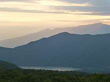
Mount Daigatake
- Mount Kintoki
- Mount Marudake
- Mount Kozuka
- Mount Daigatake
Passes
- Otome Pass
- Nagao Pass
- Kojiri Pass
Rivers
- Hayakawa River
Population
As of October 2010, the district has a population of 4,095, with 1,922 households.[1]
History
In 1626, a checkpoint was built in this district by the Tokugawa shogunate. In 1869, this checkpoint was abolished following the Meiji restoration. In 1889, the former village of Sengokuhara was founded. This was absorbed into the town of Hakone in 1956.
Sightseeing spots
- Hakone Botanical Garden of Wetlands (Shissei-Kaen Bus stop)
- The Little Prince and Saint-Exupéry Museum (Kawamukai Bus stop)
- Hakone Venetian Glass Museum (Venetian Grass Museum / Hyoseki Bus stop)
- Lalique Museum (Sengoku Annaijo Bus stop)
- Pola Museum of Art (Pola Museum Bus stop)
- Pampas grass viewing in autumn (Sengoku-Kogen Bus stop)
- Choan-ji Temple (Sengoku Bus stop)
Access by car
- from Odawara: National Route 1 and National Route 138
- from Gotemba: National Route 138
- from Lake Ashi: Kanagawa Prefectural Route 75
Major bus services
- Sengoku Bus Stop (仙石) 35°16′22″N 139°00′42″E / 35.272805°N 139.011637°E
- for Tōgendai (Lake Ashi)[2]
- for Hakone Yumoto Station and Odawara Station via Miyanoshita[3]
- for Yunnessun via Gora Station and Kowaki-en[4]
- for Shissei-Kaen[5]
- for Gotemba Premium Outlets and Gotemba Station[6]
- for Shinjuku Station (Tokyo) via Gotemba Station and Tomei-Gotemba
- for Hakone-en, Odakyu Hotel de Yama (next to Hakone Shrine) via Kojiri
- Sengoku Annaisho-mae Bus Stop (仙石案内所前) 35°16′17″N 139°00′36″E / 35.27130°N 139.01013°E
- for Tōgendai (Lake Ashi)[7]
- for Hakone Yumoto Station and Odawara Station via Miyanoshita[8]
- for Yunessun via Gōra Station and Kowaki-en[9]
- for Shissei-Kaen[10]
- for Gotemba Premium Outlets[11]
- for Shinjuku Station (Tokyo) via Gotemba Station and Tomei-Gotemba[12]
- for Hakone-en, Odakyu Hotel de Yama (next to Hakone Shrine) via Kojiri[12]
- for Haneda Airport via Yokohama Station[12]
- for Tokyo Station[12]
- Senkyoro-mae Bus Stop (仙郷楼前) 35°15′51″N 139°00′50″E / 35.26430°N 139.01392°E
- for Tōgendai (Lake Ashi)[13]
- for Hakone Yumoto Station and Odawara Station via Miyanoshita[14]
- for Yunnessun via Gora Station and Kowaki-en[15]
- for Shissei-Kaen and Gotemba Premium Outlets[16]
- for Shinjuku Station (Tokyo) via JR Gotemba Station and Tomei-Gotemba[12]
- for Hakone-en, Odakyu Hotel de Yama (next to Hakone Shrine) via Kojiri[12]
- for Haneda Airport via JR Yokohama Station[12]
- for Tokyo Station[12]
References
- 1 2 toukei-labo.com, analysis result of data of Statistics Bureau, Japan (Japanese)
- ↑ Sengoku Bus Stop timetable for Tōgendai
- ↑ Sengoku Bus Stop timetable for Hakone Yumoto & Odawara Station
- ↑ Sengoku Bus Stop timetable for Gora Station & Yunessun
- ↑ Sengoku Bus Stop timetable for Shissei-Kaen
- ↑ Sengoku Bus Stop timetable for Gotemba Premium Outlets
- ↑ Sengoku Annaisho-mae Bus Stop timetable for Tōgendai
- ↑ Sengoku Annaisho-mae Bus Stop timetable for Hakone Yumoto & Odawara Station
- ↑ Sengoku Annaisho-mae Bus Stop timetable for Gora Station & Yunessun
- ↑ Sengoku Annaisho-mae Bus Stop timetable for Shissei-Kaen
- ↑ Sengoku Annaisho-mae Bus Stop timetable for Gotemba Premium Outlets
- 1 2 3 4 5 6 7 8 Odakyu Hakone Highway Bus Timetable
- ↑ Senkyoromae Bus Stop timetable for Tōgendai
- ↑ Senkyoro-mae Bus Stop timetable for Hakone Yumoto & Odawara Station
- ↑ Senkyoro-mae Bus Stop timetable for Gora Station & Yunessun
- ↑ Senkyoro-mae Bus Stop timetable for Shissei-Kaen & Gotemba Premium Outlets
External links
- Official Hakone website (Japanese)
- Sengokuhara area guide (Hakone Ryokan Organization) (Japanese)
Coordinates: 35°16′11″N 139°00′37″E / 35.2696°N 139.0102°E
This article is issued from Wikipedia - version of the 6/5/2016. The text is available under the Creative Commons Attribution/Share Alike but additional terms may apply for the media files.