Sarangani Bay
| Sarangani Bay | |
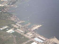
 An aerial view of the bay showing the port of General Santos | |
| Country | Philippines |
|---|---|
| Region | Southern Mindanao |
| Part of | Celebes Sea |
| Cities | Alabel, General Santos, Glan, Maasim, Malapatan |
| Coordinates | PH 05°58′N 125°11′E / 5.967°N 125.183°ECoordinates: PH 05°58′N 125°11′E / 5.967°N 125.183°E |
| Length | 33 km (21 mi), N-S |
| Width | 16 km (10 mi), E-W |
 North part of Sarangani Bay | |
Sarangani Bay is a bay located on the southern tip of Mindanao in the Philippines. It opens up to the Celebes Sea on the Pacific Ocean. General Santos City, one of the Philippines most important cities and ports, is located at the head of the bay, making the bay one of the busiest and often the sight of shipping accidents.[1] The province of Sarangani, created in 1992, is named after the bay.
References
- ↑ "2 vessels collide off Sarangani Bay; 2 missing". Philippine Star. 10 August 2011. Retrieved 13 August 2011.
This article is issued from Wikipedia - version of the 2/3/2016. The text is available under the Creative Commons Attribution/Share Alike but additional terms may apply for the media files.